Alay Mountains
The Alay or Alai Mountains (Kyrgyz: Алай тоо кыркасы; Russian: Алайский хребет) constitute a mountain range that extends from the Tien Shan mountain range in Kyrgyzstan west into Tajikistan. It is part of the Pamir-Alai mountain system. The range runs approximately east to west.[2] Its highest summit is Pik Tandykul (Russian: пик Тандыкуль), reaching 5544 m.[3] The southern slopes of the range drain into the Vakhsh River, a tributary of the Amu Darya. The streams that drain the northern slopes of the range are tributaries of the Syr Darya, and empty into the Fergana Valley to the north of the range. sv:Pik Skobeleva, 5051m, is also a well known summit. Roads from Erkeshtam to Osh pass through these mountains.
| Alay Mountains | |
|---|---|
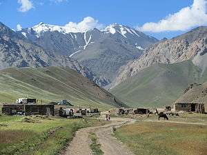 Alai Mountains from Jiptik Valley | |
| Highest point | |
| Elevation | 5,544 m (18,189 ft) |
| Dimensions | |
| Length | 350 km (220 mi) W-S [1] |
| Width | 20 km (12 mi) N-S [1] |
| Naming | |
| Native name | Kyrgyz: Алай тоо кыркасы |
| Geography | |
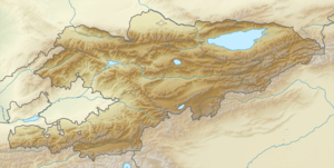 Location of the Alay Mountains | |
| Countries | Kyrgyzstan and Tajikistan |
| Regions | Batken Region and Osh Region |
| Range coordinates | 39°40′N 72°0′E |
Some inprecise sources seem to use the term for the whole southern curve of the Tian Shan corresponding to the southern border of Kyrgyzstan, to up north until the perpendicular extension known as Fergana Range, but Alay Mtns are strictly north of Alay Valley, while confusingly, Trans-Alay Range of Pamir Mountains lies to the south of that valley, as well as Turkestan Range and Zarafshan Range at far southwest. Pamir-Alay is collective term for many systems above, but not including any of the Pamirs.
References
- Атлас Кыргызской Республики [Atlas of Kyrgyz Republic] (in Russian). Bishkek: Academy of Sciences of Kyrgyz SSR. 1987. p. 156.
- M. Shahgedanova, The physical geography of northern Eurasia, Oxford University Press, 2003, ISBN 978-0-19-823384-8, chapter 16
- Soviet Union military map 1:500.000 J-42-Б
| Authority control |
|
|---|