Palus Putredinis
Palus Putredinis /ˈpeɪləs pjuːˈtrɛdɪnɪs/ (Latin palūs pūtrēdinis "Marsh of Decay")[1] is a small lunar mare in the basin of Mare Imbrium. It stretches from the crater Archimedes southeast toward the rugged Montes Apenninus range located on the southeastern edge of Mare Imbrium. This region is a nearly level, lava-flooded plain bounded by the crater Autolycus and nearby highlands to the northeast and the foothills of the Montes Archimedes to the southwest. The selenographic coordinates are 27.4° N, 0.0° E, and it lies within a diameter of 180 km.[1]
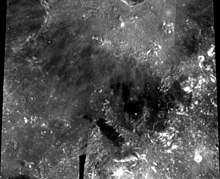
.png) Lunar Reconnaissance Orbiter image. Montes Apenninus are seen in the lower right, crater Archimedes in upper left and crater Autolycus on the top. | |
| Coordinates | 27.4°N 0.0°E |
|---|---|
| Diameter | 180 km |
| Eponym | Marsh of Decay |
In the southern part of this area is a rille system designated Rimae Archimedes. To the south is a prominent linear rille named Rima Bradley, and to the east is the Rima Hadley, which served as the landing site for Apollo 15, and the Rimae Fresnel. Just to the northwest of the Palus Putredinis midpoint is the nearly submerged crater Spurr. Luna 2 crashed in this area.
References
- "Palus Putredinis". Gazetteer of Planetary Nomenclature. USGS Astrogeology Research Program.
External links
| Wikimedia Commons has media related to Palus Putredinis. |