Palo Alto, Virginia
Palo Alto is an unincorporated community in Highland County, Virginia, United States.[1][2] Palo Alto is located 11.4 miles (18.3 km) east-northeast of Monterey, Virginia on the South Fork South Branch Potomac River. The confluence of Spring Run with the South Fork South Branch Potomac River occurs near the community and Highland County's border with Pendleton County, West Virginia is located less than 1⁄2 mile (0.80 km) north of Palo Alto.[3]
Palo Alto, Virginia | |
|---|---|
 Palo Alto  Palo Alto | |
| Coordinates: 38°25′24″N 79°22′13″W | |
| Country | United States |
| State | Virginia |
| County | Highland |
| Elevation | 2,139 ft (652 m) |
| Time zone | UTC−5 (Eastern (EST)) |
| • Summer (DST) | UTC−4 (EDT) |
| GNIS feature ID | 1497068[1] |
References
- "Palo Alto". Geographic Names Information System. United States Geological Survey. Retrieved December 22, 2013.
- Google (December 22, 2013). "Palo Alto, Virginia" (Map). Google Maps. Google. Retrieved December 22, 2013.
- "The National Map". United States Geological Survey. Retrieved February 7, 2014.
Municipalities and communities of Highland County, Virginia, United States | ||
|---|---|---|
| Town | 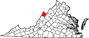 Map of Virginia highlighting Highland County | |
| Unincorporated communities | ||
| Footnotes | ‡This populated place also has portions in an adjacent county or counties | |
This article is issued from Wikipedia. The text is licensed under Creative Commons - Attribution - Sharealike. Additional terms may apply for the media files.