Pallabi Thana
Pallabi (Bengali: পল্লবি) is a thana of Dhaka District in the Division of Dhaka, Bangladesh. Pallabi Thana total area is 25.28 square kilometres (9.76 sq mi), located in between 23°48' and 23°52' north latitudes and in between 90°20' and 90°23' east longitudes. It is bounded by turag and uttara thanas on the north, mirpur model and shah ali thanas on the south, bimanbandar, cantonment and kafrul thanas on the east, savar upazila on the west.
Pallabi পল্লবী | |
|---|---|
Thana | |
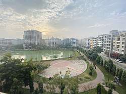
 Skyline of Pallabi, Bangladesh | |
 Pallabi Location in Bangladesh | |
| Coordinates: 23°49.5′N 90°22.2′E | |
| Country | |
| Division | Dhaka Division |
| District | Dhaka District |
| Area | |
| • Total | 17 km2 (7 sq mi) |
| Population (1991) | |
| • Total | 364,000 |
| • Density | 21,412/km2 (55,460/sq mi) |
| Time zone | UTC+6 (BST) |
| Website | bangladesh |
Geography
Pallabi is located at 23.495°N 90.215°E. Its total area is 17 km².
Demographics
Pallabi has a population of 364,000. Males constitute 52.74% of the population and females 47.26%. Pallabi has an average literacy rate of 56.23%, compared to the national average of 32.4%.
Administration
Pallabi has one union/ward, 16+27 mauzas/mahallas, and no villages.
See also
- Upazilas of Bangladesh
- Districts of Bangladesh
- Divisions of Bangladesh
References