Oronce Finé
Oronce Finé (or Fine;[1] Latin: Orontius Finnaeus or Finaeus; Italian: Oronzio Fineo; 20 December 1494 – 8 August 1555) was a French mathematician and cartographer.
Oronce Finé | |
|---|---|
 Oronce Finé | |
| Born | 20 December 1494 Briançon, France |
| Died | 8 August 1555 (age 60) Paris, France |
| Nationality | French |
| Scientific career | |
| Fields | Cartography, mathematics |
Life
Born in Briançon, the son and grandson of physicians, he was educated in Paris (Collège de Navarre) and obtained a degree in medicine in 1522.
He was imprisoned in 1524, probably for practicing judicial astrology.
In 1531, he was appointed to the chair of mathematics at the Collège Royal (the present Collège de France), founded by King Francis I, where he taught until his death.[2][3]
Mathematics

Although primarily a populariser, Finé was one of the most prolific authors of mathematical books of his age. He worked in a wide range of mathematical fields, including practical geometry, arithmetic, optics, gnomonics, astronomy and instrumentalism.[4]
He gave the value of pi (≈ 3.14159) to be 22 2⁄9/7 ≈ 3.1746 in 1544. Later, he gave 47/15 ≈ 3.1333 and, in De rebus mathematicis (1556), he gave 3+11/78 ≈ 3.1410.
Astronomy and geography
In 1542 Finé published De mundi sphaera (On the Heavenly Spheres), a popular astronomy textbook whose woodcut illustrations were much appreciated.[5] His writing on astronomy included guides to the use of astronomical equipment and methods (e.g. the ancient practice of determining longitude through the coordinated observation of lunar eclipses from two fixed points with enough distance between them to make the phenomena appear at different times of the night). He also described more recent innovations, such as an instrument he called a méthéoroscope (an astrolabe modified by adding a compass).
Explanatory work was complemented by direct contributions. His woodcut map of France (1525) is one of the first of its kind. He constructed an ivory sundial in 1524, which still exists.[6]
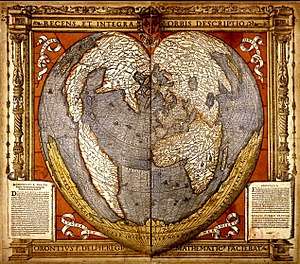
Finé's heart-shaped (cordiform) map projection may be his most famous illustration, and was frequently employed by other notable cartographers, including Peter Apian and Gerardus Mercator.[7]
Finé attempted to reconcile discoveries in the New World with old medieval legends and information (derived from Ptolemy) regarding the Orient. Thus, on one of his two world maps, Nova Universi Orbis Descriptio (1531), the legend marked Asia covers both North America and Asia, which were represented as one landmass. He used the toponym "America" for South America, and thus Marco Polo's Mangi, Tangut and Catay appear on the shores of the present-day Gulf of Mexico. On the same map, Finé drew Terra Australis to the south, including the legend "recently discovered but not yet completely explored", by which he meant the discovery of Tierra del Fuego by Ferdinand Magellan.[8]
Finé's cosmography was derived from the German mathematician and cosmographer Johannes Schöner.[9] In his study of Schöner's globes, Franz von Wieser, found that the derivation of Finé's mappemonde from them was "unmistakeable (unverkennbar)"; he said "Orontius Finaeus took from Schöner not only the 'Brasilie Regio'", but the whole Austral Continent, the Strait of Magellan, and above all the whole arrangement of lands; in a word, the mappemonde of Oronce Finé is a copy of Schöner's".[10] Lucien Gallois also noted the undeniable ressemblance parfaite between Finé's 1531 mappemonde and Schöner's globe of 1533.[11] As Schöner's globe of 1523, which also closely resembled Finé's mappemonde, was not identified until 1925 by Frederik (F.C.) Wieder, Gallois was forced to argue that Finé, who said he had been working on his mappemonde since 1521, had had direct or indirect personal communication with Schöner or had drawn upon his 1515 Luculentissima descriptio. Wieder's identification of Schöner's map gores of 1523 strengthens Gallois' case for Finé's reliance upon Schöner.[12]
Fine's 1536 world map bore a dedicatory inscription in the lower left corner, which stated:
ABOUT FIFTEEN years since, Dear Reader, we first designed, in the shape of a human heart, this universal map of the world, in gratitude to the Most Christian and Most Mighty Francis, King of the French, our most clement Maecenas. For while we saw the King, a Polymath, and uncommon Geographer, greatly pleased by all and praised by many, even in foreign countries, I wanted finally to communicate the same description of the whole globe to all students of Mathematics: which, after variations in fortune and crises in the studies we pursued, which up to now have been a hindrance to us, we have finally done at our own risk. And so, augmented and corrected by many observations of modern hydrographers, the same heart-shaped geographical image for yourself, devoted reader and for all men of goodwill, we present to a wise and liberal mind. It remains, therefore, that you will not refuse to accept this labour and industry of ours with a human appearance, and fairly and well consult it. Finally, while we strive ever more earnestly for the favour and generosity of our Most Christian and magnificent King, whose happiness and success you eagerly desire, we have shared this with you. Farewell, from Paris.[13]
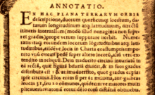
The same map bore another inscription in the lower right corner, which explained how to use the map to accurately measure the distances between places shown on it:
From the description of the world in this map, for any two locations of which the longitudes and latitudes are given (but not exceeding ninety degrees), close to the true direct distance between them can be calculated. Having thus reckoned the longitudes and latitudes of the places, their places in the chart being selected at the same time, place one foot of the compasses over the other places, and extend the other over the rest. Then the compasses trace an invariant straight line, which divides the figure equally, and the degrees are distributed between them; and you will observe how many degrees the compasses take in. If you multiply these by 62 miles, or 31 French leagues, or 20 common ones, by a tenth or more, that way, you will obtain the distances of any of these places.[14]
Death and legacy
Finé died in Paris at age 60.
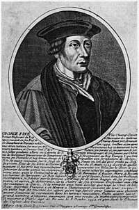
Jean Clouet is said to have painted a portrait of Finé in 1530, when Finé was 36. With the original painting lost, the rendering is now known only through prints derived from the original image.
Honours
The lunar crater Orontius and Finaeus Cove in Antarctica are named after Oronce Finé, using his Latinized name. In 2014, a square named after Oronce Fine was inaugurated in Paris, France.
See also
References
- For the debate over the French spelling of Finé's name see Alexander Marr, 'Introduction', in 'The Worlds of Oronce Fine: Mathematics, Instruments and Print in Renaissance France' (Shaun Tyas, 2009), pp. 1–12. Finé's name is often found spelt with an acute accent, but the Dictionnaire de Biographie française (ed. Roman D'Amat, Paris, 1975, p.1370) gives a very definite direction that his name should be spelt without an accent, "Fine, et non Finé".
- Isabelle Pantin, 'Oronce Fine's Role as Royal Lecturer', in Alexander Marr (ed.), 'The Worlds of Oronce Fine: Mathematics, Instruments and Print in Renaissance France' (Shaun Tyas, 2009), pp. 13–30.
- Alexander Marr, 'Introduction', in Alexander Marr (ed.), 'The Worlds of Oronce Fine: Mathematics, Instruments and Print in Renaissance France' (Shaun Tyas, 2009), pp. 1–12
- Adam Mosley, 'Early Modern Cosmography: Fine's Sphaera mundi in Content and Context', in Alexander Marr (ed.), 'The Worlds of Oronce Fine: Mathematics, Instruments and Print in Renaissance France' (Shaun Tyas, 2009), pp. 114–136.
- Catherine Eagleton, 'Oronce Fine's Sundials: The Sources and Influences of De solaribus horologiis', in Alexander Marr (ed.), 'The Worlds of Oronce Fine: Mathematics, Instruments and Print in Renaissance France' (Shaun Tyas, 2009), pp. 83–99
- Jean-Jacques Brioist, 'Oronce Fine and Cartographical Methods', in Alexander Marr (ed.), 'The Worlds of Oronce Fine: Mathematics, Instruments and Print in Renaissance France' (Shaun Tyas, 2009), pp. 137–155.
- Robert J. King, "Terra Australis Not Yet Known", National Library of Australia, Mapping our World: Terra Incognita to Australia, Canberra, National Library of Australia, 2013, p. 82. Image at Rare Maps from the State Library of New South Wales and at:
- Henry Harrisse, The Discovery of North America, London, 1892 (reprinted Amsterdam, N. Israel, 1961), p. 583.
- Franz von Wieser, Magalhães-Strasse und Austral-Continent. Auf den Globen Johannes Schöner. Beitrage zur Geschichte der Erdkunde im xvi. Jahrhundert, Innsbruck, 1881 (reprinted Amsterdam, Meridian, 1967), pp. 67, 79–80.
- Lucien Gallois, Les Géographes allemands de la Renaissance, Paris, Leroux, 1890 (repr. Amsterdam, Meridian, 1963), p. 92.
- F. C. Wieder (ed.), Monumenta Cartographica, The Hague, Martinus Nijhoff, 1925, Vol. I, pp. 1–4, "The Globe of Johannes Schöner, 1523–1524", and Plates 1–3.
- DECIMVSQVINTVS CIRCITER agitur annus, candide Lector, quo universam Orbis terrarum designationem, in hanc humani cordis effigiem primum redegimus: Idque in gratiam Christianissimi ac potentissimi FRANCISCI Francorum Regis, Mœcenatis nostri clementissimi. Quam dum videremus ipsi Regi, Polyhistori, ac non vulgari Geographo, valde placere ab omnibus quoque (etiam exteris) laudari plurimum: desiderabam eandem orbis descriptionem, universis Mathematicarum studiosis aliquando communicare. Quod post varia fortunae, ac studii nostri (quae hactenus nobis impedimento fuere) discrimina, tandem nostro effecimus periculo. Itaque plurimis recentiorum hydrographorum observationibus auctam, et emendatam ipsius geographici cordis imaginem, tibi studiose lector, cunctisque bonae voluntatis hominibus, cordato ac liberali praesentamus animo. Reliquum est igitur ut hunc laborem nostrum et industriam, humano vultu non graveris accipere, et aequi bonique consulas. Ipsi demum Christianissimo, ac magnifico Regi nostro, prosperam exoptes foelicitatem, cuius favore atque munificentia, haec (interea dum molimur graviora) tibi communicavimus. Vale, Luteciae Parisiorum.
- ANNOTATIO: Ex hac plana terrarum orbis descriptione, duorum quorumcumque locorum, datarum longitudinum atque latitudinum, directum itineris intervallum (modo illud nonaginta non superet gradus) prope verum supputate licebit. Numeratis itaque eorundem locorum longitundinibus atque latitudinibus, eiusdemque locis in Charta coassumptisum ponito unum circini pedem super altero locorum, asium vero extendito in reliquum. Dein traducito circinum invariatum in ea rectam, quae figura bifariam dividit, & in suos gradus distributa est: & animadvertito, quot gradus capiat ipse circinus. Hos enim si per 62 miliaria, aut gallicas leucas 31, seu 20 communes, qui decim ve maiores multiplicaveris: via totiam eorundem locorum distantia obtinebis.
Further reading
- Alexander Marr (ed.), 'The Worlds of Oronce Fine: Mathematics, Instruments and Print in Renaissance France' (Shaun Tyas, 2009)
External links
| Wikimedia Commons has media related to Oronce Finé. |
- Mathematicians: Fine
- Monique Pelletier, "The Cordiform World Maps by Oronce Fine," Cartographica Helvetica 12 (1995) 27–37: Summary.
- http://www.diegocuoghi.com/Piri_Reis/Finaeus.htm THE MYSTERIES OF THE PIRI REIS MAP: THE CART OF ORONTIUS FINAEUS (Oronce Fine)]
| Authority control |
|
|---|