Orangozinho
Orangozinho (Portuguese meaning Little Orango) is an island in the Bissagos Islands, Guinea-Bissau, it is part of the Bolama Region and the Bubaque sector. Its area is 107 km²,[2] its length is 19 km and its width is 11.8 km. It has a population of 706 (2009 census); the largest village is Wite.[1] The island forms a part of the Orango National Park.[3]
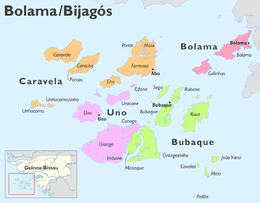 Orangozinho in the Uno Sector | |
| Geography | |
|---|---|
| Location | Atlantic Ocean |
| Coordinates | 11.11979°N 15.93155°W |
| Archipelago | Bijagós Archipelago |
| Area | 107 km2 (41 sq mi) |
| Length | 19 km (11.8 mi) |
| Width | 11.8 km (7.33 mi) |
| Administration | |
Guinea-Bissau | |
| Region | Bolama |
| Demographics | |
| Population | 706 (2009)[1] |
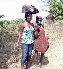
Getting supplies from Wite village
Neighbouring islands are Bubaque to the north, Roxa or Canhabaque to the northeast, Meneque to the west and Canogo to the northwest.
References
- População por região, sector e localidades por sexo censo 2009, Instituto Nacional de Estatística Guiné-Bissau
- Orangozinho in the Catalogue of Islands at UNEP (United Nations Environment Program) - accessed 16 November 2018
- Quadro nacional da biotecnologia e biosegurança da Guiné-Bissau, March 2008, p. 33
This article is issued from Wikipedia. The text is licensed under Creative Commons - Attribution - Sharealike. Additional terms may apply for the media files.