Opunake
Opunake (officially Ōpunake) is a small town on the southwest coast of Taranaki in New Zealand's North Island. It is located 45 kilometres southwest of New Plymouth. Rahotu is 16 km to the northwest. Manaia is 29 km to the southeast. State Highway 45 passes through the town.[2][3]
Opunake | |
|---|---|
 Opunake  Opunake | |
| Coordinates: 39°27′S 173°51′E | |
| Country | |
| Region | Taranaki |
| Territorial authority | South Taranaki District |
| Area | |
| • Urban | 3.73 km2 (1.44 sq mi) |
| Population (June 2019)[1] | |
| • Urban | 1,360 |
| • Urban density | 360/km2 (940/sq mi) |
| Postcode | 4616 |


The town has a population of 1,360 (June 2019).[1]
The town was settled in the 1880s.[4] It was intended to be a major port but, other than a jetty constructed in 1891, little else was completed.
Opunake is the centre for the local dairy industry, and is also a popular tourist spot. The beach is composed of volcanic blacksand and there are large rock pools to be found on the north-west end of the beach at low tide.
The Opunake and surrounding community has a South Taranaki District Council LibraryPlus, which provides full library and Council related services.
Opunake murals
From a rich farming history to Māori culture and modern industry, this set of wall murals found along the main road in the town of Opunake, Taranaki give just a little insight into what this region is about.
Assorted Wall Murals called "Reflections of Opunake" 1900 - 2000 Commissioned by the Egmont Arts Council. Designed and Painted by Mural Artist Dennis Lattimer during April/May 2002. Opunake, Taranaki, North Island, New Zealand.[5]


Marae
Opunake has two marae. Ōeo Marae and Tipua Horonuku and Tipua Hororangi meeting houses are affiliated with the Ngāruahine hapū of Ngāti Tamaahuroa me Tītahi. Ōrimupiko Marae and Ōhinetuhirau meeting house are a meeting place for the Taranaki hapū of Ngāti Haumia, Ngāti Tamarongo and Ngāti Kahumate.[6][7]
Education
Opunake High School is a coeducational secondary (years 9-13) school with a roll of 313 students as of March 2020.[8] The school celebrated its 75th jubilee in 2000.[9]
Opunake School, St Joseph's School, and Te Kura Kaupapa Maori o Tamarongo are full primary (years 1-8) schools with rolls of 205, 79 and 8 respectively.[8] St Joseph's is a state integrated Catholic school. Te Kura Kaupapa Maori o Tamarongo is a Kura Kaupapa Māori school which teaches in the Māori language.
Notable people
- Jim Bolger (born 1935), former New Zealand Prime Minister
- Carl Hayman (born 1979), rugby union footballer who played prop
- Graham Mourie (born 1952), All Black captain
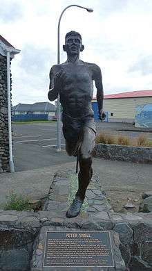
- Peter Snell (1938–2019), middle distance runner, a sculpture was unveiled on Saturday 19 May 2007
See also
- Opunake Branch
Notes
- "Subnational Population Estimates: At 30 June 2019". Statistics New Zealand. 22 October 2019. Retrieved 11 January 2020.
- Peter Dowling (editor) (2004), Reed New Zealand Atlas, Reed Books, map 34, ISBN 0-7900-0952-8CS1 maint: extra text: authors list (link)
- Roger Smith, GeographX (2005), The Geographic Atlas of New Zealand, Robbie Burton, map 96, ISBN 1-877333-20-4
- "Opunake Travel Guide". Jasons Travel Media.
- http://www.new-zealand-pictures.co.nz/
- "Te Kāhui Māngai directory". tkm.govt.nz. Te Puni Kōkiri.
- "Māori Maps". maorimaps.com. Te Potiki National Trust.
- "New Zealand Schools Directory". New Zealand Ministry of Education. Retrieved 26 April 2020.
- "Jubilees & reunions - Opunake High School", Education Gazette New Zealand, 78 (16), 13 September 1999