Opole Lubelskie County
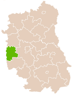
Opole Lubelskie County (Polish: powiat opolski) is a unit of territorial administration and local government (powiat) in Lublin Voivodeship, eastern Poland. It was established on January 1, 1999, as a result of the Polish local government reforms passed in 1998. Its administrative seat is the town of Opole Lubelskie, which lies 44 kilometres (27 mi) west of the regional capital Lublin. The only other town in the county is Poniatowa, lying 8 km (5 mi) north-east of Opole Lubelskie.
Opole Lubelskie County Powiat opolski | |
|---|---|
 Flag  Coat of arms | |
 | |
| Coordinates (Opole Lubelskie): 51°9′N 21°58′E | |
| Country | |
| Voivodeship | Lublin |
| Seat | Opole Lubelskie |
| Gminas | |
| Area | |
| • Total | 804.14 km2 (310.48 sq mi) |
| Population (2006) | |
| • Total | 63,026 |
| • Density | 78/km2 (200/sq mi) |
| • Urban | 18,743 |
| • Rural | 44,283 |
| Car plates | LOP |
| Website | http://www.opole.lublin.pl |
The county covers an area of 804.14 square kilometres (310.5 sq mi). As of 2006, its total population is 63,026, including 9,911 in Poniatowa, 8,832 in Opole Lubelskie, and a rural population of 44,283.
Neighbouring counties
Opole Lubelskie County is bordered by Puławy County to the north, Lublin County to the east, Kraśnik County to the south-east, Opatów County to the south-west, Lipsko County to the west and Zwoleń County to the north-west.
Administrative division
The county is subdivided into seven gminas (three urban-rural and four rural). These are listed in the following table, in descending order of population.
| Gmina | Type | Area (km²) |
Population (2006) |
Seat |
| Gmina Opole Lubelskie | urban-rural | 193.8 | 17,795 | Opole Lubelskie |
| Gmina Poniatowa | urban-rural | 84.2 | 15,146 | Poniatowa |
| Gmina Józefów nad Wisłą | urban-rural | 141.6 | 6,997 | Józefów nad Wisłą |
| Gmina Chodel | rural | 108.2 | 6,771 | Chodel |
| Gmina Karczmiska | rural | 95.2 | 6,192 | Karczmiska |
| Gmina Łaziska | rural | 109.3 | 5,262 | Łaziska |
| Gmina Wilków | rural | 79.5 | 4,863 | Wilków |
References
Seat: Opole Lubelskie | ||
| Urban-rural gminas | | |
| Rural gminas | ||
| City counties |
|  |
|---|---|---|
| Land counties | ||