Old Shawneetown, Illinois
Old Shawneetown is a village in Gallatin County, Illinois, United States. As of the 2010 census, the village had a population of 193,[3] down from 278 at the 2000 census. Located along the Ohio River, Shawneetown served as an important United States government administrative center for the Northwest Territory. The village was devastated by the Ohio River flood of 1937. The village's population was moved several miles inland to New Shawneetown.

Old Shawneetown, Illinois | |
|---|---|
Village | |
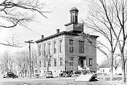 Old Shawneetown Court House in 1937 | |
 Location of Old Shawneetown in Gallatin County, Illinois. | |
.svg.png) Location of Illinois in the United States | |
| Coordinates: 37°41′54″N 88°8′13″W | |
| Country | United States |
| State | Illinois |
| County | Gallatin |
| Area | |
| • Total | 0.53 sq mi (1.38 km2) |
| • Land | 0.53 sq mi (1.38 km2) |
| • Water | 0.00 sq mi (0.00 km2) |
| Population (2010) | |
| • Total | 193 |
| • Estimate (2016)[2] | 176 |
| • Density | 329.59/sq mi (127.23/km2) |
| Time zone | UTC-6 (CST) |
| • Summer (DST) | UTC-5 (CDT) |
| ZIP Code(s) | 62984 |
| Area code(s) | 618 |
| FIPS code | 17-55756 |
| Wikimedia Commons | Old Shawneetown, Illinois |
History
At least one record suggests that a village was established here by the Pekowi Shawnee led by Peter Chartier about 1748.[4] In early November 1803, Lewis and Clark are believed to have stopped at Old Shawneetown on their way to Fort Massac, just down the Ohio River.[5]
After the American Revolution, Shawneetown served as an important United States government administrative center for the Northwest Territory. Shawneetown and Washington, D.C., share the distinction of being the only towns chartered by the United States government.
Old Shawneetown is the site of the first bank chartered in Illinois, in 1816.[6] Originally in a log cabin, it was replaced in 1822 with a brick structure (only the second one in the town) now known as the John Marshall House.[7]
Local legend states that the Shawneetown Bank refused to buy the first bonds issued by the city of Chicago on the grounds that no city located that far from a navigable river could survive.
Another historic bank building, the Bank of Illinois, was constructed in 1839-41 to house the offices of the Bank of Illinois at Shawneetown. It later housed numerous other financial institutions before it was closed in the 1930s. This fine example of Greek Revival architecture survives as the Shawneetown Bank State Historic Site.
Residents long remembered the visit by Gilbert du Motier, Marquis de Lafayette of France to the city on May 8, 1825, as a high point for the early community's social history.[8]
Notable people
- Claudia Cassidy, music and drama critic for the Chicago Tribune
- Peter Chartier, Shawnee Indian chief
- Robert G. Ingersoll, orator
- Michael Kelly Lawler, Union Army officer
- John McLean, U.S. senator and congressman
- John Alexander McClernand, Union Army general and U.S. congressman
- William W. Wilshire, U.S. congressman
- Bluford Wilson, Union Army officer
- James Harrison Wilson, Union Army general
Geography
Old Shawneetown is located in southeastern Gallatin County at 37°41′54″N 88°8′13″W (37.698197, -88.136857),[9] on the northwest bank of the Ohio River. Illinois Route 13 passes through the village. To the east it crosses the Shawneetown Bridge over the Ohio, becoming Kentucky Route 56 and leading 13 miles (21 km) to Morganfield, Kentucky. To the west, IL 13 leads 3 miles (5 km) to Shawneetown, the Gallatin County seat, and 23 miles (37 km) to Harrisburg.
According to the 2010 census, Old Shawneetown has a total area of 0.53 square miles (1.37 km2), all land.[3]
In 2019, Old Shawneetown was featured on PBS News Hour in a segment on communities subjected to repeated flooding.[10] Because of the town's historically flood-prone location, it is prohibitively difficult to insure, and some researchers have recommended a total relocation of the remaining residents as a preventative policy.
Demographics
| Historical population | |||
|---|---|---|---|
| Census | Pop. | %± | |
| 1830 | 446 | — | |
| 1840 | 1,900 | 326.0% | |
| 1850 | 1,764 | −7.2% | |
| 1860 | 1,115 | −36.8% | |
| 1870 | 1,309 | 17.4% | |
| 1880 | 1,851 | 41.4% | |
| 1890 | 1,570 | −15.2% | |
| 1900 | 1,698 | 8.2% | |
| 1910 | 1,863 | 9.7% | |
| 1920 | 1,368 | −26.6% | |
| 1930 | 1,440 | 5.3% | |
| 1940 | 1,357 | −5.8% | |
| 1950 | 578 | −57.4% | |
| 1960 | 433 | −25.1% | |
| 1970 | 342 | −21.0% | |
| 1980 | 396 | 15.8% | |
| 1990 | 356 | −10.1% | |
| 2000 | 278 | −21.9% | |
| 2010 | 193 | −30.6% | |
| Est. 2016 | 176 | [2] | −8.8% |
| U.S. Decennial Census[11] | |||
As of the census[12] of 2000, there were 278 people, 100 households, and 69 families residing in the village. The population density was 531.7 people per square mile (206.4/km²). There were 146 housing units at an average density of 279.2/sq mi (108.4/km²). The racial makeup of the village was 99.64% White and 0.36% Native American. Hispanic or Latino of any race were 1.08% of the population.
There were 100 households out of which 36.0% had children under the age of 18 living with them, 44.0% were married couples living together, 20.0% had a female householder with no husband present, and 31.0% were non-families. 24.0% of all households were made up of individuals and 7.0% had someone living alone who was 65 years of age or older. The average household size was 2.78 and the average family size was 3.36.
In the village, the population was spread out with 33.8% under the age of 18, 8.3% from 18 to 24, 27.0% from 25 to 44, 22.7% from 45 to 64, and 8.3% who were 65 years of age or older. The median age was 32 years. For every 100 females, there were 98.6 males. For every 100 females age 18 and over, there were 93.7 males.
The median income for a household in the village was $18,214, and the median income for a family was $20,625. Males had a median income of $25,625 versus $13,750 for females. The per capita income for the village was $9,379. About 33.3% of families and 39.4% of the population were below the poverty line, including 60.6% of those under the age of eighteen and 33.3% of those sixty five or over.
See also
- List of cities and towns along the Ohio River
Further reading
- 1887. History of Gallatin, Saline, Hamilton, Franklin and Williamson Counties, Illinois. Chicago: Goodspeed Publishing Co.
- Musgrave, Jon, ed. 2002. Handbook of Old Gallatin County and Southeastern Illinois. Marion, Ill.: IllinoisHistory.com. 464 pages.
- Musgrave, Jon. 2004, Rev. ed. 2005. Slaves, Salt, Sex & Mr. Crenshaw: The Real Story of the Old Slave House and America's Reverse Underground R.R.. Marion, Ill.: IllinoisHistory.com. 608 pages.
- Waggoner, Horace Q., interviewer. 1978. "Lucille Lawler Memoir" Shawneetown Bank Project. Sangamon State University. Springfield, Ill.
Notes
- "2016 U.S. Gazetteer Files". United States Census Bureau. Retrieved Jun 30, 2017.
- "Population and Housing Unit Estimates". Retrieved June 9, 2017.
- "G001 - Geographic Identifiers - 2010 Census Summary File 1". United States Census Bureau. Archived from the original on 2020-02-13. Retrieved 2015-12-25.
- "Hanna on Peter Charter", E.P. Grondine, posted Thu Feb 14, 2013.
- The Journals of Lewis and Clark, Nov. 11, 1803.
- "Tidbits". Ludington Daily News. Aug 4, 2001. p. 33. Retrieved 15 October 2015.
- Christiana Holmes Tillson; Milo Milton Quaife, ed. 1919, Reprint 1995. A Woman's Story of Pioneer Illinois. Carbondale, Ill.: Southern Illinois University Press. 49-65.
- 1887. History of Gallatin, Saline, Hamilton, Franklin and Williamson Counties, Illinois. Chicago: Goodspeed Publishing Company. 96-97.
- "US Gazetteer files: 2010, 2000, and 1990". United States Census Bureau. 2011-02-12. Retrieved 2011-04-23.
- Cat Wise (2019-05-28). "The radical approach these communities have taken to flooding". PBS NewsHour. Retrieved 2019-05-29.
- "Census of Population and Housing". Census.gov. Retrieved June 4, 2015.
- "U.S. Census website". United States Census Bureau. Retrieved 2008-01-31.
Municipalities and communities of Gallatin County, Illinois, United States | ||
|---|---|---|
| City | Map of Illinois highlighting Gallatin County | |
| Villages | ||
| Townships | ||
| Unincorporated communities | ||