Okinawa Urban Monorail
The Okinawa Urban Monorail (沖縄都市モノレール, Okinawa Toshi Monorēru), also known as Yui Rail (ゆいレール, Yui Rēru), is a monorail line serving the cities of Naha and Urasoe, Okinawa, Japan. Operated by Okinawa Urban Monorail, Inc. (沖縄都市モノレール株式会社, Okinawa Toshi Monorēru Kabushiki-gaisha), it opened on August 10, 2003, and is the only public rail system in Okinawa Prefecture. Yui Rail is the first rail line on Okinawa since World War II. As Okinawa is the island of Japan lying farthest to the south and west that has an active rail line, Akamine Station and Naha Airport Station, the southernmost and westernmost rail stations in Japan respectively, lie on this line. It uses the OKICA as its contactless smart card, and integrates with Suica and other major Japanese IC cards (such as ICOCA or SUGOCA) from 10 March 2020.[3][4]
| Industry | Rail transport |
|---|---|
| Founded | August 10, 2003 |
| Headquarters | |
Area served | Naha and Urasoe Okinawa Prefecture, Japan |
| Services | Monorail |
| Owner | Okinawa Urban Monorail, Inc. |
| Website | www |
 1000 series train on the Okinawa Urban Monorail | |||
| Overview | |||
|---|---|---|---|
| Locale | Naha and Urasoe Okinawa Prefecture, Japan | ||
| Transit type | straddle-beam monorail | ||
| Number of lines | 1 | ||
| Number of stations | 19 | ||
| Daily ridership | 49,716 per day (2017) | ||
| Operation | |||
| Began operation | August 2003 | ||
| Operator(s) | Okinawa Urban Monorail, Inc. | ||
| Technical | |||
| System length | 17 km (11 mi)[1] | ||
| |||
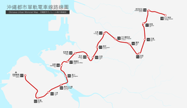
Yui Rail - Stations | |||||||||||||||||||||||||||||||||||||||||||||||||||||||||||||||||||||||||||||||||||||||||||||||||||||||||||||||||||||||||||||||||||||||||||||||||||
|---|---|---|---|---|---|---|---|---|---|---|---|---|---|---|---|---|---|---|---|---|---|---|---|---|---|---|---|---|---|---|---|---|---|---|---|---|---|---|---|---|---|---|---|---|---|---|---|---|---|---|---|---|---|---|---|---|---|---|---|---|---|---|---|---|---|---|---|---|---|---|---|---|---|---|---|---|---|---|---|---|---|---|---|---|---|---|---|---|---|---|---|---|---|---|---|---|---|---|---|---|---|---|---|---|---|---|---|---|---|---|---|---|---|---|---|---|---|---|---|---|---|---|---|---|---|---|---|---|---|---|---|---|---|---|---|---|---|---|---|---|---|---|---|---|---|---|---|
| |||||||||||||||||||||||||||||||||||||||||||||||||||||||||||||||||||||||||||||||||||||||||||||||||||||||||||||||||||||||||||||||||||||||||||||||||||
Yui Rail
The monorail's "Yui Rail" brand name and logo were selected in a public competition.[5] It consists of 19 stations, from Naha Airport in the west to Tedako-Uranishi in the east, running via Naha.[6] The average distance between stations is 0.93 kilometers. It takes 37 minutes and costs ¥370[6] to traverse its 17 km length.[1]
Trains are made up of two cars, with 65 seats and a total capacity of 165 people.[1] Trains runs on an elevated track between 8 and 20 meters above the ground, with a top speed of 65 km/h (about 40 mph) and an actual average speed of 28 km/h (17 mph) counting stops.[1]
Urasoe Extension
After lengthy deliberation of possible route options, the monorail corporation applied for construction permission for a 4.1-kilometer, 4-station extension from Shuri Station to Tedako-Uranishi Station (Urasoe City) in August 2011.[7] Permission was granted on January 26, 2012, with construction planned to start in March 2013. Revenue operation along the extension started on October 1, 2019, using a revised schedule with extended rush hour headways for opening day.[8][9][10]
Preliminary ridership data from the first week showed that year-on-year ridership was up after the extension opened on Oct. 1.[11]
Stations
| Station No. |
Station name | Distance in km |
Total distance |
Location | ||
|---|---|---|---|---|---|---|
| English | Japanese | |||||
| 1 | Naha Airport | 那覇空港 | - | 0.00 | Naha | |
| 2 | Akamine | 赤嶺 | 1.95 | 1.95 | ||
| 3 | Oroku | 小禄 | 0.76 | 2.71 | ||
| 4 | Onoyama Park | 奥武山公園 | 0.97 | 3.68 | ||
| 5 | Tsubogawa | 壺川 | 0.84 | 4.52 | ||
| 6 | Asahibashi | 旭橋 | 0.81 | 5.33 | ||
| 7 | Prefectural Office | 県庁前 | 0.58 | 5.91 | ||
| 8 | Miebashi | 美栄橋 | 0.72 | 6.63 | ||
| 9 | Makishi | 牧志 | 0.98 | 7.61 | ||
| 10 | Asato | 安里 | 0.59 | 8.2 | ||
| 11 | Omoromachi | おもろまち | 0.75 | 8.95 | ||
| 12 | Furujima | 古島 | 1.01 | 9.96 | ||
| 13 | Naha City Hospital | 市立病院前 | 0.92 | 10.88 | ||
| 14 | Gibo | 儀保 | 0.96 | 11.84 | ||
| 15 | Shuri | 首里 | 1.00 | 12.84 | ||
| 16 | Ishimine | 石嶺 | 1.06 | 13.90 | ||
| 17 | Kyozuka | 経塚 | 1.20 | 15.00 | Urasoe | |
| 18 | Urasoe-Maeda | 浦添前田 | 1.00 | 16.00 | ||
| 19 | Tedako-Uranishi | てだこ浦西 | 1.00 | 17.00 | ||
See also
- Monorails in Japan
- List of rapid transit systems
- Rail transportation in Okinawa
References
- モノレール計画概要 Archived 2015-04-09 at the Wayback Machine, yui-rail.co.jp (Japanese)
- "about Barrier-free", yui-rail.co.jp (Japanese)
- okinawatimes. 24 May 2019.
- "令和2年3月10日より「Suica」およびSuicaと相互利用する交通系ICカードの利用が始まりました".
- "about Yui Rail" Archived 2008-04-23 at the Wayback Machine, yui-rail.co.jp (Japanese)
- ご利用案內 Archived 2014-02-20 at the Wayback Machine, yui-rail.co.jp (Japanese)
- http://www.okinawatimes.co.jp/article/2011-08-30_22758/ Archived September 28, 2011, at the Wayback Machine
- http://sankei.jp.msn.com/economy/news/120126/biz12012617240026-n1.htm Archived January 27, 2012, at the Wayback Machine
- https://ryukyushimpo.jp/news/entry-989510.html
- "Now operational: Monorail extension into Urasoe adds four new stations". Ryukyu Shimpo - Okinawa, Japanese newspaper, local news.
- "沖縄のモノレール延長から1週間 利用者は1日どのくらい増えたか?". Okinawa Times.
External links
| Wikimedia Commons has media related to Okinawa Monorail. |
- Official website (in Japanese)
- Official website (in English)
- Yui Rail Museum (in English)