Bischofsheim in der Rhön
Bischofsheim in der Rhön (before January 2020: Bischofsheim an der Rhön) is a town in the district Rhön-Grabfeld, in Bavaria, Germany. It is situated in the Rhön Mountains, 29 km southeast of Fulda.
Bischofsheim i.d.Rhön | |
|---|---|
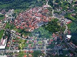 Aerial view | |
.svg.png) Coat of arms | |
Location of Bischofsheim i.d.Rhön within Rhön-Grabfeld district 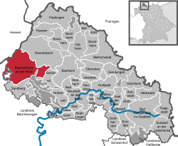 | |
 Bischofsheim i.d.Rhön  Bischofsheim i.d.Rhön | |
| Coordinates: 50°24′N 10°01′E | |
| Country | Germany |
| State | Bavaria |
| Admin. region | Unterfranken |
| District | Rhön-Grabfeld |
| Subdivisions | 5 Stadtteile |
| Government | |
| • Mayor | Georg Seiffert (CSU) |
| Area | |
| • Total | 67.72 km2 (26.15 sq mi) |
| Elevation | 448 m (1,470 ft) |
| Population (2018-12-31)[1] | |
| • Total | 4,825 |
| • Density | 71/km2 (180/sq mi) |
| Time zone | CET/CEST (UTC+1/+2) |
| Postal codes | 97653 |
| Dialling codes | 09772 |
| Vehicle registration | NES |
| Website | www.bischofsheim-rhoen.de |
Town Structure
Several originally separate villages became part of the town Bischofsheim. These are Frankenheim, Haselbach, Oberweißenbrunn, Unterweißenbrunn and Wegfurt.
History
In a document of the early 13th century Bischofsheim was first mentioned. The town is much older, probably 8th century. The name Bischofsheim (German: home of the bishop) indicates that the town was maybe founded by Saint Boniface. As Bischofsheim is situated between Fulda and the palatinate Salz, Boniface founded a settlement to rest on the way.
Sights
- Kreuzberg, 2nd highest mountain of the Rhön Mountains (932 metres)
- Kloster Kreuzberg (monastery, built 1681 – 1692)
- Town tower Zehntturm (13th century, 26 metres high)
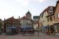 Market place of Bischofsheim
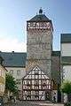 Tower „Zentturm“
_9596.jpg) Crosses on the Kreuzberg
Crosses on the Kreuzberg
Born in Bischofsheim
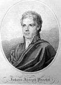
Johann Joseph von Prechtl around 1815
- Johann Joseph von Prechtl (1778-1854), Austrian technical researcher
- Hans Schlenck (1901-1944), German stage and film actor, theater director
- Hermann Hartmann (1914-1984), German chemist
References
- "Fortschreibung des Bevölkerungsstandes". Bayerisches Landesamt für Statistik und Datenverarbeitung (in German). July 2019.
External links
| Authority control |
|
|---|
This article is issued from Wikipedia. The text is licensed under Creative Commons - Attribution - Sharealike. Additional terms may apply for the media files.