Oberweißbach
Oberweißbach (or Oberweissbach, German: [oː.bɐ.ˈvaɪ̯s.bax] (![]()

Oberweißbach | |
|---|---|
Ortsteil of Schwarzatal | |
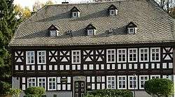 Friedrich Fröbel's birthplace in Oberweißbach | |
 Coat of arms | |
Location of Oberweißbach within Schwarzatal  | |
 Oberweißbach  Oberweißbach | |
| Coordinates: 50°34′58″N 11°8′40″E | |
| Country | Germany |
| State | Thuringia |
| District | Saalfeld-Rudolstadt |
| Municipal assoc. | Bergbahnregion/Schwarzatal |
| Town | Schwarzatal |
| Area | |
| • Total | 9.62 km2 (3.71 sq mi) |
| Elevation | 670 m (2,200 ft) |
| Population (2017-12-31) | |
| • Total | 1,678 |
| • Density | 170/km2 (450/sq mi) |
| Time zone | CET/CEST (UTC+1/+2) |
| Postal codes | 98744 |
| Dialling codes | 036705 |
| Vehicle registration | SLF |
| Website | Official website |
Overview
Oberweißbach is situated in the Thuringian Forest, 17 km (11 mi) southwest of Saalfeld. On 1 December 2008, it incorporated the former municipality Lichtenhain/Bergbahn.
Geography
Oberweißbach is a nationally recognized resort town in the Thuringian Forest Nature Park in the Weißbachtal.
It was the seat of the former municipal administration Bergbahnregion/Schwarzatal with communities of Cursdorf, Deesbach, Katzhütte, Oberweißbach and Meuselbach-Schwarzmühle. Colloquially this area is called Raanz, based on the primary transportation method of the pharmacists, the backpack. These pharmacists shaped this region between the 16th and 20th centuries.
The town of Oberweißbach consists of two districts:
- Oberweißbach / Thüringer Wald and
- Lichtenhain/Bergbahn.
References
External links
![]()
| Authority control |
|
|---|