Nyong River
The Nyong (formerly German: Yong) is a river in Cameroon. The river flows approximately 690 kilometres (430 mi) to empty into the Gulf of Guinea.
| Nyong river Yong | |
|---|---|
 Nyong River | |
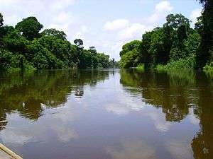
 The Nyong River in Cameroon | |
| Location | |
| Country | Cameroon |
| Regions | Littoral Region, East Region, South Region, Centre RegionCentre Region |
| Cities | Abong-Mbang, Mbalmayo |
| Physical characteristics | |
| Source | |
| ⁃ location | Near Abong-Mbang |
| ⁃ coordinates | 3°52′00″N 13°28′00″E |
| ⁃ elevation | 690 m (2,260 ft) |
| Mouth | Bight of Biafra |
⁃ coordinates | 3°15′39″N 9°54′16″E |
⁃ elevation | 0 m |
| Length | 690 km (430 mi) |
| Basin size | 27,800 km2 (10,734 sq mi) [1] |
| Discharge | |
| ⁃ location | Déhané |
| ⁃ average | 446 m3/s (15,800 cu ft/s) |
| ⁃ minimum | 40 m3/s (1,400 cu ft/s) |
| ⁃ maximum | 1,226 m3/s (43,300 cu ft/s) |
| Basin features | |
| River system | Nyong River |
| Population | 1,179,200 |
| Tributaries | |
| ⁃ left | Long Mafok, Soo, Soumou, Kama [1] |
| ⁃ right | Kom, Mfoumou, Afamba, Ato, Mefou, Akono, Liyeke, Kéllé [1] |
| Waterfalls | Trappenbeck Rapids |
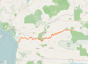
Course
The Nyong originates 40 km (25 mi) east of the town of Abong-Mbang, where the northern rain forest feeds it.[2] The river's length is almost parallel to the lower reaches of the Sanaga River. Its mouth is in Petit Batanga, 60 km (40 mi) south-southwest of Edéa.[3] In two places, Mbalmayo and Déhané, the river has huge rapids. The first 400 km (250 mi) of the river, between Abong-Mbang and Mbalmayo, are navigable for small boats from April to November.

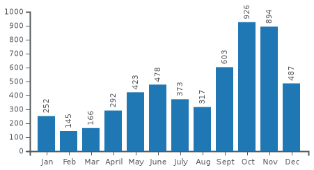
Slope of Nyong River
Transport
The town of Mbalmayo, which has a railhead, lies on the north bank of this river.[2] The towns of Akonolinga and Abong-Mbang also lie on it.
References
- PDF about the Hydrology of Cameroon (french)
- Runge, Jürgen (2012-05-30). Landscape Evolution, Neotectonics and Quaternary Environmental Change in Southern Cameroon: Palaeoecology of Africa Vol. 31, An International Yearbook of Landscape Evolution and Palaeoenvironments. CRC Press. p. 157. ISBN 9780415677356.
- Office, United States Hydrographic (1952). Publications ... U.S. Government Printing Office. p. 123.
This article is issued from Wikipedia. The text is licensed under Creative Commons - Attribution - Sharealike. Additional terms may apply for the media files.