Nortonville, Kansas
Nortonville is a city in Jefferson County, Kansas, United States. As of the 2010 census, the city population was 637.[6] It is part of the Topeka, Kansas Metropolitan Statistical Area.
Nortonville, Kansas | |
|---|---|
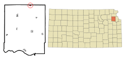 Location within Jefferson County and Kansas | |
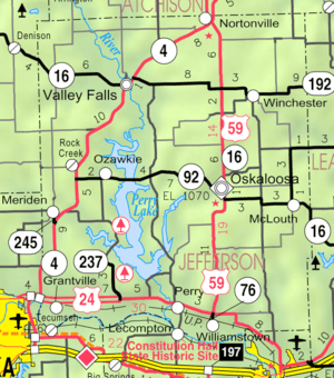 KDOT map of Jefferson County (legend) | |
| Coordinates: 39°25′3″N 95°19′54″W | |
| Country | United States |
| State | Kansas |
| County | Jefferson |
| Platted | 1873 |
| Incorporated | 1884 |
| Named for | L. Norton, Jr |
| Area | |
| • Total | 0.45 sq mi (1.17 km2) |
| • Land | 0.44 sq mi (1.14 km2) |
| • Water | 0.01 sq mi (0.03 km2) |
| Elevation | 1,165 ft (355 m) |
| Population | |
| • Total | 637 |
| • Estimate (2018)[3] | 609 |
| • Density | 1,400/sq mi (540/km2) |
| Time zone | UTC-6 (CST) |
| • Summer (DST) | UTC-5 (CDT) |
| ZIP code | 66060 |
| Area code | 913 |
| FIPS code | 20-51525 [4] |
| GNIS ID | 0478236 [5] |
| Website | nortonvilleks.com |
History
Nortonville was platted in 1873.[7] It was named for L. Norton, Jr., a railroad employee.[8] The first post office in Nortonville was established in May 1873.[9]
In the 1900s, Nortonville was reported to be one of three sundown towns in the state, where African Americans were not allowed to reside.[10][11]
Geography
Nortonville is located at 39°25′3″N 95°19′54″W (39.417496, -95.331626).[12] According to the United States Census Bureau, the city has a total area of 0.45 square miles (1.17 km2), of which, 0.44 square miles (1.14 km2) is land and 0.01 square miles (0.03 km2) is water.[1]
Demographics
| Historical population | |||
|---|---|---|---|
| Census | Pop. | %± | |
| 1880 | 350 | — | |
| 1890 | 669 | 91.1% | |
| 1900 | 700 | 4.6% | |
| 1910 | 638 | −8.9% | |
| 1920 | 696 | 9.1% | |
| 1930 | 606 | −12.9% | |
| 1940 | 562 | −7.3% | |
| 1950 | 568 | 1.1% | |
| 1960 | 595 | 4.8% | |
| 1970 | 727 | 22.2% | |
| 1980 | 692 | −4.8% | |
| 1990 | 643 | −7.1% | |
| 2000 | 620 | −3.6% | |
| 2010 | 637 | 2.7% | |
| Est. 2018 | 609 | [3] | −4.4% |
| U.S. Decennial Census | |||
2010 census
As of the census[2] of 2010, there were 637 people, 232 households, and 175 families residing in the city. The population density was 1,447.7 inhabitants per square mile (559.0/km2). There were 261 housing units at an average density of 593.2 per square mile (229.0/km2). The racial makeup of the city was 97.8% White, 0.5% Native American, 0.2% from other races, and 1.6% from two or more races. Hispanic or Latino of any race were 2.2% of the population.
There were 232 households of which 37.1% had children under the age of 18 living with them, 63.4% were married couples living together, 7.3% had a female householder with no husband present, 4.7% had a male householder with no wife present, and 24.6% were non-families. 22.0% of all households were made up of individuals and 13.3% had someone living alone who was 65 years of age or older. The average household size was 2.61 and the average family size was 3.05.
The median age in the city was 40.2 years. 27.2% of residents were under the age of 18; 5.7% were between the ages of 18 and 24; 23.1% were from 25 to 44; 22.5% were from 45 to 64; and 21.4% were 65 years of age or older. The gender makeup of the city was 49.0% male and 51.0% female.
2000 census
As of the census[4] of 2000, there were 620 people, 233 households, and 154 families residing in the city. The population density was 1,443.6 people per square mile (556.7/km²). There were 255 housing units at an average density of 593.8 per square mile (229.0/km²). The racial makeup of the city was 97.10% White, 0.32% African American, 0.65% Native American, 0.48% from other races, and 1.45% from two or more races. Hispanic or Latino of any race were 1.29% of the population.
There were 233 households out of which 32.6% had children under the age of 18 living with them, 57.9% were married couples living together, 7.3% had a female householder with no husband present, and 33.5% were non-families. 30.0% of all households were made up of individuals and 21.5% had someone living alone who was 65 years of age or older. The average household size was 2.46 and the average family size was 3.10.
In the city, the population was spread out with 26.0% under the age of 18, 6.9% from 18 to 24, 24.4% from 25 to 44, 16.5% from 45 to 64, and 26.3% who were 65 years of age or older. The median age was 40 years. For every 100 females, there were 87.9 males. For every 100 females age 18 and over, there were 80.7 males.
The median income for a household in the city was $38,281, and the median income for a family was $40,781. Males had a median income of $32,250 versus $18,500 for females. The per capita income for the city was $15,523. About 6.1% of families and 9.1% of the population were below the poverty line, including 13.4% of those under age 18 and 6.5% of those age 65 or over.
Education
Nortonville is served by USD 339 Jefferson County North. School unification consolidated Nortonville and Winchester schools forming USD 339. The Jefferson County North High School mascot is Jefferson County Chargers. Jefferson County North Elementary and Middle School is located in Nortonville.[13]
Nortonville High School was closed through school unification. The Nortonville High School mascot was Cardinals.[14]
References
- "US Gazetteer files 2010". United States Census Bureau. Archived from the original on 2012-01-25. Retrieved 2012-07-06.
- "U.S. Census website". United States Census Bureau. Retrieved 2012-07-06.
- "Population and Housing Unit Estimates". Retrieved March 12, 2020.
- "U.S. Census website". United States Census Bureau. Retrieved 2008-01-31.
- "US Board on Geographic Names". United States Geological Survey. 2007-10-25. Retrieved 2008-01-31.
- "2010 City Population and Housing Occupancy Status". U.S. Census Bureau. Retrieved December 18, 2011.
- Blackmar, Frank Wilson (1912). Kansas: A Cyclopedia of State History, Volume 2. Standard Publishing Company. pp. 376.
- Kansas State Historical Society (1916). Biennial Report of the Board of Directors of the Kansas State Historical Society. Kansas State Printing Plant. pp. 209.
- "Kansas Post Offices, 1828-1961 (archived)". Kansas Historical Society. Archived from the original on October 9, 2013. Retrieved 11 June 2014.
- The Evening Bulletin. Maysville, Kentucky. August 16, 1902. p. 3 https://chroniclingamerica.loc.gov/lccn/sn87060190/1902-08-16/ed-1/seq-3/ – via Chronicling America. Missing or empty
|title=(help) - "Kansas Items". Fairview Enterprise. Fairview, Kansas. February 9, 1901. p. 3 – via Newspapers.com.
Nortonville and Howard are two Kansas towns where negroes are not allowed to live.
- "US Gazetteer files: 2010, 2000, and 1990". United States Census Bureau. 2011-02-12. Retrieved 2011-04-23.
- "Jefferson County North USD 339". USD 339. Retrieved 4 January 2017.
- "Nortonville Wins No 11", The Atchison Daily Globe, 16 January 1952, p.7.
External links
- City
- Schools
- USD 339, local school district
- Maps
- Nortonville City Map, KDOT
Municipalities and communities of Jefferson County, Kansas, United States | ||
|---|---|---|
| Cities | 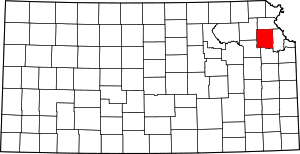 Map of Kansas highlighting Jefferson County | |
| CDP | ||
| Unincorporated communities | ||
| Townships | ||