North Warwickshire
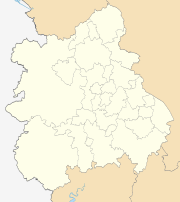
North Warwickshire is a local government district and borough in Warwickshire, England. The main town in the district is Atherstone where the offices of North Warwickshire Borough Council are based. Other significant places include Coleshill, Polesworth, Kingsbury and Hartshill. The district borders Staffordshire to the northwest, Leicestershire to the northeast, West Midlands county to the south and southwest, and the Warwickshire district of Nuneaton and Bedworth to the east.
Borough of North Warwickshire | |
|---|---|
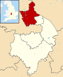 Shown within Warwickshire | |
| Sovereign state | United Kingdom |
| Constituent country | England |
| Region | West Midlands |
| Administrative county | Warwickshire |
| Founded | 1974 |
| Admin. HQ | Atherstone |
| Government | |
| • Type | Non-metropolitan borough |
| • Leadership: | Alternative - Section 31 |
| • MPs: | Craig Tracey Marcus Jones |
| • Leader | David Humphreys |
| • Executive | Conservative |
| Area | |
| • Total | 109.8 sq mi (284.3 km2) |
| Area rank | 137th |
| Population (2011 census) | |
| • Total | 62,014[1] |
| • Rank | Ranked 304th |
| Time zone | UTC+0 (Greenwich Mean Time) |
| • Summer (DST) | UTC+1 (British Summer Time) |
| Postcode | |
| ONS code | 44UB (ONS) E07000218 (GSS) |
| Ethnicity | 97.8% White (95.9% White British) 1.1% Asian 0.7% Mixed 0.2% Black 0.1% Other [2] |
| Website | northwarks.gov.uk |
The North Warwickshire district was created on 1 April 1974 by a merger of the Atherstone Rural District and parts of the Meriden Rural District (the rest of which was merged into the West Midlands county).
North Warwickshire is a mostly rural area with several small towns. The area historically had a large coal mining industry, but this has almost died out. The district is relatively remote from the rest of Warwickshire, as the county is almost split in two by the West Midlands Boroughs of Solihull and Coventry.
The boundaries of North Warwickshire are similar to those of the North Warwickshire parliamentary constituency. However the constituency also includes the town of Bedworth. The local MP is Craig Tracey.
In 2007 the Conservatives took overall control of the Borough Council for the first time since the creation of the council within its current boundaries. The Council was retaken by Labour in 2011.
It borders the Warwickshire district of Nuneaton and Bedworth to the east, the county of Leicestershire to the northeast, Staffordshire to the northwest, and the West Midlands to the south and southwest.
Parishes and settlements
Settlements in North Warwickshire include:
- Ansley, Arley, Astley, Atherstone, Austrey
- Baddesley Ensor, Baxterley, Bentley, Birchmoor, Blythe End
- Caldecote, Coleshill, Corley, Curdworth
- Dordon
- Fillongley, Furnace End
- Gilson, Great Packington, New Grendon, Old Grendon
- Hartshill, Heath Whitacre, Hurley, Hurley Common
- Kingsbury
- Lea Marston, Little Packington
- Mancetter, Maxstoke, Merevale, Middleton, Moxhull
- Nether Whitacre, Newton Regis, No Man's Heath
- Over Whitacre
- Polesworth
- Seckington, Shustoke, Shuttington,
- Warton, Water Orton, Whitacre Heath, Wiggins Hill, Wishaw, Wood End (near Kingsbury), Wood End (Near Fillongley)
For a list of wards in North Warwickshire by population see here
Local election results 1973-2011
As of August 2018, the party composition was as follows:[3]
| Party | Number of councillors |
|---|---|
| Conservative | 22 |
| Labour | 13 |
Historically, local election results have fallen like this:
| Election year | Conservative | Labour | Liberal Democrats | Ratepayers | Independent | Note |
|---|---|---|---|---|---|---|
| 2015 | 22 | 13 | 0 | 0 | 0 | |
| 2011 | 17 | 18 | 0 | 0 | 0 | |
| 2007 | 21 | 14 | 0 | 0 | 0 | |
| 2003 | 15 | 16 | 4 | 0 | 0 | Boundary Changes in effect |
| 1999 | 9 | 22 | 2 | 0 | 1 | |
| 1995 | 4 | 29 | 0 | 0 | 1 | |
| 1973 | 8 | 19 | 0 | 2 | 4 |
Parties
The Borough is a very marginal seat between the Conservatives and Labour. Within the Borough, Polesworth East, Dordon, and Wood End are considered Labour safe seats, and Fillongley, Water Orton, Newton Regis and Curdworth are considered safe Conservative seats.
See also
References
- Release Edition Reference Tables. Ons.gov.uk (17 December 2012). Retrieved on 17 July 2013.
- http://www.ons.gov.uk/ons/rel/census/2011-census/key-statistics-for-local-authorities-in-england-and-wales/rft-table-ks201ew.xls
- Councillors by political party, North Warwickshire Borough Council. Retrieved 19 April 2015.