North Grenville
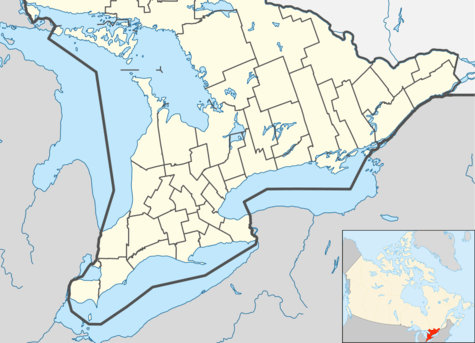
North Grenville is a township in eastern Ontario, Canada, in the United Counties of Leeds and Grenville on the Rideau River. It is located just south of Ottawa in Canada's National Capital Region.
North Grenville | |
|---|---|
| Municipality of North Grenville | |
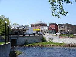
.jpg) Kemptville bridge | |
 North Grenville | |
| Coordinates: 44°58′N 75°39′W | |
| Country | Canada |
| Province | Ontario |
| County | Leeds and Grenville |
| Formed | January 1, 1998 |
| Government | |
| • Type | Township |
| • Mayor | Nancy Peckford |
| • Federal riding | Leeds—Grenville—Thousand Islands and Rideau Lakes |
| • Prov. riding | Leeds—Grenville—Thousand Islands and Rideau Lakes |
| Area | |
| • Land | 352.18 km2 (135.98 sq mi) |
| Population (2016)[1] | |
| • Total | 16,451 |
| • Density | 46.7/km2 (121/sq mi) |
| Time zone | UTC−05:00 (EST) |
| • Summer (DST) | UTC−04:00 (EDT) |
| Area code(s) | 613 |
| Website | www.northgrenville.ca |
It was established on January 1, 1998, through the amalgamation of Oxford-on-Rideau Township, South Gower Township, and the Town of Kemptville. In 2003, a motion of the municipal council adopted the designation of 'municipality'.
The largest community in North Grenville is Kemptville, with a population of 3,911 in the 2016 census, up from 3,620 in the Canada 2011 Census.[2][3] It is located on the Kemptville Creek (historically South Branch of the Rideau River) approximately 56 km (35 mi) south of Ottawa, sitting midway between suburban Ottawa and the Ogdensburg–Prescott International Bridge along Highway 416.
Communities
The municipality comprises the communities of Actons Corners, Bedell, Bishops Mills, Burritts Rapids (the oldest community on the Rideau River), East Oxford, Heckston, Hutchins Corners, Kemptville, McReynolds, Millars Corners, Newmanville, Oxford Mills, Oxford Station, Pattersons Corners, Peltons Corners, Sabourins Crossing, Schipaville, Swan Crossing and Van Allens. The administrative offices of the municipality are located in Kemptville.
Demography
| Canada census – North Grenville community profile | |||
|---|---|---|---|
| 2016 | 2011 | 2006 | |
| Population: | 16,451 (+9.1% from 2011) | 15,085 (6.2% from 2006) | 14,198 (4.5% from 2001) |
| Land area: | 352.18 km2 (135.98 sq mi) | 352.14 km2 (135.96 sq mi) | 350.14 km2 (135.19 sq mi) |
| Population density: | 46.7/km2 (121/sq mi) | 42.8/km2 (111/sq mi) | 40.5/km2 (105/sq mi) |
| Median age: | 45.6 (M: 44.9, F: 46.2) | 40.7 (M: 40.3, F: 41.0) | |
| Total private dwellings: | 6,658 | 5,908 | 5,513 |
| Median household income: | $77,279 | $69,187 | |
| References: 2016[4] 2011[5] 2006[6] earlier[7] | |||
See also
References
- "North Grenville census profile". 2016 Census of Population. Statistics Canada. Retrieved 2017-11-05.
- Statistics Canada. 2016.
- "Kemptville census profile". 2011 Census of Population. Statistics Canada. Retrieved 2012-02-15.
- "2016 Community Profiles". 2016 Canadian Census. Statistics Canada. February 21, 2017. Retrieved 2019-06-02.
- "2011 Community Profiles". 2011 Canadian Census. Statistics Canada. July 5, 2013. Retrieved 2012-02-15.
- "2006 Community Profiles". 2006 Canadian Census. Statistics Canada. March 30, 2011. Retrieved 2012-02-15.
- "2001 Community Profiles". 2001 Canadian Census. Statistics Canada. February 17, 2012.
External links
Places adjacent to North Grenville | ||||||||||
|---|---|---|---|---|---|---|---|---|---|---|
| ||||||||||