North Fork Payette River
The North Fork Payette River is a river in western Idaho in the United States. It flows about 113 miles (182 km) southwards from the Salmon River Mountains to near Banks, where it empties into the Payette River, a tributary of the Snake River. It drains a watershed of 912 square miles (2,360 km2), consisting of mountains and forests, and valleys filled with large lakes and wetlands.
| North Fork Payette River | |
|---|---|
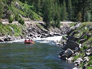 Rafters running rapids on the North Fork Payette River near the mouth | |
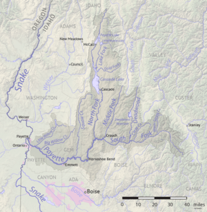 Map of the Payette River watershed including the North Fork | |
| Location | |
| Country | United States |
| State | Idaho |
| Region | Valley County, Boise County |
| Cities | McCall, Cascade, Banks |
| Physical characteristics | |
| Source | Confluence of Trail Creek and Cloochman Creek |
| • location | Northwest of Diamond Ridge, Valley County |
| • coordinates | 45°10′47″N 115°59′37″W[1] |
| • elevation | 6,083 ft (1,854 m) |
| Mouth | Payette River |
• location | Banks, Boise County |
• coordinates | 44°05′06″N 116°06′57″W[1] |
• elevation | 2,825 ft (861 m) |
| Length | 113 mi (182 km), North-south[2] |
| Basin size | 912 sq mi (2,360 km2)[3] |
| Discharge | |
| • location | Banks, ID[4] |
| • average | 1,299 cu ft/s (36.8 m3/s)[4] |
| • minimum | 36 cu ft/s (1.0 m3/s) |
| • maximum | 8,830 cu ft/s (250 m3/s) |
| Basin features | |
| River system | Snake River watershed |
| Tributaries | |
| • left | Lake Fork (Idaho), Clear Creek (Idaho), Round Valley Creek |
Course
It rises at the confluence of Trail Creek and Cloochman Creek, in a meadow in the Payette National Forest in Valley County. The river flows south into Upper Payette Lake then further south through a narrow valley into Payette Lake. The river exits from the southern end of the lake at McCall and flows southwards through Long Valley into Lake Cascade, a large reservoir formed by Cascade Dam. The Lake Fork and Gold Fork rivers join from the north and east sides of the lake.[5]
About 5 miles (8.0 km) below the Cascade Dam and the town of Cascade the North Fork reaches the end of Long Valley and enters a narrow canyon along the western side of the North Fork Range in the Boise National Forest. Paralleled by Idaho State Highway 55, it crosses into Boise County. At the county line, the canyon is more than 2,500 feet (760 m) deep. The North Fork joins with the Payette River near the village of Banks, at an elevation of 2,825 feet (861 m). From there, the Payette River flows 62 miles (100 km) further west to its confluence with the Snake River near Ontario, Oregon.[5]
References
- "North Fork Payette River". Geographic Names Information System. United States Geological Survey. 1979-06-21. Retrieved 2010-10-26.
- "North Fork Payette River Subbasin Assessment" (PDF). Idaho Department of Environmental Quality. Retrieved 2010-10-26.
- "Boundary Descriptions and Names of Regions, Subregions, Accounting Units and Cataloging Units". U.S. Geological Survey. Retrieved 2010-08-22.
- "USGS Gage #13246000 on the North Fork Payette River near Banks, ID: Water-Data Report 2009" (PDF). National Water Information System. U.S. Geological Survey. 1947–2009. Retrieved 2010-10-26.
- USGS Topo Maps for United States (Map). Cartography by United States Geological Survey. ACME Mapper. Retrieved 2010-10-26.
External links
![]()
| Authority control |
|
|---|