Norroy
Norroy is a commune in the Vosges department in Grand Est in northeastern France.
Norroy | |
|---|---|
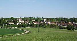 A general view of Norroy | |
.svg.png) Coat of arms | |
Location of Norroy 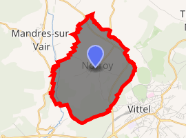
| |
 Norroy  Norroy | |
| Coordinates: 48°12′59″N 5°55′15″E | |
| Country | France |
| Region | Grand Est |
| Department | Vosges |
| Arrondissement | Neufchâteau |
| Canton | Vittel |
| Intercommunality | CC Terre d'eau |
| Government | |
| • Mayor (2008–2014) | Annette Marchal |
| Area 1 | 7.22 km2 (2.79 sq mi) |
| Population (2017-01-01)[1] | 222 |
| • Density | 31/km2 (80/sq mi) |
| Time zone | UTC+01:00 (CET) |
| • Summer (DST) | UTC+02:00 (CEST) |
| INSEE/Postal code | 88332 /88800 |
| Elevation | 323–454 m (1,060–1,490 ft) |
| 1 French Land Register data, which excludes lakes, ponds, glaciers > 1 km2 (0.386 sq mi or 247 acres) and river estuaries. | |
Despite an official name change, it still sometimes appears in official documents named as Norroy-sur-Vair.
Inhabitants are called Nogarésiens.
Geography
Norroy is positioned 5 kilometres (3 mi) to the north-west of Vittel on a plateau that separates the Rivers Vair and Petit Vair (Little Vair). The highest point, in the south of the commune, is at 454 meters in the Châtillon Woods (Bois de Châtillon).
History
The commune of Norroy-sur-Vair [2] contained a command post which must have been given to the Knights Templar by the Count of Vaudémont. In the later medieval period revenues from the commune were split, two thirds going to the Dukes of Lorraine and one third to the Templar Commander at Robécourt. In 1751 the commune was subject to the bailiwick of Bourmont, and it was part of the Lamarche District under the post-revolution administrative structure in place between 1790 and 1800.
In terms of church administration, Norroy-sur-Vair was an annex to the parish of Mandres-sur-Vair, under the care of the presbytery at Bulgnéville.
See also
References
- "Populations légales 2017". INSEE. Retrieved 6 January 2020.
- Archives départementales Archived 2011-07-17 at the Wayback Machine
| Wikimedia Commons has media related to Norroy (Vosges). |
| Authority control |
|
|---|