Normandykes
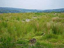
Normandykes (Grid Reference: NO 830994)[1] is the site of a Roman marching camp 1 mile (1.6 km) to the southwest of Peterculter, City of Aberdeen, Scotland.[2][3] The near-rectangular site, measuring approximately 860 by 510 metres (940 by 560 yd), covers about 106 acres (43 ha) of the summit and eastern slopes of a hill overlooking the River Dee and the B9077 road further south.[4] Aerial photographs for Normandykes have been archived between 1947 and 1976.[5] The camp is about 6 miles (10 km), or less than half a day's march, north of the Raedykes camp. It is possible that the actual route taken would have entailed one day's march, over a route likely chosen to avoid the Red Moss, a virtually uncrossable bog near the present day village of Netherley. Normandykes was first excavated in the year 1935 by Richmond and MacIntyre;[6] construction is thought to date to the Antonine or Severan periods.
The site is designated a scheduled ancient monument.[7]
See also
References
- Landranger 45, Stonehaven and Banchory, 1:50000 (2004); Explorer 406 Aberdeen and Banchory, 1:25000, United Kingdom Ordnance Survey Map
- Temporary Marching Camp: Normandykes, Peterculter, Grampian (2004) Archived 2009-10-06 at the Wayback Machine
- St. Joseph, J.K., Air Reconnaissance of North Britain, J.R.S. xli (1951) p. 65
- Crawford, O.G.S.Topography of Roman Scotland North of the Antonine Wall, Cambridge, England pp. 110-2 (1949)
- RCAHMS Site Record for Normandykes Hilton; Oldtown; Peterculter Photographs (2004)
- RCAHMS Archaeology Notes: Normandykes (2003)
- Historic Environment Scotland. "Normandykes,Roman camp (SM2478)". Retrieved 26 February 2019.
Settlements and places of interest in Kincardine and Mearns, Aberdeenshire | ||
|---|---|---|
| Primary settlements |  | |
| Other settlements | ||
| Places of interest | ||