Newer Volcanics Province
The Newer Volcanics Province is a geological area which is a volcanic field, formed by the East Australia hotspot across south-eastern Australia. It covers an area of 15,000 square kilometres (5,800 sq mi), with over 400 small shield volcanoes and volcanic vents. The area contains the youngest volcanoes in Australia.[1][2]

The volcanoes date from the Late-Pleistocene to Holocene ages. The area is characterised by flat lava flows, forming a plain above which rise numerous small scoria cones, tuff rings, and maars. The most recent eruptions in the region took place at Mount Schank and Mount Gambier, estimated about 5000 years BP, when several maars were formed and associated lava flows spread around the cones.[3][2]
Volcanoes within the province include:
- Mount Schank
- Mount Napier
- Mount Gambier (including Blue Lake)
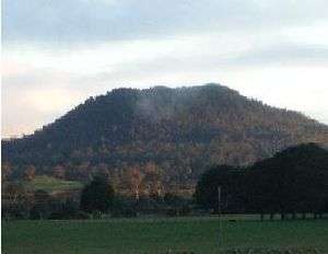
- Tower Hill
- Mount Elephant
- Mount Eccles (Budj Bim), with associated Tyrendarra lava flow
- Mount Leura
- Mount Noorat
- Mount Buninyong
- Lake Bullen Merri
- Lake Purrumbete
- Red Rock
References
- Rawlinson, N.; Sandiford, M. (2012). "Illuminating the upper mantle beneath the Newer Volcanics province, southeast Australia, using seismic body wave tomography". AGU Fall Meeting Abstracts. Bibcode:2012AGUFM.T31B2594R.CS1 maint: uses authors parameter (link)
- "Newer Volcanics Province". Volcano Discovery. Retrieved 18 March 2020.
- Selina, Kate; Green, Webber (27 May 2016). "Long time to wait for Australia's next volcanic eruption". ABC News. Retrieved 18 March 2020.
Further reading
- Boyce, J. (2013). "The Newer Volcanics Province of southeastern Australia: a new classification scheme and distribution map for eruption centres". Australian Journal of Earth Sciences. Informa UK Limited. 60 (4): 449–462. doi:10.1080/08120099.2013.806954. ISSN 0812-0099.
- Eruption Points of the Newer Volcanic Province(Agriculture Victoria)
- Newer Volcanics Province (Smithsonian Institution)