New Mexico State Road 518
State Road 518 (NM 518) is a 72.899-mile-long (117.320 km) state highway in northern New Mexico. NM 518 begins as a continuation of 7th Street at Mills Avenue near Interstate 25 (I-25) in Las Vegas. It proceeds north to La Cueva where the road turns northwest at its junction with NM 442. The road continues northwest through Mora and eventually ends in Ranchos de Taos at its northern terminus at NM 68. The segment of NM 518 between Mora and Ranchos de Taos passes through the rugged terrain of the Sangre de Cristo Mountains and provides access to Carson National Forest where camping, fishing, skiing, and other recreational opportunities are available.

Telephoto view of the high Sangre de Cristo Range from the overlook between mileposts 60 and 61, on US Hill, February 2007.
| ||||
|---|---|---|---|---|
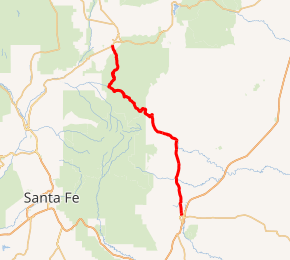
NM 518 highlighted in red | ||||
| Route information | ||||
| Maintained by NMDOT | ||||
| Length | 72.899 mi[1] (117.320 km) | |||
| Tourist routes | Part of High Road to Taos Scenic Byway between NM 75 and NM 68 | |||
| Major junctions | ||||
| South end | 7th Street / Mills Ave. in Las Vegas | |||
| North end | ||||
| Location | ||||
| Counties | San Miguel, Mora, Taos | |||
| Highway system | ||||
| ||||

Major intersections
| County | Location | mi[2] | km | Destinations | Notes |
|---|---|---|---|---|---|
| San Miguel | Las Vegas | 0.000 | 0.000 | 7th Street | Continuation beyond Mills Avenue to I-25 Bus. to I-25 |
| Mills Avenue | Southern terminus; former routing of NM 329 | ||||
| Sapello | 10.862 | 17.481 | Southern terminus of NM 94 | ||
| Mora | Buena Vista | 21.052 | 33.880 | Western terminus of NM 161 | |
| La Cueva | 23.852 | 38.386 | Southern terminus of NM 442 | ||
| Mora | 29.043 | 46.740 | Northern terminus of NM 94 | ||
| 29.221 | 47.027 | Southern terminus of NM 434 | |||
| | 36.164 | 58.200 | Southern terminus of NM 121 | ||
| Taos | | 57.037 | 91.792 | Eastern terminus of NM 75 | |
| Ranchos de Taos | 72.899 | 117.320 | Northern terminus | ||
| 1.000 mi = 1.609 km; 1.000 km = 0.621 mi | |||||
See also

References
- "NMDOT State Routes" (PDF). New Mexico Department of Transportation. Retrieved 2008-03-26.
- "TIMS Road Segments by Posted Route/Point with AADT Info; NM, NMX-Routes" (PDF). New Mexico Department of Transportation. April 3, 2013. pp. 5–7. Retrieved October 20, 2018.
This article is issued from Wikipedia. The text is licensed under Creative Commons - Attribution - Sharealike. Additional terms may apply for the media files.