New England water resource region
The New England water resource region is one of 21 major geographic areas, or regions, in the first level of classification used by the United States Geological Survey to divide and sub-divide the United States into successively smaller hydrologic units. These geographic areas contain either the drainage area of a major river, or the combined drainage areas of a series of rivers.[1][2] The New England region, which is listed with a 2-digit hydrologic unit code (HUC) of 01, has an approximate size of 73,753 square miles (191,020 square kilometers), and consists of 11 sub-regions, which are listed with the 4-digit HUCs 0101 through 0111.
| New England water resource region | |
|---|---|
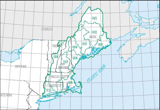 The New England region, with its 11 4-digit sub-region hydrologic unit boundaries. | |
| Location | |
| Countries | Canada, United States |
| States | Includes all of Maine, New Hampshire and Rhode Island, and parts of Connecticut, Massachusetts, New York, and Vermont |
| Physical characteristics | |
| Basin size | 73,753 sq mi (191,020 km2) |
This region includes the drainage within the United States that ultimately discharges into: (a) the Bay of Fundy; (b) the Atlantic Ocean within and between the states of Maine and Connecticut; (c) Long Island Sound north of the New York-Connecticut state line; and (d) the Riviere St. Francois, a tributary of the Saint Lawrence River. The region includes all of Maine, New Hampshire and Rhode Island, and parts of Connecticut, Massachusetts, New York, and Vermont.[3]
List of water resource subregions
| Subregion HUC[4] | Subregion Name[4] | Subregion Description[3] | Subregion Location[4] | Subregion Size[4] | Subregion Map |
|---|---|---|---|---|---|
| 0101 | St. John subregion | The St. John River Basin within the United States. | Located in Maine. | 14,092 sq mi (36,500 km2) |  HUC0101 |
| 0102 | Penobscot subregion | The Penobscot River Basin. | Located in Maine. | 8,616 sq mi (22,320 km2) |  HUC0102 |
| 0103 | Kennebec subregion | The Kennebec River Basin, including part of Merrymeeting Bay. | Located in Maine. | 5,895 sq mi (15,270 km2) |  HUC0103 |
| 0104 | Androscoggin subregion | The Androscoggin River Basin, including part of Merrymeeting Bay. | Located in Maine and New Hampshire. | 3,527 sq mi (9,130 km2) |  HUC0104 |
| 0105 | Maine Coastal subregion | The coastal drainage and associated waters from the Maine-New Brunswick international boundary to Cape Small, Maine, including the St. Croix River Basin within the United States. | Located in Maine. | 11,558 sq mi (29,940 km2) |  HUC0105 |
| 0106 | Saco subregion | The coastal drainage and associated waters from Cape Small, Maine to the Merrimack River Basin Boundary. | Located in Maine, New Hampshire, and Massachusetts. | 4,809 sq mi (12,460 km2) |  HUC0106 |
| 0107 | Merrimack subregion | The Merrimack River Basin. | Located in Massachusetts and New Hampshire. | 5,007 sq mi (12,970 km2) |  HUC0107 |
| 0108 | Connecticut subregion | The Connecticut River Basin. | Located in Connecticut, Massachusetts, New Hampshire, and Vermont. | 11,265 sq mi (29,180 km2) |  HUC0108 |
| 0109 | Massachusetts-Rhode Island Coastal subregion | The coastal drainage and associated waters from the Merrimack River Basin boundary to and including the Pawcatuck River Basin. | Located in Connecticut, Massachusetts, and Rhode Island. | 4,439 sq mi (11,500 km2) |  HUC0109 |
| 0110 | Connecticut Coastal subregion | The coastal drainage into Long Island Sound from the Pawcatuck River Basin boundary to and including the Byram River Basin, excluding the Connecticut River Basin, and including Long Island Sound north of the New York-Connecticut state line. | Located in Connecticut, Massachusetts, New York, and Rhode Island. | 4,545 sq mi (11,770 km2) |  HUC0110 |
| 0111 | St. Francois subregion | The Riviere St. Francois Basin within the United States. | Located in Vermont. | 590 sq mi (1,500 km2) |  HUC0111 |
See also
- List of rivers in the United States
- Water resource region
References
- "Science in Your Watershed - Locate Your Watershed". USGS. Retrieved 2016-10-12.

- "Hydrologic Unit Maps". USGS. Retrieved 2016-10-12.
- "Boundary Descriptions and Names of Regions, Subregions, Accounting Units and Cataloging Units". USGS. Retrieved 2016-10-12.
- McManamay RA, Bevelhimer MS, Kao SC, Yaxing W, Martinez-Gonzalez M, Samu N (2013). "National Hydropower Asset Assessment Environmental Attribution". USGS-Oak Ridge National Laboratory. Retrieved 2016-10-12.