Nevada State Route 705
State Route 705 (SR 705) is a short 0.928-mile-long (1.493 km) state highway in Douglas County, Nevada. The route follows a portion of Clear Creek Road just south of Carson City. The route was once part of the Lincoln Highway, forming a major travel link between Carson City and Lake Tahoe. SR 705 was designated in 2000, and was only truncated once.
| ||||
|---|---|---|---|---|
| Clear Creek Road | ||||
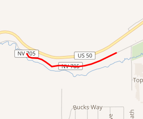
SR 705 highlighted in red | ||||
| Route information | ||||
| Maintained by NDOT | ||||
| Length | 0.928 mi[1] (1.493 km) | |||
| Existed | 2000–present | |||
| History | Road established by 1928; Was Lincoln Highway & US 50 ca. 1930s-1950s | |||
| Major junctions | ||||
| West end | Clear Creek Road south of Carson City | |||
| East end | Clear Creek Road south of Carson City | |||
| Highway system | ||||
| ||||

Route description
SR 705 begins in Douglas County at the Carson City/Douglas County line southwest Carson City on Clear Creek Road (shown on some maps as "Old Clear Creek Road"), just north of Clear Creek. The state-maintained highway follows Clear Creek Road eastward along the course of Clear Creek for nearly one mile. The road bends around desert hills, and the route (SR 705) ends at the Douglas County/Carson City line, but the road continues eastward to an intersection with U.S. Route 395 (US 395).[1][2] SR 705 is currently not directly connected to the remainder of Nevada's state highway system.[1]
History
Early travel
Trails connecting Lake Tahoe with the Comstock Lode mining region near Carson City had been established in the mid-1800s, with the first wagon road route through Kings Canyon to the north having been constructed by November 1863. This route was eventually selected to become part of the Lincoln Highway and, later, a branch of SR 3.[3]
The advent of the automobile greatly changed this region of Nevada. From 1927 to 1928, aided by both state and forest highway funding, a graded two-lane road was constructed along the corridor of Clear Creek to connect Carson City to Spooner Summit, just east of Glenbrook on the eastern shore of Lake Tahoe.[4][5] The Clear Creek Road replaced the former Kings Canyon route as the major road to Lake Tahoe in 1928,[3] and was subsequently selected as a later realignment of the Lincoln Highway.[6] Clear Creek Road later became part of US 50, but was bypassed in the 1950s by the current four-lane alignment located a short distance to the north.[4][5]
The route today
Clear Creek Road remained largely unchanged since it was established. The Nevada Department of Transportation initially designated SR 705, from the current western terminus east to a Bureau of Indian Affairs water diversion box in Carson City, by January 11, 2000.[7] By the beginning of 2006, the short portion with Carson City had been removed from state maintenance, resulting in the current highway segment in Douglas County.[8]
Major intersections
The entire route is in Douglas County.
| Location | mi[1] | km | Destinations | Notes | |
|---|---|---|---|---|---|
| | 0.000 | 0.000 | Clear Creek Road | Continuation beyond western terminus | |
| | 0.928 | 1.493 | Clear Creek Road | Continuation beyond eastern terminus | |
| 1.000 mi = 1.609 km; 1.000 km = 0.621 mi | |||||
See also


References
- Nevada Department of Transportation (January 2017). "State Maintained Highways of Nevada: Descriptions and Maps". Retrieved 2017-01-17.
- Google (November 11, 2012). "Overview of SR 705" (Map). Google Maps. Google. Retrieved November 11, 2012.
- Massey, Peter; Wilson, Jeanne; Titus, Angela (2008). "22–Kings Canyon Trail". Nevada Trails Western Region: Backroads & 4-Wheel Drive Trails. Adler Publishing. pp. 161–165. ISBN 1-930193-15-7. Retrieved November 11, 2012.
- "Spooner Summit: Nevada Historical Marker 261". State Historic Preservation Office. Nevada Department of Conservation and Natural Resources. Retrieved November 11, 2012.
- Sebesta, Paul. "261: Spooner Summit". Nevada-Landmarks. Retrieved November 11, 2012.
- "Official Map of the Lincoln Highway". The Lincoln Highway Association. Lincoln Highway Association. Retrieved November 11, 2012.
- Nevada's State Maintained Highways: Descriptions, Index and Maps. Nevada Department of Transportation. 2001.
- Nevada's State Maintained Highways: Descriptions, Index and Maps. Nevada Department of Transportation. 2006.
| Wikimedia Commons has media related to Nevada State Route 705. |