Nettetal
Nettetal is a municipality in the district of Viersen, North Rhine-Westphalia, Germany. It is situated in the Lower Rhine region.
Nettetal | |
|---|---|
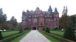 Krickenbeck Castle | |
 Coat of arms | |
Location of Nettetal within Viersen district 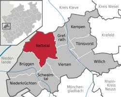 | |
 Nettetal 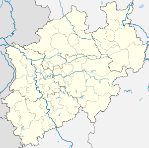 Nettetal | |
| Coordinates: 51°19′N 6°17′E | |
| Country | Germany |
| State | North Rhine-Westphalia |
| Admin. region | Düsseldorf |
| District | Viersen |
| Founded | 1970 |
| Subdivisions | 6 boroughs |
| Government | |
| • Mayor | Christian Wagner (CDU) |
| • Governing parties | CDU |
| Area | |
| • Total | 84 km2 (32 sq mi) |
| Elevation | 38 m (125 ft) |
| Population (2018-12-31)[1] | |
| • Total | 42,493 |
| • Density | 510/km2 (1,300/sq mi) |
| Time zone | CET/CEST (UTC+1/+2) |
| Postal codes | 41334 |
| Dialling codes | 02153, 02157, 02158 |
| Vehicle registration | VIE, KK |
| Website | www.nettetal.de |
Geography
Nettetal is not a town itself, but a federation of villages that have developed around the river Nette, Peat removal formed most of the twelve lakes. It is right in the middle of the Maas-Schwalm-Nette Nature Park and on the border with the Netherlands, approximately 20 km north-west from Mönchengladbach and 10 km south-east from Venlo. There are 6 spatially divided boroughs.
The small river Nette, broad forest and heath areas as well as twelf lakes make Nettetal a central resort in the Maas-Schwalm-Nette Nature Park.
Boroughs
Nettetal consists of the following boroughs (2017 population[2] in brackets):
- Lobberich (14,154)
- Kaldenkirchen (10,000)
- Breyell (8,395)
- Hinsbeck (4,846)
- Schaag (3,827)
- Leuth (1,800)
Nettetal's main charter divides the municipality into 6 boroughs (Ortschaften). Lobberich and Kaldenkirchen are the biggest boroughs, since both have been autonomous municipalities in the past. Together with the former townships Breyell, Hinsbeck and Leuth they are the founding boroughs of Nettetal. Schaag was a part of Breyell before it became a borough of its own in 1995.
Lakes
Nettetal features 12 lakes with an overall area of 179 hectare (ha).
Fed by the Nette:
- Kleiner Breyeller See: 5.3 ha
- Großer Breyeller See: 9.2 ha
- Nettebruch: 13.2 ha
- Windmühlenbruch: 6 ha
- Ferkensbruch: 4.5 ha
- Kleiner de Wittsee: 4.5 ha
- Großer de Wittsee: 22.5 ha
- Schrolik: 15.5 ha
- Poelvennsee: 24.5 ha
At the Renne:
- Hinsbecker Bruch: 37.5 ha
- Glabbacher Bruch: 36 ha
Fed by the Königsbach:
- Kälberweide: 5 ha
History
Nettetal was founded on January 1st, 1970 when the former townships Leuth, Breyell, Hinsbeck and former towns/cities Lobberich and Kaldenkirchen were merged.
Since it was impossible to combine all coats of arms into one, a new coat of arm was introduced in 1971. It shows a water lily before a blue blackground, symbolizing the predominant nature and variety of lakes. Five water lily leaves represent the founding cities and townships of Nettetal.
Sights
- The Castle Krickenbeck from the 11th century and its park are well known in the region. Today it is used as a conference center.
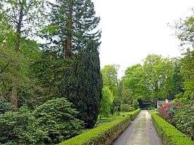
- The Sequoiafarm Kaldenkirchen is an arboretum, it has more than 400 varieties of trees and interesting ground flora and is part of the "Protected area of Maas-Schwalm-Nette".
- The 100 km long Fietsallee am Nordkanal, an international Long-distance cycling route, runs through Nettetal.
- The premium hiking trail Galgenvenn was awarded as 2nd best hiking trail in Germany (2016).
International relations
Nettetal is twinned with:
Notable people
- Leo Anton Karl de Ball (1853–1916), German-Austrian astronomer
- Werner Jaeger (1888–1961), classicist
- Michael Hardt (born 1951), designer
- Sascha Lappessen (born 1970), DJ and bandleader
- Tuğrul Erat (born 1992), Azerbaijani footballer
External links
References
- "Bevölkerung der Gemeinden Nordrhein-Westfalens am 31. Dezember 2018" (in German). Landesbetrieb Information und Technik NRW. Retrieved 10 July 2019.
- "Daten & Fakten | Stadt Nettetal". www.nettetal.de (in German). Retrieved 2018-06-27.
Towns and municipalities in Viersen (district) | ||
|---|---|---|
Coat of arms of Viersen district | ||
| Authority control |
|
|---|