Nendeln
Nendeln is a village of Liechtenstein, located in the municipality of Eschen.
Nendeln | |
|---|---|
Village | |
 | |
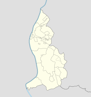 Nendeln Locator map of Nendeln in Liechtenstein | |
| Coordinates: 47°12′N 9°33′E | |
| Country | |
| Electoral district | |
| Municipality | |
| Elevation | 450 m (1,480 ft) |
| Population (2003) | |
| • Total | 1,357[1] |
| Time zone | UTC+1 (CET) |
| • Summer (DST) | UTC+2 (CEST) |
| Postal code | 9485 |
| Area code(s) | (+423) ... |
History
Prior to the establishment of the village, the Roman Empire had a presence here. Villas from that time period have been excavated at Nendeln.[2]
Geography
The village is located in north-central Liechtenstein, on the main road Schaan-Schaanwald that links the country with Buchs (Switzerland) and Feldkirch (Austria). Closer villages to Nendeln are Schaanwald, Mauren, Eschen and Planken.[3]
Transport
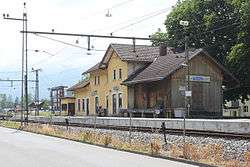
As rail transport, Nendeln counts a railway station on the Feldkirch-Buchs line.
References
- (in German) 2003 population statistics of Eschen municipality
- Baedeker, Karl (1891). The eastern Alps : including the Bavarian highlands, the Tyrol, Salzkammergut, Styria, Carinthia, Carniola, and Istria : handbook for travellers. London: Dulau. p. 265.
- 240046176 Nendeln on OpenStreetMap
External links
![]()
Villages of Liechtenstein (hamlets of the 11 municipalities) | |||
|---|---|---|---|
| Authority control |
|
|---|
This article is issued from Wikipedia. The text is licensed under Creative Commons - Attribution - Sharealike. Additional terms may apply for the media files.