Nelson, Missouri
Nelson is a city in Saline County, Missouri, United States. The population was 192 at the 2010 census.
Nelson, Missouri | |
|---|---|
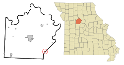 Location of Nelson, Missouri | |
| Coordinates: 38°59′43″N 93°1′55″W | |
| Country | United States |
| State | Missouri |
| County | Saline |
| Area | |
| • Total | 0.33 sq mi (0.85 km2) |
| • Land | 0.33 sq mi (0.85 km2) |
| • Water | 0 sq mi (0 km2) |
| Elevation | 673 ft (205 m) |
| Population | |
| • Total | 192 |
| • Estimate (2016)[3] | 190 |
| • Density | 580/sq mi (230/km2) |
| Time zone | UTC-6 (Central (CST)) |
| • Summer (DST) | UTC-5 (CDT) |
| ZIP code | 65347 |
| Area code(s) | 660 |
| FIPS code | 29-51500[4] |
| GNIS feature ID | 0723162[5] |
History
Nelson was platted in 1887, and named after the Nelson family, the original owners of the town site.[6] A post office called Nelson has been in operation since 1887.[7]
Geography
Nelson is located at 38°59′43″N 93°1′55″W (38.995330, -93.031928).[8]
According to the United States Census Bureau, the city has a total area of 0.33 square miles (0.85 km2), all land.[1]
Demographics
| Historical population | |||
|---|---|---|---|
| Census | Pop. | %± | |
| 1890 | 383 | — | |
| 1900 | 468 | 22.2% | |
| 1910 | 480 | 2.6% | |
| 1920 | 639 | 33.1% | |
| 1930 | 337 | −47.3% | |
| 1940 | 334 | −0.9% | |
| 1950 | 297 | −11.1% | |
| 1960 | 126 | −57.6% | |
| 1970 | 230 | 82.5% | |
| 1980 | 248 | 7.8% | |
| 1990 | 181 | −27.0% | |
| 2000 | 212 | 17.1% | |
| 2010 | 192 | −9.4% | |
| Est. 2016 | 190 | [3] | −1.0% |
| U.S. Decennial Census[9] | |||
2010 census
As of the census[2] of 2010, there were 192 people, 78 households, and 51 families living in the city. The population density was 581.8 inhabitants per square mile (224.6/km2). There were 91 housing units at an average density of 275.8 per square mile (106.5/km2). The racial makeup of the city was 91.7% White, 3.1% African American, 0.5% Native American, 0.5% Asian, and 4.2% from two or more races. Hispanic or Latino of any race were 1.0% of the population.
There were 78 households of which 35.9% had children under the age of 18 living with them, 48.7% were married couples living together, 11.5% had a female householder with no husband present, 5.1% had a male householder with no wife present, and 34.6% were non-families. 28.2% of all households were made up of individuals and 11.5% had someone living alone who was 65 years of age or older. The average household size was 2.46 and the average family size was 2.84.
The median age in the city was 40.8 years. 26% of residents were under the age of 18; 6.8% were between the ages of 18 and 24; 24.5% were from 25 to 44; 32.9% were from 45 to 64; and 9.9% were 65 years of age or older. The gender makeup of the city was 50.0% male and 50.0% female.
2000 census
As of the census[4] of 2000, there were 212 people, 83 households, and 58 families living in the city. The population density was 640.5 people per square mile (248.0/km²). There were 100 housing units at an average density of 302.1 per square mile (117.0/km²). The racial makeup of the city was 93.40% White, 6.13% African American, and 0.47% from two or more races.
There were 83 households out of which 28.9% had children under the age of 18 living with them, 53.0% were married couples living together, 9.6% had a female householder with no husband present, and 30.1% were non-families. 16.9% of all households were made up of individuals and 8.4% had someone living alone who was 65 years of age or older. The average household size was 2.55 and the average family size was 2.95.
In the city the population was spread out with 24.1% under the age of 18, 5.7% from 18 to 24, 33.0% from 25 to 44, 25.0% from 45 to 64, and 12.3% who were 65 years of age or older. The median age was 38 years. For every 100 females there were 98.1 males. For every 100 females age 18 and over, there were 96.3 males.
The median income for a household in the city was $28,214, and the median income for a family was $31,250. Males had a median income of $24,219 versus $16,500 for females. The per capita income for the city was $12,886. About 6.3% of families and 11.8% of the population were below the poverty line, including 22.2% of those under the age of eighteen and 10.5% of those sixty five or over.
References
- "US Gazetteer files 2010". United States Census Bureau. Archived from the original on 2012-01-25. Retrieved 2012-07-08.
- "U.S. Census website". United States Census Bureau. Retrieved 2012-07-08.
- "Population and Housing Unit Estimates". Retrieved June 9, 2017.
- "U.S. Census website". United States Census Bureau. Retrieved 2008-01-31.
- "US Board on Geographic Names". United States Geological Survey. 2007-10-25. Retrieved 2008-01-31.
- "Saline County Place Names, 1928–1945". The State Historical Society of Missouri. Archived from the original on June 24, 2016. Retrieved December 22, 2016.
- "Post Offices". Jim Forte Postal History. Retrieved 22 December 2016.
- "US Gazetteer files: 2010, 2000, and 1990". United States Census Bureau. 2011-02-12. Retrieved 2011-04-23.
- "Census of Population and Housing". Census.gov. Retrieved June 4, 2015.
External links
- Historic maps of Nelson in the Sanborn Maps of Missouri Collection at the University of Missouri
Municipalities and communities of Saline County, Missouri, United States | ||
|---|---|---|
| Cities | 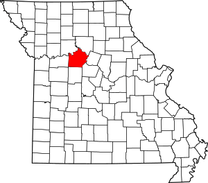 Map of Missouri highlighting Saline County | |
| Villages | ||
| Townships | ||
| Unincorporated communities | ||
| Ghost towns | ||
| Footnotes | ‡This populated place also has portions in an adjacent county or counties | |