Neighbourhoods in Chilliwack
Chilliwack is a city made up of several amalgamated villages and communities.[1] The urban core has a decidedly North-South axis bisected by the Trans-Canada Highway. The city is bounded in north by the Fraser River, in the east by the Eastern Hillsides, in the south by the Canada-U.S. border, and in the west by the Vedder Canal.[2]
Northside
Northside, also referred to as Chilliwack Proper Village West, covers the area from the Trans-Canada Highway in the south, to the Fraser River in the north, and includes the following communities.
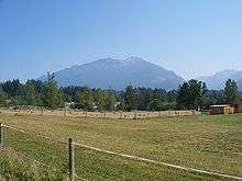
Camp River
A picturesque, rural farming community at the North-East extreme of the city on Fairfield Island.
Cheam
Downtown Chilliwack
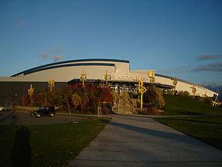
Also known as Chilliwack Proper, is the historical urban centre of the city. Several cultural attractions, such as the Prospera Centre, Chilliwack Cultural Centre and the Eagle Landing Shopping Centre are located there, as well as key government buildings, such as City Hall, FVRD offices, and the Provincial Court of British Columbia.
East Chilliwack
A rural-suburban community located between Downtown Chillwack to the west, and Rosedale to the east.
Fairfield Island
A mainly suburban and residential neighbourhood, and the northernmost community within the city boundaries.
Rosedale
A rural-suburban community in the north-eastern part of the city. This small community is based alongside the Fraser River. It serves as a base for many tourists, both in summer and winter. The hills and valleys of British Columbia are popular skiing, snowboarding and dogsledding locations. In summer, rockclimbing and whitewater rafting are the primary activities in the Fraser Valley.
Southside
Atchelitz
Atchelitz is a rural community within the City of Chilliwack in the Eastern Fraser Valley region of British Columbia, Canada.[3] It is located southwest of the city core, to the north of the Vedder Canal.
Atchelitz Pioneer Village, located within Atchelitz community, is a little antique town operating as a museum, located right next to Tourism Chilliwack and Chilliwack Heritage Museum. It is run entirely by volunteers from Atchelitz Threshermen’s Association. Atchelitz' collectors are mainly focused on collecting and restoring steam and gasoline stationary engines, steam and gasoline tractors and machinery used for farming. [4][5][6]
Chilliwack River Valley
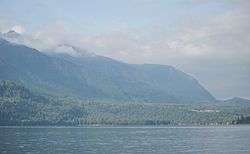
Stretching 47km from Chilliwack Lake to the Vedder Crossing, the valley contains an eclectic mix of homes, vacation properties, campgrounds, industry (logging/mining), and Crown Land. It is increasingly popular as an outdoor recreation destination, featuring hiking, camping, fishing, whitewater sports, off-road motoring, and birding.
Columbia Valley
Cultus Lake Park
Cultus Lake is a lake, associated community and provincial park in the Fraser Valley region of British Columbia, Canada. It is the source of the Sweltzer River. The lake itself is warm, and the area has become a popular recreation destination with ample opportunities for fishing, water skiing, wind surfing, and hiking. Cultus Lake is located 11 kilometers (6.8 mi) south of the Chilliwack River, near the city of Chilliwack and approximately 80 kilometers (50 mi) east of Vancouver.[7] In 1950, Cultus Lake became a Provincial park of British Columbia. Cultus Lake covers an area of 656 hectares, evenly on either side of the lake. At one time the lake had a sawmill and booming ground until it became a provincial park in the 1950s.
Greendale
}
Popkum (Not considered part of Chilliwack but part of the Fraser Valley)
At the eastern extreme of the city limits, and a popular tourist destination and way station for travellers on the Trans-Canada Highway. Attractions include Bridal Veil Falls and The Falls Golf and Country Club.
Promontory
Ryder Lake
Ryder Lake is a small, sub-alpine, farming-based community located in Chilliwack, British Columbia, situated on Mount Thom to the west of Lookout Ridge.[8] A post office operated here from 1926 to 1940 Notable features in Ryder Lake include a former small elementary school and small fire hall.
The community is located east of Promontory. It is home to a great variety of wildlife and is a popular destination for hiking. The community is named after the lake of the same name.[9] The small lake is situated on private property and cannot be seen from the road because of fencing and trees.
Sardis
Sardis is the urban core of the southside and a popular shopping destination.
Vedder Crossing

A vibrant and burgeoning community on the north bank of the Vedder River, home to the Canada Education Park and the Twin Rinks ice hockey arena.
Yarrow
The village was first settled by Mennonites in the late 1920s, following the draining of Sumas Lake and the reclamation of the former lake bed for agriculture. It is at the foot of the Skagit Range of the Cascade Mountains on the Vedder River, near the latter's confluence with the Fraser, which traverses the Lower Mainland, of British Columbia. The Lower Mainland Ecoregion is part of the Pacific Maritime Ecozone. The village of Yarrow lies between Vedder Mountain to the south and Sumas Mountain to the northwest. The climate is temperate with most of the precipitation falling in the winter months as rain. The summer is warm and relatively dry. The fertile upper Fraser Valley supports the growth of many varieties of fruit, vegetables and herbs. Yarrow's economy is thus primarily agricultural and includes dairy farms and field crops (blueberries, corn, cole crops and hay).
Yarrow Ecovillage
The Ecovillage is a member-designed community that aims to achieve a more socially, ecologically and economically sustainable way of life. The Ecovillage's master plan for the 10-hectare (25-acre) former dairy farm, foresaw three main legal entities: An 8-hectare (20-acre) organic farm, a 31-unit multigenerational cohousing community (later increased to 33 units), and a mixed-use development with just under 2800 m2 (30,000 sf) of commercial space, a 17-unit senior cohousing community and a learning centre.[10]
References
- "Community of Villages". chilliwackmuseum.ca. Chilliwack Museum and Archives. Archived from the original on 9 March 2014. Retrieved 17 March 2014.
- "BC Geographical Names: Chilliwack". gov.bc.ca. Government of BC. Retrieved 17 March 2014.
- BC Names entry "Atchelitz (community)"
- "Atchelitz Threshermen's Association (ATA)". Atchelitz Threshermens Association - ATA. Retrieved 2020-03-21.
- "Atchelitz Threshermens Association Pioneer Village". Tourism Chilliwack. Retrieved 2020-03-21.
- "Fun Things To Do in Chilliwack: Little Antique Houses of Atchelitz". PerfectDayToPlay Blog. 2019-08-16. Retrieved 2020-03-21.
- British Columbian Tourist Attractions Archived 2006-06-19 at the Wayback Machine
- BC Names/GeoBC "Ryder Lake (community)"
- BC Names/GeoBC entry "Ryder Lake (lake)"
- McCammant, K and Durrett, C. (2011). Creating Cohousing: Building Sustainable Communities. Chapter 26, "Yarrow Ecovillage: Cohousing as a Building Block to the Ecovillage," 206-212. Gabriola Island, British Columbia: New Society Publishers.