National Route 27 (Costa Rica)
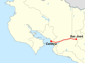
National Primary Route 27, or just Route 27 (Spanish: Ruta Nacional Primaria 27, or Ruta 27) is a National Road Route of Costa Rica, its official name is Carretera Nacional José María Castro Madriz (José María Castro Madriz National Road),[1] also known as Autopista San José-Caldera (San José-Caldera Highway), is a route which connects the Greater Metropolitan Area to Caldera Port and the Pacific coast of the country.[2]
| ||||
|---|---|---|---|---|
| Ruta Nacional Primaria 27 | ||||
| José María Castro Madriz National Road Carretera Nacional José María Castro Madriz San José-Caldera Highway Autopista San José-Caldera | ||||
 | ||||
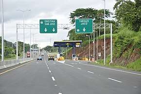 Toll booth in Route 27 | ||||
| Route information | ||||
| Maintained by Globalvía Infraestructuras S.A. | ||||
| Length | 77 km (48 mi) | |||
| Existed | 2010–present | |||
| History | Opened in January 27, 2010 | |||
| Major junctions | ||||
| East end | ||||
El Coyol arterial road Turrúcares arterial road Atenas arterial road Balsa arterial road Escobal Hacienda Vieja | ||||
| West end | ||||
| Location | ||||
| Provinces | San José, Alajuela, Puntarenas | |||
| Highway system | ||||
National Road Network of Costa Rica
| ||||

Description
The design of the route dates from 1978, due to financial, political and bad management, it was opened thirty two years later, in several segments since 2005.[3]
The route begins next to the National Gymnasium in Mata Redonda district of San José canton, and continues west with four lanes, two in each direction, then from the loop road Route 39 to the toll booths in Escazú there are six lanes, three in each direction. Afterwards until Ciudad Colón there are four lanes, two in each direction, then only two lanes, one in each direction until the junction with Route 23 at Caldera Port in Puntarenas.
In San José province the route covers San José canton (Hospital, Mata Redonda districts), Escazú canton (San Rafael district), Santa Ana canton (Pozos, Uruca, Piedades, Brasil districts).
In Alajuela province the route covers Alajuela canton (San Antonio, Guácima, San Rafael, Turrúcares districts), Atenas canton (Jesús, Concepción, Escobal districts), Orotina canton (Orotina, El Mastate, Hacienda Vieja, Coyolar, La Ceiba districts).
In Puntarenas province the route covers Esparza canton (Caldera district).
In the holidays, the route becomes mostly a single direction highway eastwards from Caldera to San José in advantage of the returning beach goers coming back to the Greater Metropolitan Area.
History
In 1973, the José Figueres Ferrer administration decided to relocate the main Pacific port from Puntarenas to Caldera bay, making it evident that with a new highway connecting Ciudad Colón with Orotina, the new port would be only 80 km from San José, just an hour away.
In the mid 1970s, a preliminary design was drafted along the left (south) margin of the Virilla River (crossing towns such as El Rodeo, Piedras Negras and San Pablo de Turrubares) that seemed the most economical, passing through low-cost uncultivated lands. But over time the elected design was along the right (north) margin of the river (La Guácima, Turrúcares, Concepción), which had more expensive lands for expropriation.
The financial crisis in the early 1980s prevented further progress. However, in 1986 in the first government of Óscar Arias (1986-1990), US$40 million was obtained from the Inter-American Development Bank (IDB) to build the new road, although that administration finished without the loan being used. The same happened during the four-year period of Rafael Ángel Calderón Fournier (1990-1994). The opportunity didn't take advantage of those resources, and the IDB withdrew upon expiration of the loan period of use. The country uselessly paid US$3 million in interest.
At the end of the 1990s, without available financing, private concession was considered, but it was necessary for the government to acquire more than half of the required lands, an opportunity that the owners took in their advantage to inflate the prices. Although they were reported to the Public Prosecutor's Office in 1997, it was considered that such abuse is not criminalized in the Criminal Code. In total, it took about twenty years to acquire the land for this work of public interest. Several major bridges where constructed in 1997 with US$25 million borrowed from Venezuela. They were completed and inaugurated in the administration of Miguel Ángel Rodríguez (1998-2002), and the road, which did not yet exist, was also inaugurated and named.
The administration of Abel Pacheco (2002-2006) tendered the project by concession in 2004, and only one bid was received, from the Argentine company José Cartellone, which soon went bankrupt. The company tried to give the contract to Lavalin of Canada, but a year later withdrew claiming that the right of way was not yet available. When the second administration of Óscar Arias (2006-2010) arrived, the concession was negotiated directly with the Spanish company Autopistas del Valle, a winner of the San José-San Ramón highway since 2005, but it did not obtain immediate financing.
Finally, a sister consortium of Autopistas del Valle, called Autopistas del Sol, was hired to build Ciudad Colón-Orotina and also improve La Sabana-Ciudad Colón and Orotina-Caldera, which was already built, and raised the cost to US$120 million. The company claimed that the road would cost 3 times more (US$370 million) than budgeted. The road infrastructure was mostly completed until almost five years after initial works, without penalizing the delay. Similarly, the same road designs were used more than 30 years ago, already obsolete by then, because changing them involved a larger budget in jobs and expropriations.
The toll collection charged to the concessionaire began prematurely, with the route unfinished. Users were very critical of the amount to be paid and the location of the collection booths. In addition, the concessionaire managed to get the contract to include a guarantee of "minimum annual income", so that if the toll collected does not reach the expected amount, the government will have to pay the remainder.
With such controversies and without having been completed in its entirety, the road officially opened on January 27, 2010,[4] with an intense and continuous period of construction since January 9, 2008.
Since then, the highway was delivered and managed by Autopistas del Sol with a public works concession contract (Law 7762 of Costa Rica) for its maintenance, for an extended period of 25 years. Together with the Constructora San José-Caldera, the concessionaire worked overtime to finish as soon as possible.
In March 2014 Autopistas del Sol sold most of its shares to the Spanish company Globalvía Infraestructuras S.A., with which the latter assumed control of the concession.
To carry out the work, technologies such as hydro-demolition, rubblizing, the use of carbon fiber and the manufacture and extension of asphalts were implemented. On average, the trip to Caldera can be done in just over an hour, when it would take up to two hours by using Route 1.
Future widening
As the 1970s design proved to be obsolete upon opening due to having only one lane in each direction in most of the route, there have been plans to widen the design by adding and addendum to the concession contract, which is still in discussion as of September 2019 with plans to finish the required paperwork before the end of 2021.[5][6]
References
- Madrigal, Rebeca (28 July 2014). "Ruta 27 es llamada por su nombre 13 años después de "bautizarla"". Retrieved 23 September 2019.
- "GeoPortal". Ministerio de Obras Públicas y Transporte de Costa Rica. Retrieved 28 May 2020.
- Loaiza N., Vanessa (12 February 2005). "Avanza negociación para construir la vía a Caldera". Retrieved 23 September 2019.
- Vindas, Leticia (27 January 2010). "Luego de 32 años hoy se inauguró carretera a Caldera". Retrieved 23 September 2019.
- Recio, Patricia (23 September 2019). "Gobierno pediría autorización el próximo año para ampliar ruta 27". Retrieved 23 September 2019.
- Recio, Patricia (22 September 2019). "Concesiones alista plan de proyectos para dejar en manos privadas y analiza la venta de activos". Retrieved 23 September 2019.