National Register of Historic Places listings in Stephenson County, Illinois
This is a list of the National Register of Historic Places listings in Stephenson County, Illinois.
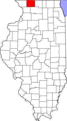
Location of Stephenson County in Illinois
This is intended to be a complete list of the properties and districts on the National Register of Historic Places in Stephenson County, Illinois, United States. Latitude and longitude coordinates are provided for many National Register properties and districts; these locations may be seen together in a map.[1]
There are 16 properties and districts listed on the National Register in the county, and two former listings.
- This National Park Service list is complete through NPS recent listings posted June 19, 2020.[2]
Current listings
| [3] | Name on the Register | Image | Date listed[4] | Location | City or town | Description |
|---|---|---|---|---|---|---|
| 1 | John H. Addams Homestead |  John H. Addams Homestead |
April 17, 1979 (#79000871) |
425 N. Mill St. 42°23′26″N 89°38′16″W |
Cedarville | |
| 2 | AF and AM Lodge 687, Orangeville |  AF and AM Lodge 687, Orangeville |
May 9, 2003 (#03000354) |
203 W. High St. 42°28′06″N 89°38′44″W |
Orangeville | |
| 3 | James Bruce Round Barn | 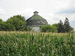 James Bruce Round Barn |
February 23, 1984 (#84001157) |
S of Freeport 42°15′07″N 89°38′57″W |
Freeport | |
| 4 | Central House |  Central House |
May 20, 1999 (#99000585) |
210 W. High St. 42°28′09″N 89°38′47″W |
Orangeville | |
| 5 | Charles Fehr Round Barn | 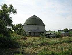 Charles Fehr Round Barn |
February 23, 1984 (#84001152) |
NE of Orangeville 42°29′46″N 89°31′20″W |
Orangeville | |
| 6 | Gerald Harbach Round Barn |  Gerald Harbach Round Barn |
February 23, 1984 (#84001155) |
US 20 42°19′40″N 89°44′04″W |
Eleroy | |
| 7 | Chris Jensen Round Barn | February 23, 1984 (#84001150) |
11723 W. Galena Rd. 42°23′30″N 89°50′06″W |
Lena | Demolished[5] | |
| 8 | Kellogg's Grove | 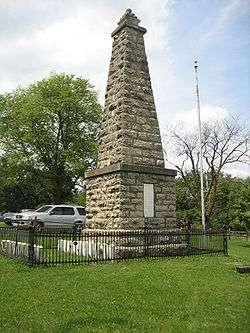 Kellogg's Grove |
June 23, 1978 (#78001191) |
SE of Kent 42°17′46″N 89°53′13″W |
Kent | |
| 9 | Lena Water Tower |  Lena Water Tower |
February 20, 1997 (#97000034) |
201 Vernon St. 42°22′49″N 89°49′41″W |
Lena | |
| 10 | Dennis Otte Round Barn | 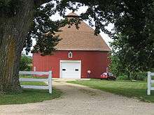 Dennis Otte Round Barn |
February 23, 1984 (#84001164) |
E of Eleroy 42°20′01″N 89°44′16″W |
Eleroy | |
| 11 | People's State Bank |  People's State Bank |
August 20, 2004 (#04000868) |
300 W. High St. 42°28′15″N 89°38′49″W |
Orangeville | |
| 12 | William Ritzman House |  William Ritzman House |
October 27, 2000 (#00000949) |
10715 IL 26 N 42°27′33″N 89°38′30″W |
Orangeville | |
| 13 | Soldiers' Monument | 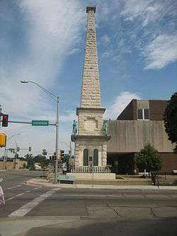 Soldiers' Monument |
June 1, 1998 (#98000461) |
15 N. Galena Ave. 42°17′52″N 89°37′19″W |
Freeport | |
| 14 | Stephenson County Courthouse |  Stephenson County Courthouse |
January 17, 1974 (#74002284) |
Courthouse Sq. 42°17′53″N 89°37′19″W |
Freeport | Demolished; the building shown is the new courthouse, which was built on the site of the old one |
| 15 | Oscar Taylor House |  Oscar Taylor House |
May 11, 1984 (#84001165) |
1440 S. Carroll Ave. 42°17′04″N 89°36′54″W |
Freeport | |
| 16 | Union House |  Union House |
May 11, 2000 (#00000472) |
207 W. High St. 42°28′06″N 89°38′45″W |
Orangeville |
Former listing
| [3] | Name on the Register | Image | Date listed | Date removed | Location | City or town | Summary |
|---|---|---|---|---|---|---|---|
| 1 | Clyde Leek Round Barn | February 23, 1984 (#84001161) | December 8, 1995 | N Dakota Rd. |
Dakota | ||
| 2 | Freeport City Hall |  Freeport City Hall |
June 7, 2016 (#16000329) | January 2, 2020 | 230 W. Stephenson St. 42°17′51″N 89°37′24″W |
Freeport |
See also
| Wikimedia Commons has media related to National Register of Historic Places in Stephenson County, Illinois. |
References
- The latitude and longitude information provided in this table was derived originally from the National Register Information System, which has been found to be fairly accurate for about 99% of listings. Some locations in this table may have been corrected to current GPS standards.
- "National Register of Historic Places: Weekly List Actions". National Park Service, United States Department of the Interior. Retrieved on June 19, 2020.
- Numbers represent an ordering by significant words. Various colorings, defined here, differentiate National Historic Landmarks and historic districts from other NRHP buildings, structures, sites or objects.
- The eight-digit number below each date is the number assigned to each location in the National Register Information System database, which can be viewed by clicking the number.
- Travis, Dale. "Illinois Round Barns List". Retrieved June 18, 2015.
| Topics | |
|---|---|
| Lists by state |
|
| Lists by insular areas | |
| Lists by associated state | |
| Other areas | |
| Related | |
| |
This article is issued from Wikipedia. The text is licensed under Creative Commons - Attribution - Sharealike. Additional terms may apply for the media files.