Natick Center station
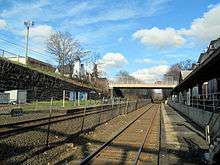
Natick Center (formerly Natick) is an MBTA Commuter Rail station in Natick, Massachusetts served by the Framingham/Worcester Line. The station, located below grade in a wide cut adjacent to North Main Street (MA-27), has two low-level side platforms serving the line's two tracks. Natick Center station is not accessible; the low platforms do not support level boarding, and passage to street level is via staircases only. The busiest non-accessible station on the system, it is planned to receive a major renovation and modernization from December 2019 to mid-2022.
Natick Center | |||||||||||||
|---|---|---|---|---|---|---|---|---|---|---|---|---|---|
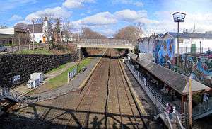 Natick Center station in April 2016 | |||||||||||||
| Location | 1 Walnut Street, Natick, Massachusetts | ||||||||||||
| Coordinates | 42°17′09″N 71°20′50″W | ||||||||||||
| Line(s) | Worcester Main Line | ||||||||||||
| Platforms | 2 side platforms | ||||||||||||
| Tracks | 2 | ||||||||||||
| Connections | |||||||||||||
| Construction | |||||||||||||
| Parking | 71 spaces (Town permit required) 4 accessible spaces | ||||||||||||
| Other information | |||||||||||||
| Fare zone | 4 | ||||||||||||
| History | |||||||||||||
| Opened | c. 1839 | ||||||||||||
| Rebuilt | 1897, c. 1962; December 2019 to mid-2022 | ||||||||||||
| Previous names | Natick (until January 12, 2015) | ||||||||||||
| Traffic | |||||||||||||
| Passengers (2018) | 736 (weekday average boardings)[1] | ||||||||||||
| Services | |||||||||||||
| |||||||||||||
| |||||||||||||
Natick Center station is primarily used by those walking from nearby neighborhoods. A small lot with 71 spaces, owned by the town, is adjacent to the station; a town permit is needed to park. West Natick station, with a larger lot and daily pay spaces, opened two miles to the west in 1982 to serve park and ride commuters; most trains serve both stations.
History
Early history
The Boston & Worcester Railroad, extending outwards from Boston, was completed Natick in August 1834.[2] The line was double tracked through Natick in 1839, by which time a station had been established.[2][3] Two other stations were located in Natick: Lake Crossing (at Bacon Street on the border with Wellesley to the east) and Walkerville (at Speen Street to the west).[4] Neither lasted long into the 20th century.
The 3.87-mile (6.23 km) Saxonville Branch opened from Natick to the Saxonville section of Framingham on July 6, 1846, with through trains to Boston. Although branch ridership was never high, these trains were timed to allow commuting from Natick for the first time.[2] Stations on the branch included Felchville (at Fisher Street), Cochituate (at Commonwealth Road on the Natick/Framingham border), and Saxonville.[3][5]
Longfellow station
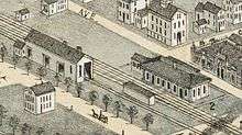
The B&A extended third and fourth tracks from Riverside to Lake Crossing in 1894, and through Natick in 1896. During that construction, the line was realigned north (primarily to eliminate a sharp curve west of downtown) and lowered into a wide cut through downtown Natick to eliminate grade crossings with a number of streets.[6] (Middlesex Avenue and the Middlesex Path now lie on the original alignment.) A new granite and brownstone station designed by Alexander Wadsworth Longfellow, Jr., a student of H.H. Richardson (who had designed nine stations for the B&A in the 1880s), opened in 1897.[7] The New York Central Railroad acquired the line in 1900.[3]
Decline
The lightly used Saxonville Branch never saw more than three daily round trips; in 1936, passenger service was discontinued. A "bus" – the Saxonville station agent's car – ran to Saxonville until 1943.[8] Freight service continued until the 1980s; the Cochituate Rail Trail is now being built on the right-of-way.[3]
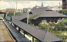
The line was reduced to two tracks through Natick in 1962.[3] Around that time, a large building was built over the 1897 station, with the old station becoming the wine cellar of a liquor store. The original inbound canopy remains for use by the public, though the only station facilities are two bare platforms.[7] The inbound side of the station is supported by the rear wall of the liquor store, decorated with a colorful mural of the Downtown Natick area. A second station serving the town opened at West Natick in 1982 to provide additional parking.[9] In October 1997, Natick was identified as a possible site for a parking garage. The plan was cancelled because of concerns over the financial viability of the garage.[10]
Name change and new station
Natick Center station is not accessible; the low platforms do not support level boarding, and passage to street level is via staircases only. Inbound ridership in 2018 was 736 passengers, making Natick Center the second-busiest non-accessible station on the MBTA Commuter Rail system.[1] Flooding of the inbound track and platform during heavy rains is a recurrent problem.[11][12] In January 2013, the Town of Natick formed a formal committee to advise the town on developing plans for a rebuilt station.[13]
In June 2014, conceptual plans were unveiled for upgrades to make the station fully handicapped accessible with high-level platforms and accessible routes from street level.[14] The rebuilt station was to replace the existing side platforms with an island platform for cost and operational reasons, with a third track (to allow freight trains and express passenger trains to pass stopped local trains) able to fit into the wide existing trench as well. The proposal would provide better integration of the station with the surrounding streets, including a deck over parts of the trench between Washington Street and Main Street.[15] One option with the new station and a pedestrian-only deck was projected to cost $26.0 million, while a deck incorporating a bus loop would add $17 million more.[16]
In July 2014, the MBTA agreed to the town's request to change the station's name as part of a larger rebranding of the Natick Center area.[14] Online maps were changed shortly thereafter, and on January 12, 2015, the station was officially renamed as Natick Center.[17] In March 2016, $4 million for completing design of the station was included in a draft 2017–2021 MBTA capital plan.[18]
After further MBTA review, the island platform design was replaced with two side platforms in 2017. The third center track may not be added as part of initial construction, but space will be left between the two main tracks to add it in the future.[19] The estimated $36.5 million contract was put out to bid in August 2019.[20] A $36.1 million contract was awarded on November 4, 2019.[21] The 30-month construction period began in March 2020.[22] Demolition of the canopy took place in May 2020.[23]
References
- Central Transportation Planning Staff (2019). "2018 Commuter Rail Counts". Massachusetts Bay Transportation Authority.
- Humphrey, Thomas J. & Clark, Norton D. (1985). Boston's Commuter Rail: The First 150 Years. Boston Street Railway Association. pp. 21–25. ISBN 9780685412947.
- Karr, Ronald Dale (1995). The Rail Lines of Southern New England. Branch Line Press. pp. 278–283. ISBN 0942147022.
- "Natick". County Atlas of Middlesex Massachusetts. F.W. Beers & Co. 1875 – via Ward Maps.
- "Felchville". County Atlas of Middlesex Massachusetts. F.W. Beers & Co. 1875 – via Ward Maps.
- Healey, John (August 1990). "WRITTEN HISTORICAL AND DESCRIPTIVE DATA" (PDF). HAER No. MA-108: Boston & Albany Railroad: Marion Street Bridge. Historic American Engineering Record, National Park Service.
- Roy, John H. Jr. (2007). A Field Guide to Southern New England Railroad Depots and Freight Houses. Branch Line Press. pp. 302–03. ISBN 9780942147087.
- Humphrey, Thomas J. & Clark, Norton D. (1986). Boston's Commuter Rail: Second Section. Boston Street Railway Association. pp. 39, 61. ISBN 9780938315025.
- Belcher, Jonathan. "Changes to Transit Service in the MBTA district" (PDF). NETransit.
- "INDEPENDENT STATE AUDITOR'S REPORT ON CERTAIN ACTIVITIES OF THE MASSACHUSETTS BAY TRANSPORTATION AUTHORITY: JULY 1, 1996 TO JULY 31, 2001" (PDF). Auditor of the Commonwealth. April 3, 2002.
- Rosen, Andy; Roberts, Sarah (August 21, 2015). "Heavy rains cause commuter rail delays, snarl commute". Boston Globe.
- Henrich, Michael (30 September 2015). "Storm causes flooding on MBTA Commuter Rail tracks". FOX25 Boston. Archived from the original on 30 September 2015.
- "MBTA Station Advisory Committee". Town of Natick. Archived from the original on 30 September 2015.
- Benson, Brian (4 August 2014). "MBTA backs Natick Center station name change". MetroWest Daily News. Retrieved 12 January 2015.
- McMahon Associates; URS (15 June 2014). "Natick Center MBTA Commuter Rail Station: Feasibility Study and Conceptual Design for Upgrades (Draft)". Town of Natick. Archived from the original on 30 September 2015.
- McMahon Associates; URS (18 June 2014). "Implementation Framework". Natick Center MBTA Commuter Rail Station Improvements Implementation Plan (Draft). Town of Natick. Archived from the original on 30 September 2015.
- Arsenault, Charlene (12 January 2015). "MBTA Commuter Rail Station Now 'Natick Center Station'". Natick Patch. Archived from the original on 30 September 2015.
- Benson, Brian (26 March 2016). "MBTA eyes money for Natick Center station design". Metrowest Daily News. Retrieved 26 March 2016.
- Benson, Brian (December 17, 2017). "Natick Center train station design progressing". Metrowest Daily News.
- "Notice to Bidders" (PDF). Massachusetts Bay Transportation Authority. August 30, 2019. Archived (PDF) from the original on September 6, 2019.
- "FMCB Approves Contract for Major Improvements at Natick Center Station" (Press release). Massachusetts Bay Transportation Authority. November 4, 2019.
- Malachowski, Jeff (April 8, 2020). "Long-awaited $40 million reconstruction of the Natick Center commuter rail station is underway". Metrowest Daily News.
- "Natick Center Station Accessibility Improvements". Massachusetts Bay Transportation Authority. June 2020. Archived from the original on June 24, 2020.
External links
| Wikimedia Commons has media related to Natick Center station. |