Nara, Mali
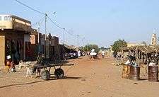
Nara (Bambara: ߣߊߙߊ tr. Nara) is a town and rural commune in the Koulikoro Region of southwestern Mali. The town is the administrative center of the Nara Cercle. It is 37 km south of the Mauritanian border and 292 km north-northeast of the Malian capital, Bamako. The rural commune covers an area of 1300 square kilometers and includes the town and 16 surrounding villages.[3] In the 2009 census the commune had a population of 19,793.[1]
Nara | |
|---|---|
Commune and town | |
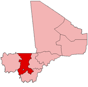
 Nara Location in Mali | |
| Coordinates: 15°10′5″N 7°17′15″W | |
| Country | |
| Region | Koulikoro Region |
| Cercle | Nara Cercle |
| Area | |
| • Total | 1,300 km2 (500 sq mi) |
| Population (2009 census)[1] | |
| • Total | 19,793 |
| • Density | 15/km2 (39/sq mi) |
| [2] | |
| Time zone | UTC+0 (GMT) |
Nara
References
- Resultats Provisoires RGPH 2009 (Région de Koulikoro) (PDF) (in French), République de Mali: Institut National de la Statistique.
- Common and Fundamental Operational Datasets Registry: Mali, United Nations Office for the Coordination of Humanitarian Affairs, archived from the original on 2012-12-14, retrieved 2012-08-23. commune_mali.zip (Originally from the Direction Nationale des Collectivités Territoriales, République du Mali)
- Communes de la Région de Koulikoro (PDF) (in French), Ministère de l’administration territoriale et des collectivités locales, République du Mali, archived from the original (PDF) on 2012-03-09.
External links
- Plan de Sécurité Alimentaire Commune Rurale de Nara 2007-2011 (PDF) (in French), Commissariat à la Sécurité Alimentaire, République du Mali, USAID-Mali, 2007, archived from the original (PDF) on 2012-09-17.
This article is issued from Wikipedia. The text is licensed under Creative Commons - Attribution - Sharealike. Additional terms may apply for the media files.