Nain Singh Rawat
Nain Singh Rawat (21 October 1830 – 1 February 1882),[1][2] was one of the first of the late 19th century Indian explorers (pundits) who explored the Himalayas for the British. He came from the Johar Valley in Kumaon. He surveyed the trade route through Nepal to Tibet, determined for the first time the location[3] and altitude of Lhasa in Tibet, and surveyed a large section of the Brahmaputra. He walked "1,580 miles, or 3,160,000 paces, each counted."[3]
Nain Singh Rawat | |
|---|---|
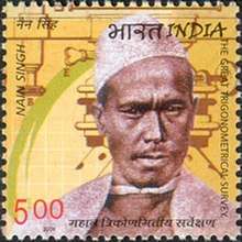 Nain Singh Rawat on a 2004 stamp of India | |
| Born | 21 October 1830 Milam Village |
| Died | 1 February 1882 |
| Nationality | Indian |
| Occupation | Asian explorer |
Early life
Rai Bahadur Nain Singh Rawat was born to Lata Burha in 1830 in Milam village, a Bhotia village at the foot of the Milam glacier where the river Goriganga originates in the valley of Johar now on India-China border in present day Pithoragarh district of Uttarakhand state of India. The Rawats ruled over the Johar Valley, during the reign of Chand dynasty in Kumaon; this was followed by the Gorkha rule. In 1816 the British defeated the Gorkhas but maintained a policy of non-interference and friendship towards the Johar Bhotias. The famous Bhotia explorers mostly belong to the village of Johar.
After leaving school, Nain Singh helped his father. He visited different centres in Tibet with him, learned the Tibetan language, customs and manners and became familiar with the Tibetan people. This knowledge of Tibetan language and local customs and protocol came in handy in Nain Singh's work as a "spy explorer". Due to the extreme cold conditions, Milam and other villages of the upper Johar valley are inhabited only for a few months from June to October. During this time the men used to visit Gya'nyima, Gartok and other markets in Western Tibet.
During his secret survey of Tibet, Nain Singh was the first non-Tibetan to visit many legendary areas of Tibet, including the Thok Jalung goldfields on 26 August 1867.[4] He would later say that Thok Jalung was the coldest place he had ever visited.[5]
Nain Singh was a cousin of Krishna Singh Rawat, another famous pundit explorer.[6]
Legacy
On 27 June 2004, an Indian postage stamp featuring Nain Singh[7] was issued commemorating his role in the Great Trigonometric Survey of India. In 2006, Shekhar Pathak and Uma Bhatt brought out a biography of Nain Singh with three of his diaries and the RGS articles about his travels in three volumes titled Asia ki Peeth Par published by Pahar, Naini Tal.
The Nain Singh Range of mountains south of Lake Pangong are named in Nain's honour.[8]
On 21 October 2017, Google celebrated Nain Singh Rawat's 187th birthday with a Google Doodle.[2]
See also
- Shauka - Johar
- Krishna Singh Rawat
- Mani Singh Rawat
- Cartography of India
Notes
- The dates are tentative. The date of birth is based on the Google Doodle issued in 2017. The date of death is based on an obituary letter where Col. Edmund Smyth notes in April 1882 that Nain Singh died of cholera at Moradabad around the "1st of February last". He mentions an obituary in "the Times" dated 15 March.
- "Nain Singh Rawat's 187th birthday". www.google.com. Retrieved 20 October 2017.
- Wade., Davis (2012). Into the Silence : The Great War, Mallory, and the Conquest of Everest. New York: Vintage Books. p. 49. ISBN 9780375708152. OCLC 773021726.
The pundit Nain Singh, the first surveyor to fix the location of the Tibetan capital, traveled on foot from Sikkim to Lhasa and then all over central Tibet, walking 1,580 miles, or 3,160,000 paces, each counted.
- "Nain Singh Rawat's 187th birthday". Google. Alphabet. Retrieved 24 April 2019.
- Hopkirk, p. 39.
- BALASUNDARAM, M., DUBE, A. Ramgarh, 1973, "Structure, India", Nature (journal), 242, 40 doi:10.1038/242040a0.
- Trigonometrical Survey. midco.net
- Waller, p. 121.
References
| Wikimedia Commons has media related to Nain Singh Rawat. |
- Montgomerie, T. G. (1868a). "Report of a Route-Survey Made by Pundit, from Nepal to Lhasa, and Thence Through the Upper Valley of the Brahmaputra to Its Source". The Journal of the Royal Geographical Society of London. 38: 129–219. doi:10.2307/1798572. JSTOR 1798572.
- Montgomerie, T. G. (1868b). "Report of the Trans-Himalayan Explorations during 1867". Proceedings of the Royal Geographical Society of London. 13 (3): 183–198. doi:10.2307/1798932. JSTOR 1798932.
- Montgomerie, T. G. (1869). "Report of the Trans-Himalayan Explorations during 1867". The Journal of the Royal Geographical Society of London. 39: 146–187. doi:10.2307/1798550. JSTOR 1798550.
- Trotter, H. (1876). "Account of the Pundit's Journey in Great Tibet from Leh in Ladákh to Lhása, and of His Return to India viâ Assam". Proceedings of the Royal Geographical Society of London. 21 (4): 325–350. doi:10.2307/1799962. JSTOR 1799962.
- "Presentation of the Royal and Other Awards". Proceedings of the Royal Geographical Society of London. 21 (5): 397–403. 1876. JSTOR 1799720.
- Smyth, Edmund (1882). "Obituary: The Pundit Nain Singh". Proceedings of the Royal Geographical Society and Monthly Record of Geography. 4 (5): 315–317. JSTOR 1800228.
- Mason, Kenneth (1923). "Kishen Singh and the Indian Explorers". The Geographical Journal. 62 (6): 429–440. doi:10.2307/1781169. JSTOR 1781169.
- Waller, D. (2015) The Pundits: British Exploration of Tibet and Central Asia, University Press of Kentucky: Lexington, Kentucky. ISBN 9780813149042.
External links
- A Nain Singh anecdote
- Chapter from The Pundits: British exploration of Tibet and Central Asia by Derek Waller
- Nain Singh Rawat – The Indian explorer who explored the Himalayas
| Authority control |
|
|---|