Nachikatsuura
Nachikatsuura (那智勝浦町, Nachikatsuura-chō) is a town located in Higashimuro District, Wakayama Prefecture, Japan.
Nachikatsuura 那智勝浦町 | |
|---|---|
Town | |
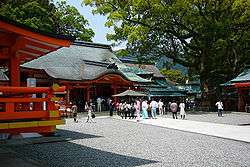 Kumano Nachi Taisha, one of World Heritage site in Japan | |
 Flag  Emblem | |
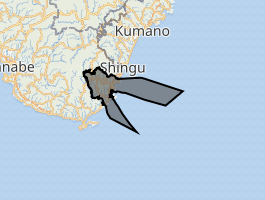
Location of Nachikatsuura in Wakayama Prefecture | |
 | |
 Nachikatsuura Location in Japan | |
| Coordinates: 33°38′N 135°56′E | |
| Country | Japan |
| Region | Kansai |
| Prefecture | Wakayama Prefecture |
| District | Higashimuro |
| Government | |
| • Mayor | Shinichi Teramoto |
| Area | |
| • Total | 183.45 km2 (70.83 sq mi) |
| Population (February 1, 2012) | |
| • Total | 17,261 |
| • Density | 94/km2 (240/sq mi) |
| Symbols | |
| • Tree | Live oak |
| • Flower | Azalea |
| Time zone | UTC+9 (JST) |
| City hall address | Oji Tsukiji 7-1-1, Nachi-Katsuura Town, Nishimuro District, Wakayama Prefecture (和歌山県西牟婁郡那智勝浦町大字築地7丁目1番1号) 649-53921 |
| Website | www |
As of February 1, 2012, the town has an estimated population of 17,261, with 8,359 households, and a density of 94.09 persons per km². The total area is 183.45 km².
Created in 1955 from four towns: Nachi, Katsuura, Ukuimura and Wakamura, by 1960 the municipality expanded to include Shimosato farther south and Otamura inland up the Ota River.
The Kumano Nachi Taisha, one of the three Kumano Shrines, is in Nachi Katsuura. These shrines form part of the "Sacred Sites and Pilgrimage Routes in the Kii Mountain Range" UNESCO World Heritage Site.
Transportation
Railway
- JR West - Kisei Main Line (Kinokuni Line)
- Ukui - Nachi - Kii-Temma - Kii-Katsuura - Yukawa - (passes through Taiji) - Shimosato - Kii-Uragami
Highways
- Nachikatsuura-Shingu Road
- Japan National Route 42
Gallery
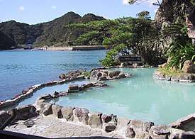 Nanki-Katsuura Onsen: Japanese open air hot spring in Nachikatsuura, Wakayama
 Pagoda in Seiganto Temple and Kumano Nachi Water Fall
External links


| Authority control |
|
|---|
This article is issued from Wikipedia. The text is licensed under Creative Commons - Attribution - Sharealike. Additional terms may apply for the media files.