Myrina, Greece
Myrina (Greek: Μύρινα) is a former municipality on the island of Lemnos, North Aegean, Greece. Since the 2011 local government reform it is part of the municipality Lemnos, of which it is a municipal unit.[2] It covers the west coast of the island, and has a land area of 82.049 square kilometres (31.679 sq mi),[3] about 17.2% of the island's area. Its municipal seat was the town of Mýrina (pop. 5,107 at the 2001 census), located in the middle of the island's west coast. The town is also the capital of Lemnos, as well as the seat of the Metropolitan (Greek Orthodox bishop) of Lemnos. In addition to the town of Myrina, the municipal unit includes the communities of Káspakas (792), Platý (785), Thános (451), and Kornós (267). The 2011 census recorded 5,711 residents in the town and 8,006 residents in the municipal unit.[1]
Myrina Μύρινα | |
|---|---|
.jpg) View of the promenade with the fortress | |
 Myrina Location within the regional unit 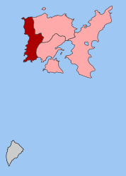 | |
| Coordinates: 39°53′N 25°04′E | |
| Country | Greece |
| Administrative region | North Aegean |
| Regional unit | Lemnos |
| Municipality | Lemnos |
| • Municipal unit | 82.0 km2 (31.7 sq mi) |
| Population (2011)[1] | |
| • Municipal unit | 8,006 |
| • Municipal unit density | 98/km2 (250/sq mi) |
| Community | |
| • Population | 5,711 (2011) |
| Time zone | UTC+2 (EET) |
| • Summer (DST) | UTC+3 (EEST) |
| Vehicle registration | MY |
The municipal unit's economically active population in 2001 was 3,007. Of them, 14.5% were employers, 12% self-employed, 65.4% wage-earners, 4.1% unpaid, auxiliary family members, and 4% did not declare line of occupation. Of the economically active population, 6.7% worked in agriculture, 4% in light manufacturing, 12.3% in construction, 8.5% in hotels & restaurants, and the rest in other lines of business (source: 2001 Census, National Statistical Service of Greece).
Climate
The climate in Lemnos is mainly Mediterranean. Winters are generally mild, but there will be a snowfall occasionally. Strong winds are a feature of the island, especially in August and in winter time, hence its nickname "the wind-ridden one" (in Greek, Ανεμόεσσα). The temperature is typically 2 to 5 degrees Celsius less than in Athens, especially in summertime.
| Climate data for Myrina | |||||||||||||
|---|---|---|---|---|---|---|---|---|---|---|---|---|---|
| Month | Jan | Feb | Mar | Apr | May | Jun | Jul | Aug | Sep | Oct | Nov | Dec | Year |
| Record high °C (°F) | 21.8 (71.2) |
22.0 (71.6) |
24.0 (75.2) |
25.8 (78.4) |
29.8 (85.6) |
34.4 (93.9) |
39.4 (102.9) |
38.8 (101.8) |
32.8 (91.0) |
31.2 (88.2) |
24.0 (75.2) |
22.2 (72.0) |
39.4 (102.9) |
| Average high °C (°F) | 12.7 (54.9) |
12.9 (55.2) |
14.9 (58.8) |
17.3 (63.1) |
21.9 (71.4) |
26.8 (80.2) |
29.0 (84.2) |
29.2 (84.6) |
26.2 (79.2) |
21.1 (70.0) |
16.3 (61.3) |
13.5 (56.3) |
20.2 (68.3) |
| Daily mean °C (°F) | 10.3 (50.5) |
10.5 (50.9) |
12.0 (53.6) |
14.1 (57.4) |
18.1 (64.6) |
23.1 (73.6) |
25.5 (77.9) |
25.6 (78.1) |
23.1 (73.6) |
18.1 (64.6) |
13.3 (55.9) |
11.3 (52.3) |
17.1 (62.8) |
| Average low °C (°F) | 7.7 (45.9) |
7.7 (45.9) |
9.6 (49.3) |
10.8 (51.4) |
14.8 (58.6) |
18.8 (65.8) |
21.7 (71.1) |
21.8 (71.2) |
19.4 (66.9) |
14.4 (57.9) |
11.1 (52.0) |
9.1 (48.4) |
13.9 (57.0) |
| Record low °C (°F) | −5.0 (23.0) |
−4.2 (24.4) |
−2.0 (28.4) |
4.0 (39.2) |
7.4 (45.3) |
12.4 (54.3) |
14.0 (57.2) |
14.8 (58.6) |
12.8 (55.0) |
8.6 (47.5) |
2.0 (35.6) |
−3.6 (25.5) |
−5.0 (23.0) |
| Average precipitation mm (inches) | 72.3 (2.85) |
44.1 (1.74) |
51.6 (2.03) |
32.3 (1.27) |
23.3 (0.92) |
21.9 (0.86) |
10.3 (0.41) |
7.5 (0.30) |
19.6 (0.77) |
35.9 (1.41) |
75.4 (2.97) |
80.2 (3.16) |
474.4 (18.68) |
| Average precipitation days (≥ 1.0 mm) | 7.5 | 6.2 | 5.2 | 4.2 | 3.4 | 2.6 | 1.2 | 1.2 | 1.6 | 3.8 | 7.0 | 8.4 | 52.3 |
| Average relative humidity (%) | 77.0 | 75.4 | 75.9 | 73.4 | 68.8 | 61.0 | 57.6 | 62.5 | 66.8 | 72.8 | 77.9 | 78.6 | 70.6 |
| Source: NOAA[4] | |||||||||||||
History
According to Herodotus, when the Chersonese on the Hellespont came under Athens' rule, Miltiades the son of Cimon came from Elaeus on the Chersonese to Lemnos where he proclaimed the Pelasgians must submit. The Hephaestians obeyed, giving up their city, but the Myrinaeans from the city Myrina would not be as easily pursued until they too submitted to Athens, thus given control of the island to Miltiades and the Athenians. (Herodotus: The Histories (ed. A. D. Godley, 1920), Cambridge. Harvard University Press. Cited February 2004 from The Perseus Project)
The ancient town also garnered notice of Pliny the Elder who wrote that the shadow of Mount Athos could be seen in the town's forum on the summer solstice.[5] Other authors of antiquity who note the town include Ptolemy[6] and Stephanus of Byzantium.[7]
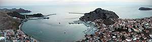
The town of Myrina
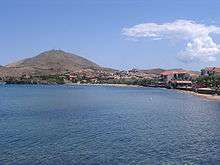

Modern day Myrina is built upon a shallow bay split into two by a promontory jutting out to sea and carrying the ruins of a Venetian castle. To the north of the promontory lies the so-called Roman Shore (in Greek, Ρωμέϊκος ΄Γιαλός), along which the Greek community had their homes during Ottoman times (prior to 1913, when Greek admiral Kountouriotis defeated the Turks and annexed Lemnos and Myrina to Greece). The name "Roman" dates to the Byzantine Empire, when Greeks were called Romans (Ρωμιοί). To the south of the promontory lies the Turkish Shore (in Greek, Τούρκικος ΄Γιαλός), along which the Turkish community similarly had their homes, before the exchange of populations between Greece and Turkey.
In 2001 the town had 3,022 regular dwellings, of which 30.4% were stone-built, and 75.6% had pitched roofs made of red tiles (source: 18.3.2001 Census, National Statistical Service of Greece).
Town quarters
Behind the fronts of the two Shores, the town is divided into 4 parts: the old town core (encompassing the aforementioned Shores), referred to as Kastro (after the Castle atop the promontory); Androni, to the north (where the women of prehistoric Lemnos are said to have drugged their men before tossing them from the cliff of Petasos (the north horn of the bay of Myrina)); Tchas (most probably from the Russian word часовой, which means sentinel, sentry, or guard, because there was a Russian garrison stationed there for a short time at the end of the 18th century; less probably from the Russian word час, which means hour), just behind the harbour area; and Nea Madetos, a new (post-1980) settlement of workers´and fishermen's houses on the hill overlooking the Turkish shore from the south. The heart of the town is the market street, running north to south, and joining the Roman Shore to the Turkish Shore. Other landmarks are the OTE (Hellenic Telecoms Organisation) square, also called the bank square because it is the hub of all bank branches of the island, halfway along the market street, and the Perivola square, behind the Roman Shore, where the Lemnos bus station is (providing bus service from Myrina to the villages and back). The Town Hall building is located in the harbour, near the Port Authority building. Myrina also boasts a good provincial hospital, in the Tchas quarter, while presently is in the process of modernising its sewage system.
Town features

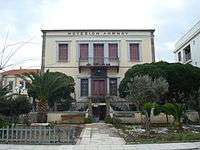
Many of the town's streets are stone-paved alleys. The Roman Shore in particular is quite beautiful, aligned as it is with stone-built houses of neoclassical design (built from the mid-19th to the early 20th century), where the island's rich Greeks lived (many of the houses are still occupied by the descendants of those Greeks, most of whom made their fortunes as businessmen in British Egypt, part of the Greek diaspora there). The archaeological museum displays numerous exhibits from the island's remote (mostly prehistoric) past. With its clean, long, and sandy beaches, and its own Castle to boot, Myrina is a tourist attraction. Visitors and locals like bathing in the Roman Shore (or the Shallow Waters (in Greek, Ρηχά Νερά) beach, adjacent to the Roman Shore on the north), and having dinner at one of the fish taverns circling the traditional harbour in the Turkish Shore, enjoying the caiques there and a view of the castle at night. During the summer Myrina holds various outside theatrical and musical events.
Notable people
- Ilias Iliou (1904–1985), politician
- Rallis Kopsidis (1929-2010), painter and writer
- Panagiotis Magdanis (1990- ), Olympic rower
References
| Wikimedia Commons has media related to Myrina (Lemnos). |
- "Απογραφή Πληθυσμού - Κατοικιών 2011. ΜΟΝΙΜΟΣ Πληθυσμός" (in Greek). Hellenic Statistical Authority.
- Kallikratis law Greece Ministry of Interior (in Greek)
- "Population & housing census 2001 (incl. area and average elevation)" (PDF) (in Greek). National Statistical Service of Greece. Archived from the original (PDF) on 2015-09-21.
- "Limnos Island Climate Normals 1961-1990". National Oceanic and Atmospheric Administration. Retrieved January 29, 2013.
- Pliny. Naturalis Historia. 4.12.23.
- Ptolemy. The Geography. 3.13.4.
- Stephanus of Byzantium. Ethnica. s.v. Μύρινα.