Mutford and Lothingland Rural District
Mutford and Lothingland Rural District was a rural district within the administrative county of East Suffolk between 1894 and 1934. It was created out of the earlier Mutford and Lothingland rural sanitary district.[1]
| Mutford and Lothingland | |
|---|---|
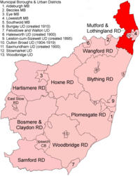 Location within East Suffolk, 1894 | |
| History | |
| • Created | 1894 |
| • Abolished | 1934 |
| • Succeeded by | Lothingland Rural District |
| Status | Rural district |
In 1904 a new Oulton Broad Urban District was created out of parts of Carlton Colville[2] and Oulton[3] parishes. Oulton Broad UD was absorbed by the Municipal Borough of Lowestoft in 1919.
In 1934, under a County Review Order, Mutford and Lothingland Rural District was abolished and its parishes transferred to the new Lothingland Rural District, apart from Gunton and some part parishes which were added to Lowestoft MB. In 1974 the area was divided between the new districts of Great Yarmouth (in Norfolk) and Waveney in Suffolk.
Statistics
| Year | Area[4] | Population [5] |
Density (pop/ha) | |
|---|---|---|---|---|
| acres | ha | |||
| 1911 | 28,171 | 11,401 | 11,184 | 0.98 |
| 1921 | 11,865 | 1.04 | ||
| 1931 | 11,996 | 1.05 | ||
Parishes
Mutford and Lothingland RD contained the parishes of Ashby, Barnby, Belton, Blundeston, Bradwell, Burgh Castle, Carlton Colville, Corton, Flixton, Fritton, Gisleham, Gunton, Herringfleet, Hopton on Sea, Kessingland, Lound, Mutford, Oulton, Pakefield, Rushmere and Somerleyton.
References
- "Mutford and Lothingland RD through time: Census tables with data for the Local Government District". A Vision of Britain through Time. GB Historical GIS / University of Portsmouth. Retrieved 10 July 2017.
- "Carlton Colville CP/AP through time: Census tables with data for the Local Government District". A Vision of Britain through Time. GB Historical GIS / University of Portsmouth. Retrieved 10 July 2017.
- "Oulton CP/AP through time: Census tables with data for the Local Government District". A Vision of Britain through Time. GB Historical GIS / University of Portsmouth. Retrieved 10 July 2017.
- "Mutford and Lothingland RD through time: Population Statistics: Area (acres)". A Vision of Britain through Time. GB Historical GIS / University of Portsmouth. Retrieved 10 July 2017.
- "Mutford and Lothingland RD through time: Population Statistics: Total Population". A Vision of Britain through Time. GB Historical GIS / University of Portsmouth. Retrieved 10 July 2017.