Muráň
Muráň (earlier Podmuráň, German: Untermuran, Hungarian: Murányalja) is a village and municipality in Revúca District in the Banská Bystrica Region of Slovakia.
Muráň | |
|---|---|
Village | |
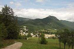 Cigánka hill (935 m) above the village, with the ruins of the Muráň Castle | |
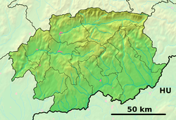 Muráň Location of Muráň in the Banská Bystrica Region  Muráň Muráň (Slovakia) | |
| Coordinates: 48°44′30″N 20°03′00″E | |
| Country | Slovakia |
| Region | Banská Bystrica |
| District | Revúca |
| First mentioned | 1321 |
| Area | |
| • Total | 103.154 km2 (39.828 sq mi) |
| Elevation | 385 m (1,263 ft) |
| Population (2005-12-31) | |
| • Total | 1,250 |
| • Density | 12/km2 (31/sq mi) |
| Postal code | 049 01 |
| Area code(s) | +421-47 |
| Car plate | RA |
| Website | www.muran.sk |
Geography
The village is located around 9 km north of Revúca, in the Muráň river valley. The Muráň Plateau is located north and west of the village, with the governing body of the Muránska planina National Park seated in the village. There is a local railway track from Plešivec (Rožňava District) ending in Muráň.
History
The village was first mentioned in 1321 as a settlement under the Muráň Castle.
External links
- Municipal website (in Slovak)
This article is issued from Wikipedia. The text is licensed under Creative Commons - Attribution - Sharealike. Additional terms may apply for the media files.