Mulberry, Ohio
Mulberry is a census-designated place (CDP) in Miami Township, Clermont County, Ohio, United States. The population was 3,323 at the 2010 census.[3]
Mulberry, Ohio | |
|---|---|
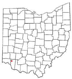 Location of Mulberry, Ohio | |
| Coordinates: 39°11′38″N 84°15′3″W | |
| Country | United States |
| State | Ohio |
| County | Clermont |
| Township | Miami |
| Area | |
| • Total | 1.6 sq mi (4.1 km2) |
| • Land | 1.6 sq mi (4.1 km2) |
| • Water | 0.0 sq mi (0.0 km2) |
| Elevation | 840 ft (256 m) |
| Population (2010) | |
| • Total | 3,323 |
| • Density | 2,090/sq mi (806.9/km2) |
| Time zone | UTC-5 (Eastern (EST)) |
| • Summer (DST) | UTC-4 (EDT) |
| FIPS code | 39-53270[2] |
| GNIS feature ID | 1065082[1] |
History
Mulberry was known as "Newberry" when it was laid out in 1818.[4] The post office closed in 1971.[5]
Geography
Mulberry is located in northwestern Clermont County at 39°11′38″N 84°15′3″W (39.193980, -84.250915),[6] near the center of Miami Township. It is bordered to the east by Mount Repose. Ohio State Route 28 passes through the southeast corner of the CDP, and Interstate 275 forms the western edge, with access to Mulberry where it crosses State Route 28 at Exit 57. Downtown Cincinnati is 18 miles (29 km) to the west via State Route 28 and U.S. Route 50.
According to the United States Census Bureau, the CDP has a total area of 1.6 square miles (4.1 km2), all land.[3]
Demographics
At the 2000 census there were 3,139 people in 1,196 households, including 800 families, in the CDP. The population density was 2,072.7 people per square mile (802.6/km²). There were 1,229 housing units at an average density of 811.5/sq mi (314.3/km²). The racial makeup of the CDP was 97.26% White, 0.92% African American, 0.29% Native American, 0.73% Asian, 0.03% Pacific Islander, 0.19% from other races, and 0.57% from two or more races. Hispanic or Latino of any race were 0.73%.[2]
Of the 1,196 households 31.2% had children under 18 living with them, 53.3% were married couples living together, 10.6% had a female householder with no husband present, and 33.1% were non-families. 28.1% of households were one person and 8.5% were one person aged 65 or older. The average household size was 2.34 and the average family size was 2.87.
The age distribution was 20.5% under the age of 18, 8.8% from 18 to 24, 25.1% from 25 to 44, 25.1% from 45 to 64, and 20.5% 65 or older. The median age was 42 years. For every 100 females there were 78.1 males. For every 100 females age 18 and over, there were 73.9 males.
The median household income was $50,326 and the median family income was $64,044. Males had a median income of $42,264 versus $28,686 for females. The per capita income for the CDP was $26,623. None of the families and 4.2% of the population were living below the poverty line, including no under eighteens and 11.8% of those over 64.
References
- "US Board on Geographic Names". United States Geological Survey. 2007-10-25. Retrieved 2008-01-31.
- "U.S. Census website". United States Census Bureau. Retrieved 2008-01-31.
- "Geographic Identifiers: 2010 Demographic Profile Data (G001): Mulberry CDP, Ohio". U.S. Census Bureau, American Factfinder. Archived from the original on January 21, 2015. Retrieved January 21, 2015.
- Everts, Louis H. (1880). History of Clermont County, Ohio, with Illustrations and Biographical Sketches of Its Prominent Men and Pioneers. Philadelphia: J.B. Lippincott & Co. p. 469.
- "Clermont County". Jim Forte Postal History. Retrieved 16 January 2016.
- "US Gazetteer files: 2010, 2000, and 1990". United States Census Bureau. 2011-02-12. Retrieved 2011-04-23.
Municipalities and communities of Clermont County, Ohio, United States | ||
|---|---|---|
| Cities | 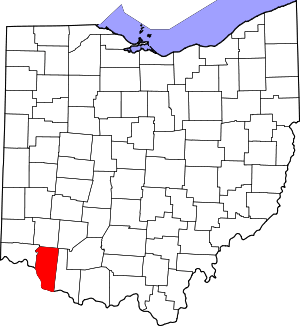 Map of Ohio highlighting Clermont County | |
| Villages | ||
| Townships | ||
| CDPs | ||
| Unincorporated settings |
| |
| Footnotes | ‡This populated place also has portions in an adjacent county or counties | |