Mowrystown, Ohio
Mowrystown is a village in Highland County, Ohio, United States. The population was 360 at the 2010 census.
Mowrystown, Ohio | |
|---|---|
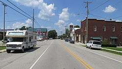 Looking west on Main Street | |
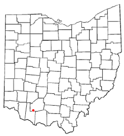 Location of Mowrystown, Ohio | |
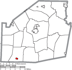 Location of Mowrystown in Highland County | |
| Coordinates: 39°2′20″N 83°45′9″W | |
| Country | United States |
| State | Ohio |
| County | Highland |
| Area | |
| • Total | 0.49 sq mi (1.3 km2) |
| • Land | 0.48 sq mi (1.2 km2) |
| • Water | 0.01 sq mi (0.03 km2) |
| Elevation | 997 ft (304 m) |
| Population | |
| • Total | 360 |
| • Estimate (2019[4]) | 352 |
| • Density | 730/sq mi (280/km2) |
| Time zone | UTC-5 (Eastern (EST)) |
| • Summer (DST) | UTC-4 (EDT) |
| ZIP code | 45155 |
| Area code(s) | 937, 326 |
| FIPS code | 39-53186[5] |
| GNIS feature ID | 1065081[2] |
History
Mowrystown was laid out in 1829, and named after Abe Mowry, an early settler.[6]
Geography
Mowrystown is located at 39°2′20″N 83°45′9″W (39.038827, -83.752457).[7] According to the United States Census Bureau, the village has a total area of 0.49 square miles (1.27 km2), of which 0.48 square miles (1.24 km2) is land and 0.01 square miles (0.03 km2) is water.[1]
Demographics
| Historical population | |||
|---|---|---|---|
| Census | Pop. | %± | |
| 1870 | 414 | — | |
| 1880 | 120 | −71.0% | |
| 1910 | 326 | — | |
| 1920 | 350 | 7.4% | |
| 1930 | 372 | 6.3% | |
| 1940 | 427 | 14.8% | |
| 1950 | 394 | −7.7% | |
| 1960 | 416 | 5.6% | |
| 1970 | 465 | 11.8% | |
| 1980 | 475 | 2.2% | |
| 1990 | 460 | −3.2% | |
| 2000 | 373 | −18.9% | |
| 2010 | 360 | −3.5% | |
| Est. 2019 | 352 | [4] | −2.2% |
| U.S. Decennial Census[8] | |||
2010 census
As of the census[3] of 2010, there were 360 people, 129 households, and 92 families living in the village. The population density was 750.0 inhabitants per square mile (289.6/km2). There were 152 housing units at an average density of 316.7 per square mile (122.3/km2). The racial makeup of the village was 99.7% White and 0.3% from two or more races.
There were 129 households of which 38.0% had children under the age of 18 living with them, 46.5% were married couples living together, 17.8% had a female householder with no husband present, 7.0% had a male householder with no wife present, and 28.7% were non-families. 23.3% of all households were made up of individuals and 12.4% had someone living alone who was 65 years of age or older. The average household size was 2.79 and the average family size was 3.27.
The median age in the village was 34.8 years. 28.1% of residents were under the age of 18; 7.5% were between the ages of 18 and 24; 27.6% were from 25 to 44; 21.9% were from 45 to 64; and 15% were 65 years of age or older. The gender makeup of the village was 50.6% male and 49.4% female.
2000 census
As of the census[5] of 2000, there were 373 people, 143 households, and 103 families living in the village. The population density was 772.8 people per square mile (300.0/km²). There were 162 housing units at an average density of 335.6 per square mile (130.3/km²). The racial makeup of the village was 98.66% White, 0.80% Pacific Islander, and 0.54% from two or more races.
There were 143 households out of which 37.8% had children under the age of 18 living with them, 55.2% were married couples living together, 11.9% had a female householder with no husband present, and 27.3% were non-families. 23.1% of all households were made up of individuals and 8.4% had someone living alone who was 65 years of age or older. The average household size was 2.61 and the average family size was 3.12.
In the village, the population was spread out with 28.2% under the age of 18, 10.5% from 18 to 24, 27.9% from 25 to 44, 22.5% from 45 to 64, and 11.0% who were 65 years of age or older. The median age was 34 years. For every 100 females there were 107.2 males. For every 100 females age 18 and over, there were 104.6 males.
The median income for a household in the village was $35,956, and the median income for a family was $37,917. Males had a median income of $31,250 versus $20,938 for females. The per capita income for the village was $13,884. About 11.6% of families and 10.1% of the population were below the poverty line, including 17.5% of those under age 18 and 18.8% of those age 65 or over.
Education
Mowrystown is the home of Whiteoak High School, home of the Whiteoak Wildcats.
References
- "US Gazetteer files 2010". United States Census Bureau. Archived from the original on 2012-01-24. Retrieved 2013-01-06.
- "US Board on Geographic Names". United States Geological Survey. 2007-10-25. Retrieved 2008-01-31.
- "U.S. Census website". United States Census Bureau. Retrieved 2013-01-06.
- "Population and Housing Unit Estimates". Retrieved May 21, 2020.
- "U.S. Census website". United States Census Bureau. Retrieved 2008-01-31.
- Overman, William Daniel (1958). Ohio Town Names. Akron, OH: Atlantic Press. p. 93.
- "US Gazetteer files: 2010, 2000, and 1990". United States Census Bureau. 2011-02-12. Retrieved 2011-04-23.
- "Census of Population and Housing". Census.gov. Retrieved June 4, 2015.
| Wikimedia Commons has media related to Mowrystown, Ohio. |
Municipalities and communities of Highland County, Ohio, United States | ||
|---|---|---|
| City |  Map of Ohio highlighting Highland County | |
| Villages | ||
| Townships | ||
| CDPs | ||
| Unincorporated communities | ||
| Footnotes | ‡This populated place also has portions in an adjacent county or counties | |