Mount Watatic
Mount Watatic is a 1,832-foot (558 m) monadnock located just south of the Massachusetts–New Hampshire border, in the United States, at the southern end of the Wapack Range of mountains. It lies within Ashburnham and Ashby, in Massachusetts, and New Ipswich, in New Hampshire; the 22 miles (35 km) Wapack Trail and the 92-mile (148 km) Midstate Trail both cross the mountain. The Yellow Arrow trail is 1.1 mile. Public parking for a half-hour (one way) hike to the summit is located on Massachusetts Route 119.
| Mount Watatic | |
|---|---|
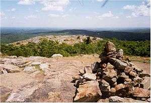 Summit of Mount Watatic. | |
| Highest point | |
| Elevation | 1,831 ft (558 m) |
| Prominence | 502 ft (153 m) |
| Coordinates | 42°41′48″N 71°53′33″W |
| Geography | |
| Location | Ashburnham and Ashby, Massachusetts, United States |
| Parent range | The Wapack Range |
| Geology | |
| Age of rock | 400 million years |
| Mountain type | monadnock; metamorphic rock |
The name is probably a corruption of the Native American term Wetu-tick, "wigwam brook," and probably applied first to the nearby large stream and thereafter to the mountain and the pond.[1]
The east and south side of the mountain drains into the Souhegan River watershed, to the Merrimack River thence the Atlantic Ocean; the west and north sides drain into the Millers River watershed, to the Connecticut River, thence into Long Island Sound.
Mount Watatic was the site of a ski area that operated from 1965 until 1984. An attempt to reopen the ski area in 1988 failed. The bald summit of the mountain featured a fire tower, open to the public, until its removal in 1996.
Conservation

In 2000, the summit of the mountain was sold to Industrial Communications and Electronics for the development of a 150-foot (46 m) cellular telephone tower and a road to the summit. In 2002, prior to development of the communications tower, the mountain was purchased for $2,500,000 by the Ashby Land Trust, the Town of Ashby, the Ashburnham Conservation Trust, the Town of Ashburnham, Mass Dept of Fish and Wildlife and Mass Dept of Conservation and Recreation. Unfortunately by this point a road had already been blasted into the ski area (back) side of the mountain, making several of the still maintained ski trails unusable. The purchase resulted in the permanent protection of approximately 281 acres (1.14 km2) of the mountain, including the summit, as conservation land. In July 2010, Mount Watatic was named one of the "1000 Great Places in Massachusetts" by the State Commission of Massachusetts.
References
- Kinnicutt, Lincoln N. (1905). Indian Names of Places in Worcester County Massachusetts with Interpretations of Some of Them (PDF). Worcester, Massachusetts. p. 53.
- Southern New Hampshire Trail Guide (1999). Boston: The Appalachian Mountain Club.
- Flanders, John (1991) Wapack Trail Guide. West Peterborough, New Hampshire: Friends of the Wapack.
- Mount Watatic State Reservation – The Massachusetts Department of Conservation and Recreation. Retrieved February 20, 2008.
- Davis, Jeremy (31 January 2005). "Mount Watatic Ski Area, Ashby, MA". New England Lost Ski Areas. NELSAP. Retrieved 17 September 2010.
- – State Commission of Massachusetts. Retrieved July, 2010.]
External links
| Wikimedia Commons has media related to Mount Watatic. |
- Friends of the Wapack
- Mount Watatic – New England Trail Review
- Mount Watatic Reservation maps (Massachusetts Department of Conservation and Recreation)