Mount Victory, Ohio
Mount Victory is a village in Hardin County, Ohio, United States. The population was 627 at the 2010 census. It is home to a quaint downtown main street along busy State Route 31 between Marysville and Kenton, and to a volunteer fire department.
Mount Victory, Ohio | |
|---|---|
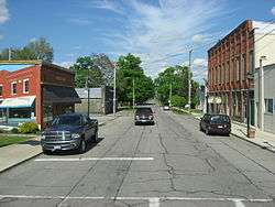 Downtown Mount Victory | |
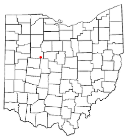 Location of Mount Victory, Ohio | |
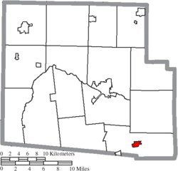 Location of Mount Victory in Hardin County | |
| Coordinates: 40°32′3″N 83°31′13″W | |
| Country | United States |
| State | Ohio |
| County | Hardin |
| Township | Hale |
| Area | |
| • Total | 0.77 sq mi (2.0 km2) |
| • Land | 0.77 sq mi (2.0 km2) |
| • Water | 0 sq mi (0 km2) |
| Elevation | 1,040 ft (320 m) |
| Population | |
| • Total | 627 |
| • Estimate (2019)[4] | 606 |
| • Density | 810/sq mi (310/km2) |
| Time zone | UTC-5 (Eastern (EST)) |
| • Summer (DST) | UTC-4 (EDT) |
| ZIP code | 43340 |
| Area code(s) | 937, 326 |
| FIPS code | 39-53144[5] |
| GNIS feature ID | 1043638[2] |
History
The town site of Mount Victory was surveyed in 1851, one year before the railroad was extended to that point.[6] The village received its name by reason of the proprietor shouting "Victory!" when he obtained the land.[7] A post office has been in operation at Mount Victory since 1854.[8]
Geography
Mount Victory is located at 40°32′3″N 83°31′13″W (40.534164, -83.520156).[9]
According to the United States Census Bureau, the village has a total area of 0.77 square miles (1.99 km2), all land.[1]
Demographics
| Historical population | |||
|---|---|---|---|
| Census | Pop. | %± | |
| 1880 | 574 | — | |
| 1890 | 689 | 20.0% | |
| 1900 | 734 | 6.5% | |
| 1910 | 740 | 0.8% | |
| 1920 | 723 | −2.3% | |
| 1930 | 597 | −17.4% | |
| 1940 | 645 | 8.0% | |
| 1950 | 609 | −5.6% | |
| 1960 | 598 | −1.8% | |
| 1970 | 633 | 5.9% | |
| 1980 | 667 | 5.4% | |
| 1990 | 551 | −17.4% | |
| 2000 | 600 | 8.9% | |
| 2010 | 627 | 4.5% | |
| Est. 2019 | 606 | [4] | −3.3% |
| U.S. Decennial Census[10] | |||
2010 census
As of the census[3] of 2010, there were 627 people, 249 households, and 172 families living in the village. The population density was 814.3 inhabitants per square mile (314.4/km2). There were 279 housing units at an average density of 362.3 per square mile (139.9/km2). The racial makeup of the village was 98.1% White, 0.6% African American, 0.5% Asian, 0.5% from other races, and 0.3% from two or more races. Hispanic or Latino of any race were 1.1% of the population.
There were 249 households of which 34.1% had children under the age of 18 living with them, 53.8% were married couples living together, 9.6% had a female householder with no husband present, 5.6% had a male householder with no wife present, and 30.9% were non-families. 24.9% of all households were made up of individuals and 8% had someone living alone who was 65 years of age or older. The average household size was 2.52 and the average family size was 2.95.
The median age in the village was 37.3 years. 25.4% of residents were under the age of 18; 8.3% were between the ages of 18 and 24; 25.1% were from 25 to 44; 24.9% were from 45 to 64; and 16.3% were 65 years of age or older. The gender makeup of the village was 49.3% male and 50.7% female.
2000 census
As of the census[5] of 2000, there were 600 people, 245 households, and 171 families living in the village. The population density was 791.3 people per square mile (304.8/km²). There were 263 housing units at an average density of 346.8 per square mile (133.6/km²). The racial makeup of the village was 98.83% White, 0.17% African American, and 1.00% from two or more races. Hispanic or Latino of any race were 0.83% of the population.
There were 245 households out of which 32.7% had children under the age of 18 living with them, 51.8% were married couples living together, 12.2% had a female householder with no husband present, and 30.2% were non-families. 25.7% of all households were made up of individuals and 11.0% had someone living alone who was 65 years of age or older. The average household size was 2.45 and the average family size was 2.86.
In the village, the population was spread out with 25.5% under the age of 18, 9.8% from 18 to 24, 28.8% from 25 to 44, 21.2% from 45 to 64, and 14.7% who were 65 years of age or older. The median age was 35 years. For every 100 females there were 92.9 males. For every 100 females age 18 and over, there were 93.5 males.
The median income for a household in the village was $40,694, and the median income for a family was $47,273. Males had a median income of $33,571 versus $22,344 for females. The per capita income for the village was $17,745. About 3.8% of families and 6.9% of the population were below the poverty line, including 6.1% of those under age 18 and 10.8% of those age 65 or over.
References
- "US Gazetteer files 2010". United States Census Bureau. Archived from the original on 2012-01-25. Retrieved 2013-01-06.
- "US Board on Geographic Names". United States Geological Survey. 2007-10-25. Retrieved 2008-01-31.
- "U.S. Census website". United States Census Bureau. Retrieved 2013-01-06.
- "Population and Housing Unit Estimates". Retrieved May 21, 2020.
- "U.S. Census website". United States Census Bureau. Retrieved 2008-01-31.
- Kohler, Minnie Ichler (1910). A Twentieth Century History of Hardin County, Ohio: A Narrative Account of Its Historical Progress, Its People and Principal Interests,. Lewis Publishing Company. p. 177.
- The History of Hardin County, Ohio. Warner Beers & Company. 1883. p. 654.
- "Hardin County". Jim Forte Postal History. Retrieved 14 December 2015.
- "US Gazetteer files: 2010, 2000, and 1990". United States Census Bureau. 2011-02-12. Retrieved 2011-04-23.
- "Census of Population and Housing". Census.gov. Retrieved June 4, 2015.
External links
Municipalities and communities of Hardin County, Ohio, United States | ||
|---|---|---|
| City |  Map of Ohio highlighting Hardin County | |
| Villages | ||
| Townships | ||
| CDP | ||
| Unincorporated communities | ||
| Footnotes | ‡This populated place also has portions in an adjacent county or counties | |
| Authority control |
|
|---|