Mount Sumagaya
Mount Sumagaya is a mountain on the northern section of Mindanao in the Philippines. It is under the jurisdictional territory of the municipality of Claveria. It stands at a height of about 2,248 metres (7,375 ft).[1]
| Mount Sumagaya | |
|---|---|
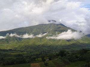 Mount Sumagaya, taken in Lanise, Claveria | |
| Highest point | |
| Elevation | 2,248 m (7,375 ft) [1] |
| Coordinates | 8°39′00″N 125°02′00″E |
| Geography | |
.svg.png) Mount Sumagaya Location within the Philippines | |
| Location | Mindanao |
| Country | Philippines |
| Region | Northern Mindanao |
| Province | Misamis Oriental |
| Municipality | Claveria |
| Parent range | Central Mindanao Cordillera |
| Geology | |
| Age of rock | unknown |
| Climbing | |
| Easiest route | Mat-i Trail |
It is part of the Central Mindanao Cordillera that stretches from Camiguin in the north to Sarangani in the south. The mountain rose to prominence during the crash of Cebu Pacific Flight 387 on its slopes in 1998, one of the deadliest aviation incidents in the Philippines.
See also
This article is issued from Wikipedia. The text is licensed under Creative Commons - Attribution - Sharealike. Additional terms may apply for the media files.