Mound Township, Warren County, Indiana
Mound Township is one of twelve townships in Warren County, Indiana, United States. According to the 2010 census, its population was 418 and it contained 183 housing units.[2]
Mound Township | |
|---|---|
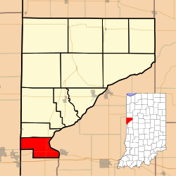 Location of Mound Township in Warren County | |
 Location of Indiana in the United States | |
| Coordinates: 40°08′52″N 87°28′12″W | |
| Country | United States |
| State | Indiana |
| County | Warren |
| Government | |
| • Type | Indiana township |
| Area | |
| • Total | 16.79 sq mi (43.5 km2) |
| • Land | 16.57 sq mi (42.9 km2) |
| • Water | 0.22 sq mi (0.6 km2) 1.31% |
| Elevation | 640 ft (195 m) |
| Population (2010) | |
| • Total | 418 |
| • Density | 25.2/sq mi (9.7/km2) |
| Time zone | UTC-5 (Eastern (EST)) |
| • Summer (DST) | UTC-4 (EDT) |
| Area code(s) | 765 |
| GNIS feature ID | 453656 |
History
Mound Township was one of the original four created when the county was organized in 1827.[3]
Geography
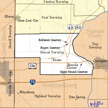
According to the 2010 census, the township has a total area of 16.79 square miles (43.5 km2), of which 16.57 square miles (42.9 km2) (or 98.69%) is land and 0.22 square miles (0.57 km2) (or 1.31%) is water.[2] The town of Foster is located just north of U.S. Route 136, about 1 mile (1.6 km) east of the township's southwestern border. Extinct communities in the township include Baltimore, which thrived on the banks of the Wabash River in the early 19th century, and Romine Corner. The streams of Kitchen Creek and Possum Run run through the township.
Cemeteries
The township contains these three cemeteries: Baltimore,[4] Rodgers[5] and Upper Mound.[6]
Transportation
U.S. Route 136 runs across the south part of the township, connecting Danville, Illinois to the west with Covington to the east.[7] Indiana State Road 63 runs from north to south in the eastern part of the township;[8] its child route of Indiana State Road 263 joins State Road 63 just north of the intersection with U.S. Route 136.[9] The 6-mile (10 km) Vermilion Valley Railroad serves the Flex-N-Gate factory near Covington and runs west from the plant through the town of Foster to meet a CSX line in Danville.[10][11]
Education
Mound Township is part of the Metropolitan School District of Warren County.[12]
Government
Mound Township has a trustee who administers rural fire protection and ambulance service, provides relief to the poor, manages cemetery care, and performs farm assessment, among other duties. The trustee is assisted in these duties by a three-member township board. The trustees and board members are elected to four-year terms.[13]
Mound Township is part of Indiana's 8th congressional district, Indiana House of Representatives District 42,[14] and Indiana State Senate District 38.[15]
References
- "US Board on Geographic Names". United States Geological Survey. October 25, 2007. Retrieved 2017-05-09.
- "Population, Housing Units, Area, and Density: 2010 - County -- County Subdivision and Place -- 2010 Census Summary File 1". United States Census. Archived from the original on 2020-02-12. Retrieved 2013-05-10.
- Warren County Historical Society 1966, p. 56.
- "Baltimore Cemetery". Geographic Names Information System. United States Geological Survey. Retrieved 2011-02-05.
- "Roger Cemetery". Geographic Names Information System. United States Geological Survey. Retrieved 2011-02-05.
- "Upper Mound Cemetery". Geographic Names Information System. United States Geological Survey. Retrieved 2011-02-05.
- "U.S. Route 136". Highway Explorer. Archived from the original on 2011-07-11. Retrieved 2010-09-21.
- "State Road 63". Highway Explorer. Archived from the original on 2012-03-09. Retrieved 2010-09-21.
- "State Road 263". Highway Explorer. Archived from the original on 2012-04-06. Retrieved 2010-09-21.
- "State of Indiana 2012 Rail System Map" (PDF). Indiana Department of Transportation. 2011. Retrieved 2011-06-19.
- "Employer Status Determination: Vermilion Valley Railroad Company, Inc". Railroad Retirement Board. 2003-06-30. Archived from the original on 2010-06-10. Retrieved 2010-08-28.
- "Corporation Snapshot, M S D Warren County #8115". Indiana Department of Education. Archived from the original on 2002-07-06. Retrieved 2011-01-27.
- "Government". United Township Association of Indiana. Retrieved 2011-01-06.
- "Indiana Senate" (PDF). State of Indiana. Retrieved 2013-12-02.
- "Indiana House Districts" (PDF). State of Indiana. Retrieved 2013-12-02.
- "Mound Township, Warren County, Indiana". Geographic Names Information System. United States Geological Survey. Retrieved 2009-09-24.
- United States Census Bureau TIGER/Line Shapefiles
Bibliography
- Goodspeed, Weston A. (1883). "Part II. History of Warren County". Counties of Warren, Benton, Jasper and Newton, Indiana. Chicago: F. A. Battey and Company. pp. 31–156. Retrieved 2010-09-19.
- Clifton, Thomas, ed. (1913). Past and Present of Fountain and Warren Counties Indiana. Indianapolis: B. F. Bowen and Company. pp. 201–335. Retrieved 2010-09-19.
- Warren County Historical Society (1966). A History of Warren County, Indiana. Williamsport, Indiana.
- Warren County Historical Society (2002). A History of Warren County, Indiana (175th Anniversary Edition). Williamsport, Indiana.
| Wikimedia Commons has media related to Mound Township, Warren County, Indiana. |
External links
Places adjacent to Mound Township, Warren County, Indiana | |
|---|---|
Municipalities and communities of Warren County, Indiana, United States | ||
|---|---|---|
| Towns | Map of Indiana highlighting Warren County | |
| Townships | ||
| Unincorporated communities | ||
| Ghost towns | ||
| Footnotes | ‡This populated place also has portions in an adjacent county or counties | |