Morrison, Tennessee
Morrison is a town in Warren County, Tennessee, United States. The population was 684 at the 2000 census and 694 at the 2010 census.
Morrison, Tennessee | |
|---|---|
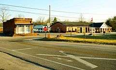 Intersection of TN-287 and TN-379, with city hall and library on the right | |
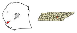 Location of Morrison in Warren County, Tennessee. | |
| Coordinates: 35°36′18″N 85°54′54″W | |
| Country | United States |
| State | Tennessee |
| County | Warren |
| Area | |
| • Total | 2.69 sq mi (6.96 km2) |
| • Land | 2.69 sq mi (6.96 km2) |
| • Water | 0.00 sq mi (0.00 km2) |
| Elevation | 1,073 ft (327 m) |
| Population (2010) | |
| • Total | 694 |
| • Estimate (2018)[2] | 712 |
| • Density | 264.88/sq mi (102.28/km2) |
| Time zone | UTC-6 (Central (CST)) |
| • Summer (DST) | UTC-5 (CDT) |
| ZIP code | 37357 |
| Area code(s) | 931 |
| FIPS code | 47-50220[3] |
| GNIS feature ID | 1294442[4] |
Geography
Morrison is located at 35°36′18″N 85°54′54″W (35.604869, -85.915004).[5]
According to the United States Census Bureau, the town has a total area of 2.7 square miles (7.0 km2), all of it land.
Demographics
| Historical population | |||
|---|---|---|---|
| Census | Pop. | %± | |
| 1910 | 149 | — | |
| 1920 | 271 | 81.9% | |
| 1930 | 265 | −2.2% | |
| 1940 | 278 | 4.9% | |
| 1950 | 301 | 8.3% | |
| 1960 | 294 | −2.3% | |
| 1970 | 379 | 28.9% | |
| 1980 | 587 | 54.9% | |
| 1990 | 570 | −2.9% | |
| 2000 | 684 | 20.0% | |
| 2010 | 694 | 1.5% | |
| Est. 2018 | 712 | [2] | 2.6% |
| Sources:[6][7] | |||
At the 2000 census there were 684 people, 254 households, and 185 families in the town. The population density was 251.9 people per square mile (97.1/km²). There were 276 housing units at an average density of 101.6 per square mile (39.2/km²). The racial makeup of the town was 88.45% White, 9.65% African American, 0.15% Native American, 1.02% from other races, and 0.73% from two or more races. Hispanic or Latino of any race were 2.49%.[3]
Of the 254 households 37.4% had children under the age of 18 living with them, 54.3% were married couples living together, 15.4% had a female householder with no husband present, and 26.8% were non-families. 22.8% of households were one person and 12.6% were one person aged 65 or older. The average household size was 2.62 and the average family size was 3.05.
The age distribution was 28.7% under the age of 18, 9.6% from 18 to 24, 27.9% from 25 to 44, 19.4% from 45 to 64, and 14.3% 65 or older. The median age was 35 years. For every 100 females, there were 85.9 males. For every 100 females age 18 and over, there were 83.5 males.
The median household income was $23,819 and the median family income was $31,250. Males had a median income of $28,125 versus $21,250 for females. The per capita income for the town was $13,105. About 20.6% of families and 23.9% of the population were below the poverty line, including 33.9% of those under age 18 and 9.2% of those age 65 or over.
Notable people
- Robert Brown, cartoonist.
- P. Allen Smith, gardening and lifestyle expert.
References
- "2018 U.S. Gazetteer Files". United States Census Bureau. Retrieved February 23, 2020.
- "Population and Housing Unit Estimates". United States Census Bureau. June 27, 2019. Retrieved June 4, 2019.
- "U.S. Census website". United States Census Bureau. Retrieved 2008-01-31.
- "US Board on Geographic Names". United States Geological Survey. 2007-10-25. Retrieved 2008-01-31.
- "US Gazetteer files: 2010, 2000, and 1990". United States Census Bureau. 2011-02-12. Retrieved 2011-04-23.
- "Census of Population and Housing: Decennial Censuses". United States Census Bureau. Retrieved 2012-03-04.
- "Incorporated Places and Minor Civil Divisions Datasets: Subcounty Resident Population Estimates: April 1, 2010 to July 1, 2012". Population Estimates. U.S. Census Bureau. Archived from the original on 11 June 2013. Retrieved 11 December 2013.
Municipalities and communities of Warren County, Tennessee, United States | ||
|---|---|---|
| City | ||
| Towns | ||
| Unincorporated communities | ||