Montsauche-les-Settons
Montsauche-les-Settons is a commune in the Nièvre department in the region of Bourgogne-Franche-Comté in central France. Administrative seat of the canton in northeastern Nièvre, Montsauche-les Settons is completely rural, the commune composed of a settlement, half of Lac des Settons (lake), and a few dispersed hamlets.
Montsauche-les-Settons | |
|---|---|
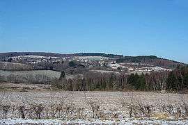 A general view of Montsauche-les-Settons | |
 Coat of arms | |
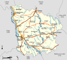
Location of Montsauche-les-Settons 
| |
 Montsauche-les-Settons  Montsauche-les-Settons | |
| Coordinates: 47°12′56″N 4°01′36″E | |
| Country | France |
| Region | Bourgogne-Franche-Comté |
| Department | Nièvre |
| Arrondissement | Château-Chinon (Ville) |
| Canton | Château-Chinon |
| Intercommunality | Les Grands Lacs du Morvan |
| Government | |
| • Mayor (2014–2020) | Marie Leclercq[1] |
| Area 1 | 44.30 km2 (17.10 sq mi) |
| Population (2017-01-01)[2] | 522 |
| • Density | 12/km2 (31/sq mi) |
| Time zone | UTC+01:00 (CET) |
| • Summer (DST) | UTC+02:00 (CEST) |
| INSEE/Postal code | 58180 /58230 |
| Elevation | 467–701 m (1,532–2,300 ft) |
| 1 French Land Register data, which excludes lakes, ponds, glaciers > 1 km2 (0.386 sq mi or 247 acres) and river estuaries. | |
Geography
The commune of Montsauche-les Settons is centrally located in Bourgogne-Franche-Comté in the Morvan mountainous massif, at the heart of the protected natural area of the Parc naturel régional du Morvan.
The settlement, located 3 km from the lake, contains all the businesses and essential services of the area. The lake area's economy is organized around tourism, while the principal economic activity of the surrounding hamlets is raising cattle and Christmas tree farming.
The associated historical place names of the area are:
|
|
Bordering Communes
See also
- Communes of the Nièvre department
- Parc naturel régional du Morvan
References
- https://www.montsauche-les-settons.org/page.php?page=mairie&entete=mairie
- "Populations légales 2017". INSEE. Retrieved 6 January 2020.
| Wikimedia Commons has media related to Montsauche-les-Settons. |
| Authority control |
|
|---|