Mont Agel
Mont Agel is a mountain on the border between France and Monaco. The summit of this mount, at 1,148 metres (3,766 ft) above sea level, is on the French side, but the highest point of Monaco, lying on a pathway named Chemin des Révoires, is on its slopes, at an altitude of 161 metres (528 feet).
| Mont Agel | |
|---|---|
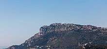
 View of Monaco with Mont Agel in the background | |
| Highest point | |
| Elevation | 1,148 m (3,766 ft) |
| Coordinates | 43°46′31″N 7°25′35″E |
| Geography | |
 Mont Agel France | |
| Location | Alpes-Maritimes, France / Monaco |
| Parent range | Maritime Alps |
History
The top of Mont Agel is occupied by Nice Air Base, itself built on the former Ouvrage Mont Agel of the Alpine Line fortifications.
On 18 June 2011, a light aircraft crashed onto Mont Agel, killing two British people. The plane was on a private flight, and was en route from Italy to Troyes at the time of the crash. Conditions were foggy.[1]
Mont Agel is the site of the Monte Carlo Golf Club, formerly home of the Monte Carlo Open. The club celebrated its 100th anniversary in 2011.
Roc Agel, purchased by Rainier III, Prince of Monaco as a summer family residence, is high on the slopes of Mont Agel.
See also
- Tête de Chien, another prominent mountain overlooking Monaco
- Geography of Monaco
- Geography of France
- List of countries by highest point
- List of highest paved roads in Europe
- List of mountain passes
References
External links
| Wikimedia Commons has media related to Mont Agel. |
- (in English) Map of Mont Agel, Monaco, MSN Encarta.
- (in French) Chemin des Révoires, Archeo Alpi Maritimi.
Monaco articles | |||
|---|---|---|---|
| History |  | ||
| Geography |
| ||
| Politics | |||
| Economy |
| ||
| Culture | |||
| |||