Momostenango
Momostenango is a town and municipality in the Totonicapán department of Guatemala. The municipality is situated in the North-West of Totonicapán, in the Western highlands of Guatemala.
Momostenango | |
|---|---|
Municipality | |
 Flag | |
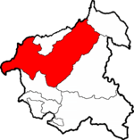 Momostenango within Totonicapán | |
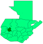 Totonicapán within Guatemala | |
| Coordinates: 15°02′40″N 91°24′30″W | |
| Country | |
| Department | |
| Government | |
| • Type | Municipal |
| Area | |
| • Municipality | 331 km2 (128 sq mi) |
| Elevation | 2,204 m (7,231 ft) |
| Population (2018 census)[2] | |
| • Municipality | 105,617 |
| • Density | 320/km2 (830/sq mi) |
| • Urban | 15,601 |
| • Ethnicities | K'iche', Ladino |
| • Religions | Catholicism, Evangelicalism, Maya |
| Climate | Cwb |
Population
Momostenango's population is predominantly of Maya K'iche' descent. 70% of the population live in rural areas and most are small farmers growing maize and beans for their own consumption, as well as wheat.
The municipality is subdivided in the town of Momostenango, 14 villages and 169 smaller communities called caseríos or parajes.[4]
Momostenango is the birthplace of the Maya K'iche' poet Humberto Ak'ab'al (1952-2019), who writes in K'iche' (Quiché) and in Spanish.
Geography
Momostenango borders to the North with the municipalities of Malacatancito (Huehuetenango, San Bartolo and Santa Lucía La Reforma, to its South with San Francisco El Alto and the municipality of Totonicapán, to the East with Santa María Chiquimula, and to the West with San Carlos Sija (Quezaltenango).
The municipality's territory of 305 km2 has a mountainous topography with elevations ranging from 1800 m in the North-East, to 3300 m (Cerro Tená) to the West. The mountains on its western border are a watershed for the Salinas and Samalá river basins. Most of the 49 waterflows are tributaries of the Chixoy River in the Salinas river basin.[1]
Like most of the central highlands, the climate is relatively cold, and is marked by a rainy season starting in mid-May, and a dry season starting in October. Yearly precipitation is around 1200 mm, except for the much dryer northern part of the municipality which receives 400–800 mm of rainfall.
Communities
The Municipality of Momostenango is divided into the following principal administrative units. [5]
Towns (Pueblos)
- Momostenango (municipal seat)
- Wards (Barrios): Patizité, Santa Ana, Santa Catarina, Santa Isabel
Villages (Aldeas)
- Chinimabé
- Los Cipreses
- Nicajá
- Patulup
- Pitzal
- Santa Ana
- San Antonio Pasajoc
- San Vicente Buenabaj
- Tierra Blanca
- Tierra Colorada
- Tunayac
- Tzanjon
- Xequemeyá
- Xolajap
Hamlets (Caseríos)
- Caserio Pasuc Momostenango
- Canquixajá
- Chojonacruz
- Chonimatux
- Choxacol
- Chuiabaj
- Jutacaj
- Nimtzituj
- Pancá
- Pologua
- Pueblo Viejo
- Rachoquel
- San José Sigüila
- Xeabaj
Places (Parajes)
- Chicorral
- Pamumus
References
- "Momostenango - Estrategia para la reducción de la pobreza municipal" (PDF). SEGEPLAN. 2002. Retrieved 2008. Check date values in:
|accessdate=(help) - Citypopulation.de Population of departments and municipalities in Guatemala
- Citypopulation.de Population of cities & towns in Guatemala
- Vinicio Alonso, Mario (2007). "Municipio de Momostenango, departamento de Totonicapán: Costos y rentabilidad de unidades pecuarias (producción de huevos y galinas" (PDF). Facultad de Ciencias Económicas, USAC. Retrieved 23 April 2009.
- "INFORMACION DEMOGRAFICA MOMOSTENANGO, TOTONICAPAN" (PDF). SEGEPLAN. 2010. Retrieved 12 October 2015.