Moelwyn Mawr
Moelwyn Mawr is a mountain in Snowdonia, North Wales and forms part of the Moelwynion. Its summit overlooks the Vale of Ffestiniog and has views in all directions.
| Moelwyn Mawr | |
|---|---|
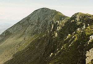 Moelwyn Mawr summit ridge | |
| Highest point | |
| Elevation | 770 m (2,530 ft) |
| Prominence | 385 m (1,263 ft) |
| Parent peak | Moel Siabod |
| Listing | Marilyn, Hewitt, Nuttall |
| Naming | |
| English translation | great white hill |
| Language of name | Welsh |
| Pronunciation | Welsh: [ˈmɔilwɨn ˈmaur] |
| Geography | |
| Location | Gwynedd, Wales |
| Parent range | Snowdonia |
| OS grid | SH658448 |
| Topo map | OS Landranger 124 |
| Listed summits of Moelwyn Mawr | ||||
| Name | Grid ref | Height | Status | |
|---|---|---|---|---|
| Moelwyn Bach | 710 m (2,329 ft) | Hewitt, Nuttall | ||
| Craigysgafn | 689 m (2,260 ft) | sub Hewitt, Nuttall | ||
| Moel-yr-hydd | 648 m (2,126 ft) | Hewitt, Nuttall | ||
| Moelwyn Mawr North Ridge Top | 640 m (2,100 ft) | Nuttall | ||
Site of Special Scientific Interest
In 1990, Moelwyn Mawr was designated a Site of Special Scientific Interest[1][2][3] of national scientific importance. The glaciated landscape of the mountain provides fine examples of two specific Pleistocene features. On the north-east flank of the mountain is a terrain of patterned ground, consisting of small-scale vegetated stripes. On the west side, a debris tongue formed by a rock glacier extends into Cwm Croesor.
Quarrying
Slate quarrying was a major industry for many years in the Moelwynion. Moelwyn Mawr's flanks have several major quarries on them. To the west is Croesor Quarry perched high above Cwm Croesor. To the north west is Rhosydd Quarry on the col between Cwm Croesor and Cwm Orthin. Within Cwm Orthin, Conglog and Wrysgan quarries are located on the north slope of the mountain. Within Cwm Ystradau to the east lies Moelwyn Slate Quarry.[4]
Walking
A common hike combines both Moelwyn Mawr and Moelwyn Bach via the Craigysgafn ridge.
A steep climb to the summit (which has a trig point) allows views of areas that cannot be seen without climbing.
Moelwyn Mawr has a high reservoir, Llyn Stwlan, which is part of the Ffestiniog Power Station pumped-storage hydroelectric power plant in Tanygrisiau.
The walk over the main peaks in the Moelwyns, those being Moelwyn Mawr and Moelwyn Bach involves a walk up a disused incline, before gaining the grassy slopes of Moelwyn Mawr and onto the rockier Moelwyn Bach, before walking back down the road from the Stwlan Dam. Both the Snowdonia and Harlech Ordnance Survey maps are needed to cover the walk. Transport to the beginning may be done by car to Tanygrisiau or Ffestiniog, or by train from Llandudno Junction.[5]
References
- "MOELWYN MAWR SITE OF SPECIAL SCIENTIFIC INTEREST, Citation (English)" (PDF). Countryside Council for Wales. 1990. Cite journal requires
|journal=(help) - "MOELWYN MAWR SITE OF SPECIAL SCIENTIFIC INTEREST, Citation (Cymryu)" (PDF). Countryside Council for Wales. 1990. Cite journal requires
|journal=(help) - "MOELWYN MAWR SITE OF SPECIAL SCIENTIFIC INTEREST, Map" (PDF). Countryside Council for Wales. 1990. Cite journal requires
|journal=(help) - Boyd, James I.C. (1975) [1959]. The Festiniog Railway 1800 - 1974; Vol. 2 - Locomotives and Rolling Stock; Quarries and Branches: Rebirth 1954-74. The British Narrow Gauge Railway. Blandford: The Oakwood Press. ISBN 978-0-85361-168-4. OCLC 874117875. B1B.
- Nuttall, John & Anne (1999). The Mountains of England & Wales - Volume 1: Wales (2nd edition ed.). Milnthorpe, Cumbria: Cicerone. ISBN 1-85284-304-7.