Mistik Creek
The Mistik Creek is a river in the Hudson Bay drainage basin in the Northern Region of Manitoba, Canada, approximately 20 kilometres (12 mi) northeast of Bakers Narrows.
| Mistik Creek | |
|---|---|
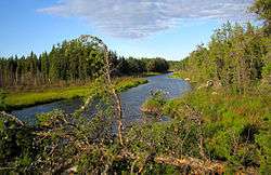 Mistik Creek looking upstream to the northeast between Nisto Lake and Nao Lake | |
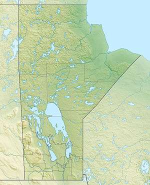 Location of Mistik Creek in Manitoba. | |
| Etymology | "Tree" in Cree |
| Location | |
| Country | Canada |
| Province | Manitoba |
| Region | Northern Region |
| Physical characteristics | |
| Source | Naosap Lake |
| ⁃ coordinates | 54°51′00″N 101°24′50″W |
| ⁃ elevation | 330.4 m (1,084 ft) |
| Mouth | Lake Athapapuskow |
⁃ coordinates | 54°37′32″N 101°34′06″W |
⁃ elevation | 291 m (955 ft) |
| Length | 44 km (27 mi) |
| Basin features | |
| River system | Nelson River drainage basin |
| Tributaries | |
| ⁃ left | Vamp Creek |
| ⁃ right | Holt Lake |
Description
The remote creek flows through Churchill River Upland portion of the Midwestern Canadian Shield forests and is surrounded by mixed forest with stands of black spruce, white spruce, jack pine, and trembling aspen. The shoreline is characterized by steeply sloping irregular rock ridges and poorly drained areas of muskeg.[1]
Mistik Creek area is largely pristine and home to moose, black bear, lynx, wolf, and beaver. It is part of the range of the Naosap woodland caribou herd.[2] Bird species include raven, common loon, spruce grouse, bald eagle and hawk owl. The creek is not easily accessible, but there is some trapping, hunting, and recreational fishing activity.[3]
Etymology
Mistik is Cree for "Tree".[4] The river is notable including fourteen lakes named in numeric order in Cree.[5] The fourteen lakes listed by their Cree names with the English translations in order from south to north are:
- Payuk Lake = One (outflow)
- Neso Lake = Two
- Nisto Lake = Three
- Nao Lake = Four
- Niyanun Lake = Five
- Nikotwasik Lake = Six
- Tapukok Lake = Seven
- Uyenanao Lake = Eight
- Kakat Lake = Nine
- Mitatut Lake = Ten
- Payukosap Lake = Eleven
- Nesosap Lake = Twelve
- Nistosap Lake = Thirteen
- Naosap Lake = Fourteen (source)[6]
Course
The river begins in Naosap Lake, and the upper lakes lie in very irregular basins with low banks surrounded by muskeg and flows slowly. Downstream, the lakes become smaller and the river portions form continuous rapids. At Neso Lake, the creek passes by the Neso Lake Provincial Park [5] and under Manitoba Highway 10 before emptying into Lake Athapapuskow via Payuk Lake's outflow Payuk Creek.
Canoe route
The "Mistik Creek Loop" is a well-known remote wilderness canoe trip which is 95 km (59 mi) in total length can be paddled in four to five days.[7] The route is characterized by many short, unmarked portages around small sets of rapids. It begins and ends at Bakers Narrows and relies on longer portages between Lake Athapapuskow, Alberts Lake and Naosap Lake[8]
Tributaries
- Holt Lake (right)
- Vamp Creek (left)
References
- Smith, R.E. (1998). Terrestrial Ecozones, Ecoregions, and Ecodistricts of Manitoba (PDF). Winnipeg, Manitoba: Agriculture and Agri-Food Canada. p. 88. ISBN 0-662-27446-6.
- Lander, Carrie-Anne (2006). Distribution and Movements of Woodland Caribou on Disturbed Landscapes in West-Central Manitoba: Implications for Forestry (PDF). Winnipeg, Manitoba, Canada: Natural Resources Institute, University of Manitoba. p. 57.
- "Ecoregions of Canada: Churchill River Uplands". Environment Canada. Retrieved 23 May 2014.
- Place-Names of Manitoba. Canadian Board on Geographical Names. 1933. p. 57.
- "Neso Lake Provincial Park Management Plan" (PDF). Govt of Manitoba. Retrieved 23 May 2014.
- Place-Names of Manitoba. Canadian Board on Geographical Names. 1933. p. 67.
- Schick, RoseAnna (2003-06-21). "Live the song of the paddles". Winnipeg Free Press. Retrieved 18 May 2014.
- Berard, Real (1968). Mistik Creek Canoe Route. Manitoba Dept. of Natural Resources. Archived from the original on 2014-05-18.
| Authority control |
|
|---|