Miloslavov
Miloslavov (Hungarian: Annamajor) is a village and municipality in western Slovakia in Senec District in the Bratislava Region.
Miloslavov | |
|---|---|
Municipality | |
 Church in Miloslavov | |
 Miloslavov Location of Miloslavov in the Bratislava Region 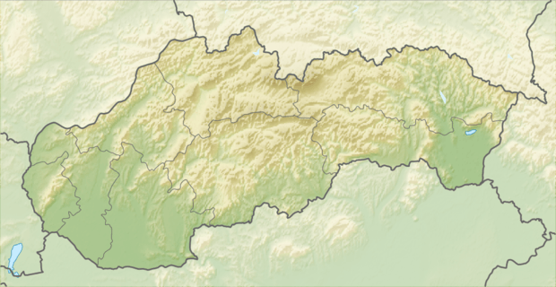 Miloslavov Miloslavov (Slovakia) | |
| Coordinates: 48°06′N 17°18′E | |
| Country | Slovakia |
| Region | Bratislava |
| District | Senec |
| Area | |
| • Total | 10.194 km2 (3.936 sq mi) |
| Elevation | 129 m (423 ft) |
| Population (2019) | |
| • Total | 3,016 |
| • Density | 300/km2 (770/sq mi) |
| Postal code | 900 42 (pošta Dunajská Lužná) |
| Area code(s) | 421-2 |
| Car plate | SC |
| Website | www.miloslavov.sk |
History
In historical records the village was first mentioned in 1332–1337.
Geography
The municipality lies at an altitude of 129 metres and covers an area of 10.194 km². It consists of two parts. Miloslava and Alžbetin Dvor. Both are now under heavy real estate investment which is happening now all around Bratislava.
Demographics
According to the 2011 census, the municipality had 1,780 inhabitants. 1,589 of inhabitants were Slovaks, 47 Hungarians, 12 Czechs and 132 others and unspecified.[1]
References
- "Archived copy" (PDF). Archived from the original (PDF) on 2012-11-14. Retrieved 2012-11-14.CS1 maint: archived copy as title (link)
External links/Sources
![]()
- Miloslavov - Webpage of Miloslavov
- https://web.archive.org/web/20070513023228/http://www.statistics.sk/mosmis/eng/run.html
This article is issued from Wikipedia. The text is licensed under Creative Commons - Attribution - Sharealike. Additional terms may apply for the media files.