Millerton, Kansas
Millerton is an unincorporated community in Sumner County, Kansas, United States.[2] It is located about 5 miles northeast of Conway Springs at the intersection of N Maple Rd and W 123rd Ave N, next to the railroad.
Millerton, Kansas | |
|---|---|
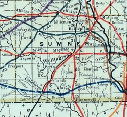 1915 Railroad Map of Sumner County | |
 KDOT map of Sumner County (legend) | |
 Millerton 1915 Railroad Map of Sumner County  Millerton Millerton (the United States) | |
| Coordinates: 37°26′12″N 97°33′23″W[1] | |
| Country | United States |
| State | Kansas |
| County | Sumner |
| Elevation | 1,345 ft (410 m) |
| Time zone | UTC-6 (CST) |
| • Summer (DST) | UTC-5 (CDT) |
| Area code | 620 |
| FIPS code | 20-46800 [1] |
| GNIS ID | 0484509 [1] |
History
Millerton had a post office from 1875 until 1912, but the post office there was called Rolling Green until 1884.[3]
Education
The community is served by Clearwater USD 264 public school district.
References
- Geographic Names Information System (GNIS) details for Millerton, Kansas; United States Geological Survey (USGS); October 13, 1978.
- "Sumner County". Blue Skyways. Kansas State Library. Archived from the original on 19 June 2013. Retrieved 27 June 2014.
- "Kansas Post Offices, 1828-1961, page 2". Kansas Historical Society. Retrieved 27 June 2014.
Further reading
External links
- Sumner County Map, KDOT
Municipalities and communities of Sumner County, Kansas, United States | ||
|---|---|---|
| Cities | 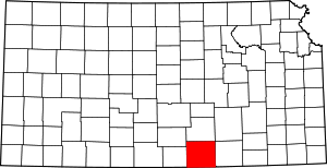 Map of Kansas highlighting Sumner County | |
| CDP | ||
| Unincorporated communities | ||
| Ghost towns |
| |
| Footnotes | ‡This populated place also has portions in an adjacent county or counties | |
This article is issued from Wikipedia. The text is licensed under Creative Commons - Attribution - Sharealike. Additional terms may apply for the media files.